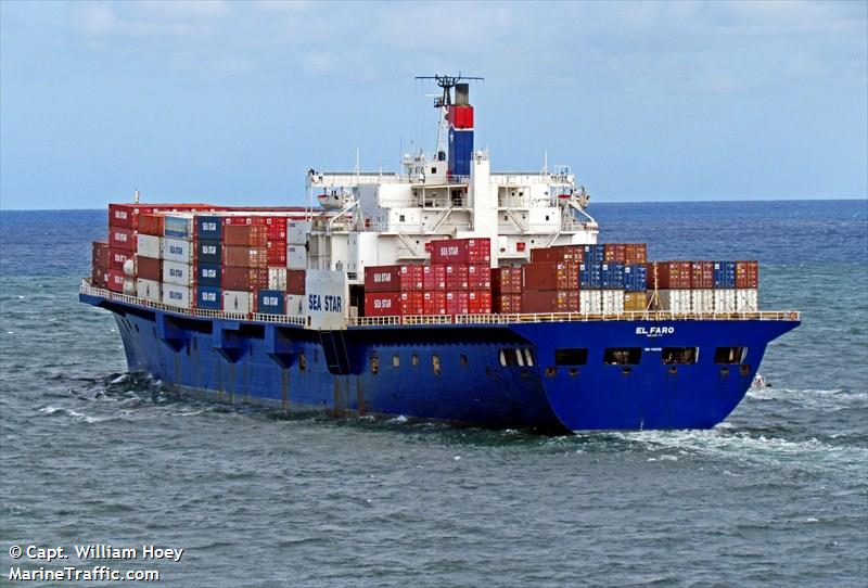
U.S.C.G. El Faro Hearings in Jacksonville

[QUOTE=z-drive;180218]and if he was, was it that kind of toxic enviroment where nobody would raise the concern (besides an email home)? or were they in the same situation?[/QUOTE]

The voyage might have been an aberration of the process. Andy Chase’s article about the Bounty points out that for the final voyage the normal procedure for decison making was not followed.There was a thread here about that article.

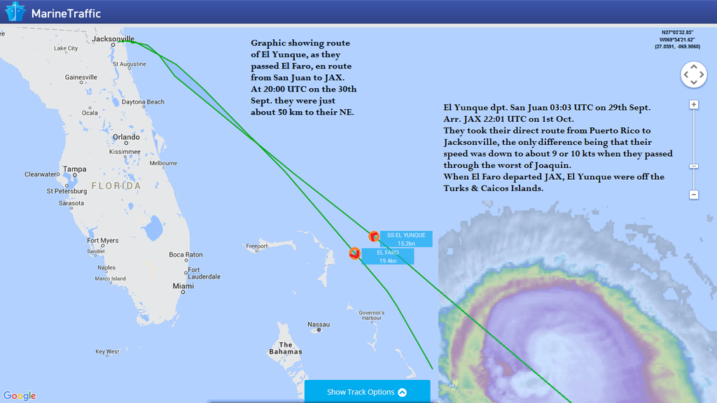
BTW, does anyonw know what time the Yunque and El Faro passed? The investigators talked to the El Yunque captain for hours reportedly. Their lines of questions during the hearing reflect what they learned about that converstaion between the two captains.

[QUOTE=Kennebec Captain;180299]

BTW, does anyonw know what time the Yunque and El Faro passed? [/QUOTE]

From the AIS I estimated it to have been at about 16:00 EDT on the 30th. About 25nm apart.

[QUOTE=Jamesbrown;180184]I think it would be interesting to perform a Substitution Test. In evaluating the behavior and actions of the Captain, it would be beneficial to take one or more similarly qualified individuals, placed in similar circumstances to make their own evaluations and take their own actions for comparison. This process can identify system errors as opposed to individual ones. In some ways, the discussions of the Forum can be seen as a limited substitution test, but the best comparable analysis would be a data driven one where the individuals face the same situation with the same information available.

I would offer that such a data set exists. The USCG/NTSB could obtain and analyze a re-play of all LRIT/AIS/AMVER data for vessel traffic over the period in the area of interest for the duration preceding. I’ve mentioned before that, based on the SAR commander’s comments there was very few ships (1?) in the area by a wide margin. Let’s see what the data says. Clearly, there would be limits in the conclusions, since it would not be immediately obvious what destination each vessel has (though this can be obtained from AIS data). Possibly run a couple of data sets that compare the Joaquin situation to maybe one or two other similar events (possible hurricane formation in the same area, differing forecast tracks…) and maybe a control data set of no storms to get an idea of normal traffic in the area of interest.[/QUOTE]

I don’t think there is going to be any question that the margins were insufficient. Tropical cyclones require larger margins than mid-latitude cyclones because of their unpredictable nature. At what point in the voyage the margins were not sufficient depends upon many factors including what techniques were used but it may have been as early as departure.

That said there are still reasons for a professional mariner to be interested in this incident.

[QUOTE=captjacksparrow;180181]
Exactly what weather information did they use, and why? Why was that route chosen and adhered to despite the forecasts and unfolding events? How often did El Faro receive updated wx information? If it didn’t go to the bridge when the master was asleep, why? Did shoreside managers normally monitor the voyages of any of their vessels and the weather that affects them? If so, to what degree? Would higher-risk voyages get more (or any) scrutiny from ashore? Does it depend on the specific vessel and/or master? If not, why? Did the shoreside managers monitor that particular voyage? If so, were they simpatico with the routing? If so, why? If they weren’t, did they attempt to do anything about it? Or were they oblivious to the unfolding disaster until the first phone call from the master? What specific resources were available to the master before departure and while en route? Were/are masters always simply left completely to their own devices and choices, regardless of any other considerations, with no particular monitoring of any kind? If so, is that a good way of operating a ship, or any other kind of vessel? Yes, the last two questions are rhetorical.

We may never get entirely honest or accurate answers to those questions, but I think if merchant mariners are interested in avoiding personal involvement in some version of a repeat performance it’s where the focus needs to be. We’re all fallible. If that inevitable fallibility isn’t recognized and factored carefully into our decision-making processes in all parts of voyage planning and execution then it should come as no surprise when it happens the next time. And of course there will always be a “next time.” It’s just a matter of who, when and where.[/QUOTE]

Exactly what weather information did they use, and why?

As to what did they get, AFAIK the ship would have been getting SAFETYNET forecast from NWS on the bridge. That would be every 6 hours or every three hours for hurricane warnings. If these were not being received, in my experience it would have been a no sail item. It’s standard practice to plot the text messages on a chart. Don’t know what the practice was on the El Faro.

As far as what they used, the question about the weather information was asked at the hearing. I didn’t watch the entire hearing but the only answer I heard was that it came in by email which would have been the separate paid system where the email updates the computer weather program. These were received by the captain and he forwarded them to the bridge. Of course that doesn’t mean that was the only method they were using.

Why was that route chosen and adhered to despite the forecasts and unfolding events?

That’s obviously the mystery, my guess is a combination of factors: Loss aversion, the hard loss of having to turn around compared to the less concrete gain of lower risk. Other possible factors are workload, overconfidence, normalization of deviance. Shipboard culture may have played a role, shoreside as well. I should add a disclaimer here that this is not meant as trying to excuse anyone’s actions. I’d be surprised if the company set the route, nobody ashore would want that responsibility.

Would higher-risk voyages get more (or any) scrutiny from ashore?

In my experience sometimes yes but the route near a tropical cyclone would be handled aboard ship but assistance is available on request.

Did the shoreside managers monitor that particular voyage? If so, were they simpatico with the routing? If so, why? If they weren’t, did they attempt to do anything about it? Or were they oblivious to the unfolding disaster until the first phone call from the master?

My experience is that the route is not monitored from ashore. One important point is that the master is the company representative. It depends on the wording of the SMS but traditionally on a ship where the crew signs articles the captain is a company representative, technically not part of the crew.

What specific resources were available to the master before departure and while en route? Were/are masters always simply left completely to their own devices and choices, regardless of any other considerations, with no particular monitoring of any kind?

Likely sufficient tools to analyze the weather but no monitoring from shoreside is my guess.

If so, is that a good way of operating a ship,

It’s the traditional way.In my view an obsolete way given modern sat comms.
[QUOTE=Kennebec Captain;180341]As far as what they used, the question about the weather information was asked at the hearing. I didn’t watch the entire hearing but the only answer I heard was that it came in by email which would have been the separate paid system where the email updates the computer weather program. These were received by the captain and he forwarded them to the bridge.[/QUOTE]

Isn’t it possible to sign up for all the traditional weather maps to be delivered by email as soon as their published?

[QUOTE=Kennebec Captain;180341]It’s the traditional way.In my view an obsolete way given modern sat comms.[/QUOTE]

I’ve read a very good argument recently that modern day comms have allowed the shore side managers to micro manage to the point where the skills and decision making ability of senior officers is decreased. I would say be careful what you wish for (more input from shore management) because you’ll probably hate it once you get it.

jacksparrow questions and KC replies are good. Mat’s weather / routing input excellent and lots of good side commentary as well.

It does remain a mystery why the Company was not having more input on a storm that was forecast and in fact did cross their mainline route. Let’s face it, Jax to San Juan is as straight line as it gets,and anything to disturb that should be of interest to the Company. I don’t buy off that they were passively uninterested. I have seen both sides of the equation as a mariner and a manager.

No - we do not tell the masters where to go exactly, but rather indicate the requirement to leave and arrive at the places indicated, more or less on the schedule shown, perils of the sea and ship excepted. Yes - that part goes to the master. But to think that if the ship was intending to pass within several hundred miles of a named storm and remain uninterested at the Company level… Aaaaaaaah no. Not a credible possibility.

As for shore input, now and in future, it seems " the office " should be making sure every captain has the information he needs, and feels free to communicate those needs early and often. AND that the responsible office teams respond accordingly.

A perfect place in an imperfect world - yes. It is so.

There was a systemic failure here, let’s not forget that.

Godspeed my young friends. We miss you.

It is still unclear what the exact chain of events were which probably started with the ship developing a list. Looking at the above picture I get the impression that the hull above the waterline looks rather like a Swiss cheese with all those openings. We must not forget that there also are large car doors in the side which if hit by a large body of water, that can act like a wall of concrete, can bring on severe damage that as a result can cause a leakage or worse. An example is what happened to the MSC Napoli while sailing in the British Channel. Due to huge waves a crack developed in one side and the engine room was flooded.

The list could also be caused by violent (parametric) rolling and pitching with heavy accelerations which could have damaged the container and /or car lashings. Shifting cargo will eventually lead to a list.

And there is the possibility that beam wind and waves could have worsened the list or if not already present started it. The requirements for this particular phenomenon is described in the IMO Resolution A.479(18) ‘Code for intact stability’ in paragraaf 4.6.3., the so called Weather Criterion.

A list can lead to a fatal incident if certain openings have not been closer properly. According to the Load Line Convention the lower edge of the ventilation opening that cannot be closed shall be placed at least 4500mm above the freeboard deck or 2300mm above the superstructure deck. The angle of heel at which the lower edges of any openings in the hull, superstructure or deckhouse which lead below deck and cannot be closed weathertight submerge is called the angle of downflooding for intact stability.

During the hearings there was a discussion about the ventilation openings of the car decks which require closing arrangements of adequate strength to ensure watertightness and structural integrity of the surrounding structure of the car decks and whether those watertight closings were indeed closed as they should have been.

[QUOTE=+A465B;180354]
It does remain a mystery why the Company was not having more input on a storm that was forecast and in fact did cross their mainline route. Let’s face it, Jax to San Juan is as straight line as it gets,and anything to disturb that should be of interest to the Company. I don’t buy off that they were passively uninterested. I have seen both sides of the equation as a mariner and a manager.

No - we do not tell the masters where to go exactly, but rather indicate the requirement to leave and arrive at the places indicated, more or less on the schedule shown, perils of the sea and ship excepted. Yes - that part goes to the master. But to think that if the ship was intending to pass within several hundred miles of a named storm and remain uninterested at the Company level… Aaaaaaaah no. Not a credible possibility.

As for shore input, now and in future, it seems " the office " should be making sure every captain has the information he needs, and feels free to communicate those needs early and often. AND that the responsible office teams respond accordingly.

A perfect place in an imperfect world - yes. It is so.

There was a systemic failure here, let’s not forget that.

Godspeed my young friends. We miss you.[/QUOTE]

With regards to the weather awareness, my experience is from a world-wide operation, if you are in the shit GC north of the Aleutians it’s lonely, with only some anonymous weather router for a friend. As far as coastwise if the strom is going to hit the destination port, then higher awarness then otherwise.

This situaiton here is much different, routine two port run.

If the company did not have a formal process for tracking the weather than they would have been vulnerable to being mislead by early forecast and media coverage. The coverage was heavy on the question of which major U.S. east coast city would get hit.

Looking for systemic failures here, not excuses.

[QUOTE=Capt. Phoenix;180346]Isn’t it possible to sign up for all the traditional weather maps to be delivered by email as soon as their published?[/QUOTE]

My guess is that likely there was more than enough weather info available. The fact that the captain did not have the weather automatically forwarded to the bridge caught my attention because this is the policy of some captains, they want to evaluate it before the mates see it.

EDIT: The SAFTEYNET and NAVTEX etc would still come direct to the wheelhouse.

I’ve read a very good argument recently that modern day comms have allowed the shore side managers to micro manage to the point where the skills and decision making ability of senior officers is decreased. I would say be careful what you wish for (more input from shore management) because you’ll probably hate it once you get it.

It’s an authority/responsibility thing. Problem is the downward flow of authority from top management to lowly deck hand is continuous but at the positon of master there is a discontinuity in the upward flow of responsibility. Times they are a changin’ but there is no motivation on the part of people in the chain above the master to change the status quo.

For my part I’m not wishing for anything, it’s just an observation.

[QUOTE=catherder;180225]I guess you’ve never seen this warning (from the NHC page about their graphic products and how to read them):

"NHC tropical cyclone forecast tracks can be in error…[/QUOTE]

Yes of course I have. But I was specifically referring to models “[B]purporting to show the forecast direction of a [U]developing Tropical Depression[/U][/B]”. I think the use of model tracks at the very early stage of a Trop Dep developing can be so unreliable as to be detrimental (note I said “can be”!). Hence the need for special caution when using them.

That said, I am definitely not suggesting that the weather forecasts later on didn’t give the Captain ample time and warning to take evasive action. All I am trying to recall here is the chronological development of the weather situation, to maybe help explain why there was some confusion as to the direction and strength of the storm initially. Then there is the difficulty of completely disregarding information already received, and formulating a new plan of action only using the new up-dated info. This requires 1) that you actually see the up-dated material, and 2) that you listen to what its telling you.

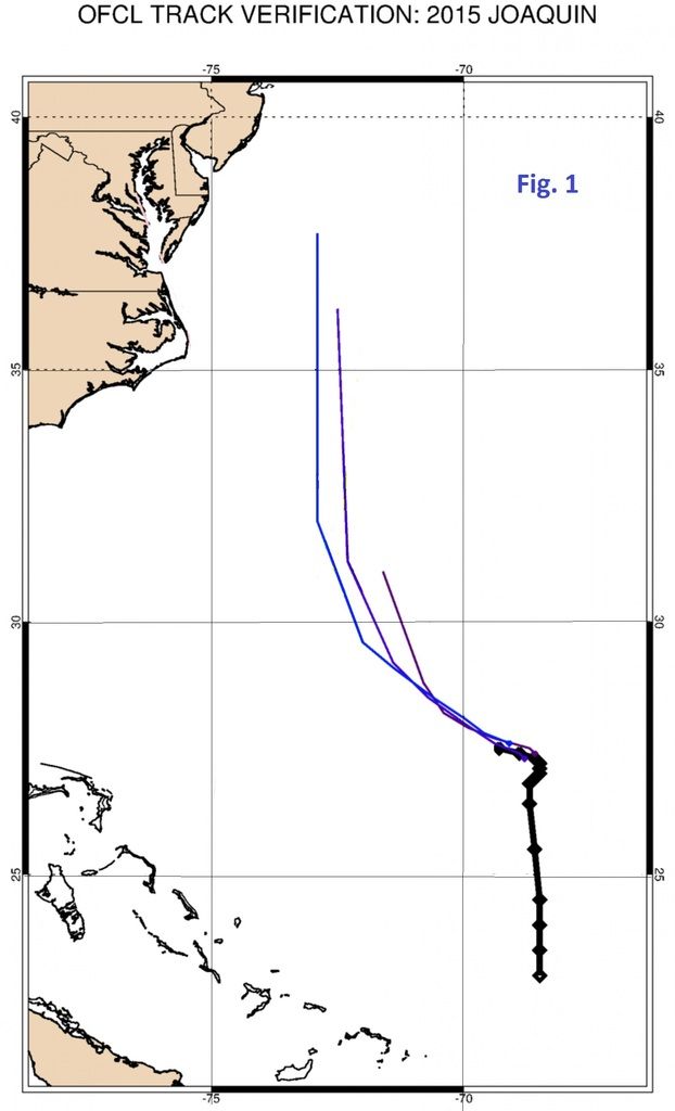
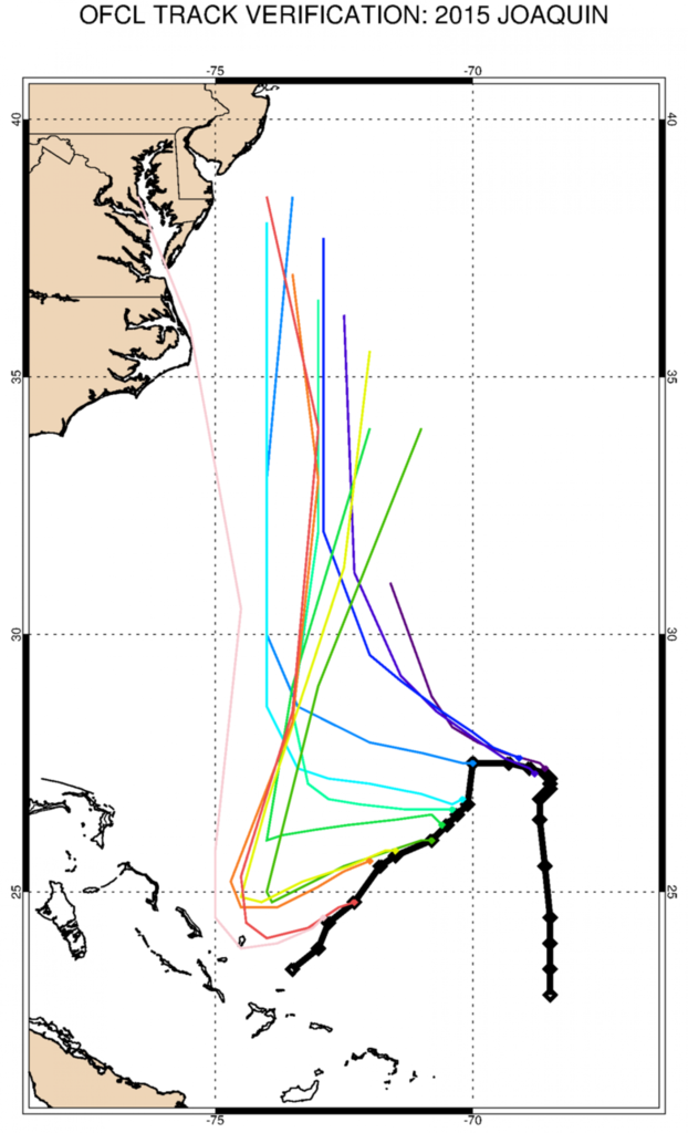
Look at the two graphics below:

These two both show the observed tracks of 11L (thick black dots) against the NHC forecasts (coloured lines).
It is hard to reconcile the massive disparity between the early track predictions and the final direction of travel. If you saw Fig. 1 only, you would confidently assume that 11L would in no way affect the Bahamas.
The second graphic shows how gradually you would have to re-think this assessment. But it is only a gradual process.
The graphic comes from an article written on Oct. 1st “Why the forecast cone of uncertainty is inadequate for Hurricane Joaquin” by Brian McNoldy (Washington Post).
"[I]So far, the official track forecasts for Hurricane Joaquin have not performed well. Joaquin has drifted to the southwest almost since it formed, while many models and and the National Hurricane Center, forecasted a turn to the west and north. All along Joaquin’s path thus far, the official forecast track has been adjusted over and over as the storm drifted farther and farther away from where it was forecast to be.
Unfortunately, the track hasn’t been the only forecast struggle with the storm. Hurricane Joaquin’s rapid intensification has been incredible. While Joaquin’s origins as an upper-level low pressure system can be traced back about two weeks, it was only three days ago that it was declared a tropical depression. Just Wednesday morning it was still a tropical storm, and now it is a strengthening Category 3 hurricane.
These “Bahama Busters,” or storms that explosively intensify over or near the Bahamas, are notorious because the deep warm water there combined with the proximity to land make them extremely dangerous[/I]."

In contrast here is the forecast tracks for T/S Erika.

Routing for Joaquin in time to avoid trouble was a very solvable problem. However the nature of the problem of Joaquin is very different than the problem of Erika.

[QUOTE=Mat;180366] Then there is the difficulty of completely disregarding information already received, and formulating a new plan of action only using the new up-dated info. This requires 1) that you actually see the up-dated material, and 2) that you listen to what its telling you.
[/QUOTE]

This is an issue. With a full inbox problems are going to be categorized, I’ve seen a grid, important, not important, urgent, not urgent.

It’s plausible (I’m not saying it’s right I’m saying it could happen.) that looking at the forecast tracks Joaquin might not be seen as an urgent issue and it can be put off while other matters, that are both urgent and important can be dealt with. If you sail captain you know sometimes in port it can be a long list.

A second factor is how people process information that is probabilistic by nature. Unless someone makes a conscious effort not to let it happen information given in terms of percentage is reduced to “will happen”, “won’t happen” and “maybe”. It’s possible that when evaluating Joaquin before sailing it went in the “won’t happen” category when it belonged in the “maybe” category.

Once the voyage was in progress there is the problem that the cost of turning back gets higher and higher the further along the track while the gain of turning back, that of lower risk, is less concrete. The cost of turning back is “will happen” and the risk is, worse case scenario (at the turning point), maybe.

The way to avoid this is just as a rule plot everything regardless.

[QUOTE=Mat;180366]These two both show the observed tracks of 11L (thick black dots) against the NHC forecasts (coloured lines). It is hard to reconcile the massive disparity between the early track predictions and the final direction of travel. [/QUOTE]

none of the early predictions matter at all…all that DOES matter are the final 12 hours when the forecasts had Joachim headed right for the vicinity due north of Crooked Island and EL FARO on a course to intersect the eyewall. Nobody can use what was in the early data to excuse not seeing the dangers presented by late data. By its very nature, weather is dynamic and a seasoned mariner is always looking for changes. With today’s satellite broadcasts of up to the hour weather predictions there is no excuse whatsoever to miss anything.

this is the forecast for JOACHIM at 2300lt 0n 9/30…there is no doubt left that EL FARO is going to intersect the storm’s center.

[QUOTE=c.captain;180375]none of the early predictions matter at all…[/QUOTE]

I agree that none of the early predictions should matter at all, but because of what subsequently occurred, they are of interest in a purely academic way, to help perhaps understand the context of what happened. Nobody is using them to excuse or justify what happened. Merely to help explain what might have contributed to the fact that numerous interested parties apparently took their eyes off the ball as Joaquin closed on the Bahamas.
I would argue that if it was as clear cut as we are all tempted to suggest then there should have been various other responses happening that apparently didn’t:
1)the captain of El Yunque should have harangued his fellow master on El Faro and told him to stay the hell out of dodge because a storm was just about to explode and cut him off;
2)the chaps in the office should have been demanding to know why the ship was still steaming full speed towards the storm;
3)everyone with $10 invested in the ship should have been doing the same, each in their own way;
4)and the coastguard chappy should have been tearing his hair out when he heard that a US cargo ship was disabled a few short miles away from an incoming Bahama Buster

Next to why the storm wasn’t given a wider berth, this is the most inexplicable.

And not advising to anchor 10k+ feet of water.

[QUOTE=Fraqrat;180381]And not advising to anchor 10k+ feet of water.[/QUOTE]

I know, right?!?!

[QUOTE=Mat;180366]Yes of course I have. But I was specifically referring to models “[B]purporting to show the forecast direction of a [U]developing Tropical Depression[/U][/B]”. I think the use of model tracks at the very early stage of a Trop Dep developing can be so unreliable as to be detrimental (note I said “can be”!). Hence the need for special caution when using them.

That said, I am definitely not suggesting that the weather forecasts later on didn’t give the Captain ample time and warning to take evasive action. All I am trying to recall here is the chronological development of the weather situation, to maybe help explain why there was some confusion as to the direction and strength of the storm initially. Then there is the difficulty of completely disregarding information already received, and formulating a new plan of action only using the new up-dated info. This requires 1) that you actually see the up-dated material, and 2) that you listen to what its telling you.

Look at the two graphics below:

These two both show the observed tracks of 11L (thick black dots) against the NHC forecasts (coloured lines).
It is hard to reconcile the massive disparity between the early track predictions and the final direction of travel. If you saw Fig. 1 only, you would confidently assume that 11L would in no way affect the Bahamas.
The second graphic shows how gradually you would have to re-think this assessment. But it is only a gradual process.
The graphic comes from an article written on Oct. 1st “Why the forecast cone of uncertainty is inadequate for Hurricane Joaquin” by Brian McNoldy (Washington Post).
"[I]So far, the official track forecasts for Hurricane Joaquin have not performed well. Joaquin has drifted to the southwest almost since it formed, while many models and and the National Hurricane Center, forecasted a turn to the west and north. All along Joaquin’s path thus far, the official forecast track has been adjusted over and over as the storm drifted farther and farther away from where it was forecast to be.
Unfortunately, the track hasn’t been the only forecast struggle with the storm. Hurricane Joaquin’s rapid intensification has been incredible. While Joaquin’s origins as an upper-level low pressure system can be traced back about two weeks, it was only three days ago that it was declared a tropical depression. Just Wednesday morning it was still a tropical storm, and now it is a strengthening Category 3 hurricane.
These “Bahama Busters,” or storms that explosively intensify over or near the Bahamas, are notorious because the deep warm water there combined with the proximity to land make them extremely dangerous[/I]."[/QUOTE]

I understand what you’re saying. He (the Capt) went to bed fairly confident that Joaquin was going to remain well north of his planned track and overnight, the forecast changed radically. But that’s not the first time such a thing has happened before. In the future, would the prudent thing be to have someone- the mate on watch perhaps- look over the updated data and inform the Captain if things change for the worse?

I’ve been on trips where we dodged and routed around a hurricane, and even though I’m not privy to what goes on upstairs, I got the impression that all the bridge watches were keeping an eye peeled on the weather.

Edit- I know you guys discussed that further up the thread. It’s just me kinda thinking out loud.

[QUOTE=catherder;180387]I understand what you’re saying. He (the Capt) went to bed fairly confident that Joaquin was going to remain well north of his planned track and overnight, the forecast changed radically. But that’s not the first time such a thing has happened before. In the future, would the prudent thing be to have someone- the mate on watch perhaps- look over the updated data and inform the Captain if things change for the worse? [/QUOTE]

NO! The storm’s prognosis was very well established before Davidson would have retired. All the NWS products are available in an archive and you can see all the way back to 2pm on the 30th that Joachim was headed south and that the EL FARO would have been on a collision course with the storm as long as it held to it’s track without slowing or stopping. This is what is so inexplicable!

[QUOTE=c.captain;180388]NO! The storm’s prognosis was very well established before Davidson would have retired. All the NWS products are available in an archive and you can see all the way back to 2pm on the 30th that Joachim was headed south and that the EL FARO would have been on a collision course with the storm as long as it held to it’s track without slowing or stopping. This is what is so inexplicable![/QUOTE]

I’m looking at the animated loop. The storm track took a frightening dip south between the 8 am and the 11 am advisories. I’m not trying to rehash the whole thread, just trying to understand better what happened upstairs. Yeah…inexplicable doesn’t even begin to describe it.

http://www.nhc.noaa.gov/archive/2015/graphics/al11/loop_3W.shtml

This graphic is pretty neat. You an animate it in either direction or flip through at your own pace.

[QUOTE=catherder;180387]I understand what you’re saying. He (the Capt) went to bed fairly confident that Joaquin was going to remain well north of his planned track and overnight, the forecast changed radically. But that’s not the first time such a thing has happened before. In the future, would the prudent thing be to have someone- the mate on watch perhaps- look over the updated data and inform the Captain if things change for the worse?

I’ve been on trips where we dodged and routed around a hurricane, and even though I’m not privy to what goes on upstairs, I got the impression that all the bridge watches were keeping an eye peeled on the weather.

Edit- I know you guys discussed that further up the thread. It’s just me kinda thinking out loud.[/QUOTE]

There is not enough information at this point to narrate a credible scenario. Instead this dissucssion is more along the lines of possible factors.

The fact that the forecast changed from not a threat to a very real threat is just a possible factor. Same with night/day timing. It’s more likely the ship would have difficulty responding to changes in the situation at night than during the day, another possible factor.

WIth regards to the position of the center of the system, a lot of mariners focus on the center but it’s important to look at the wind and wave fields as well, possibly more important.

That’s why hurricane avoidance advice is often given with respect to the 34 kt wind field and not given as in terms of distance from the center. Distance from the center does not take into account size or strength of the system.

In this case Davidson may have been looking at wind speed and wave heights to justify standing on.