U.S.C.G. El Faro Hearings in Jacksonville

[QUOTE=Dutchie;180069]Interesting blog about the El Faro incident by David Burch. I have his book ‘Emergency Navigation’ on the bookshelf. One of the comments made by a retired Chief Engineer with 35 years experience struck me.Is it true that one boiler was shut down for repairs?[/QUOTE]

No, that was all speculation because the boilers were coming due for an overhaul and that they had Polish fitters on board. The Poles were there to get her ready for the Alaska trade which was mostly deicing piping for the ramps.

Also, while he may be a smart guy, David Burch is a yacht guy. He holds a 100 ton license.

[QUOTE=Dutchie;180069]Is it true that one boiler was shut down for repairs?[/QUOTE]

the way I understand it is on a previous voyage, permission was requested and received to shut down a boiler enroute to conduct inspections but no such action was planned for the fatal voyage HOWEVER, we can assume that the plant was not 100% by any means, One boiler was flagged to receive repairs in November and by inference, we can gather that there would be other pending work to be done with the plant.

THROUGHOUT THIS ENTIRE TERRIBLE TRAGEDY, THERE SEEMS TO BE A WALL OF SILENCE CONCERNING THE ACTUAL CONDITION OF THE PLANT NOR WHAT HAPPENED TO CAUSE THE SHIP TO GO DIW WHEN IT DID, YET THE FACT REMAINS THAT DAVIDSON STILL TOOK THE EL FARO INTO PERIL WHETHER THE PLANT WAS FULLY FUNCTIONAL OR IF IT HAD DEFICIENCIES! Maybe there is a slightly lesser reason to condemn him if the plant was good in all respects than if he challenged a strong hurricane with a weak leg but he can NEVER be excused. Any master MUST always know the condition of every system in his ship because without that knowledge, the basis for making critical decisions can never be considered as sound.

[QUOTE=Dutchie;180069]Interesting blog about the El Faro incident by David Burch. I have his book ‘Emergency Navigation’ on the bookshelf. One of the comments made by a retired Chief Engineer with 35 years experience struck me.Is it true that one boiler was shut down for repairs?

Slamming and severe accelerations caused by a heavily rolling and pitching ship could lead to all kinds of damage, also in the engine room especially when this is not in a shipshape condition.[/QUOTE]

Burch is right. The NWS forecast on the 28th has Joaquin moving north but when the ship departed the forecast had changed and as of 29/1100 local time the forecast was for the system to move towards the Bahamas. The ship left 29/2010 according to TOTE.

The ship may have been relying on the computer weather which is the go-to tool, especially when busy and short on time. Like the ECDIS the weather program can give a false sense of accuracy and precision. The 1500 UTC forecast likely showed that the track ducking south of San Salvador was outside the 34 kt wind field… The computer does not (in my experience) show the uncertainty or the possible forecast error.

There is a recommendation that this plotting be done by hand on a paper chart. After the forecast errors are applied that entire route is cut off as of sailing time.

[QUOTE=c.captain;180072]the way I understand it is on a previous voyage, permission was requested and received to shut down a boiler enroute to conduct inspections but no such action was planned for the fatal voyage HOWEVER, we can assume that the plant was not 100% by any means, One boiler was flagged to receive repairs in November and by inference, we can gather that there would be other pending work to be done with the plant.

THROUGHOUT THIS ENTIRE TERRIBLE TRAGEDY, THERE SEEMS TO BE A WALL OF SILENCE CONCERNING THE ACTUAL CONDITION OF THE PLANT NOR WHAT HAPPENED TO CAUSE THE SHIP TO GO DIW WHEN IT DID, YET THE FACT REMAINS THAT DAVIDSON STILL TOOK THE EL FARO INTO PERIL WHETHER THE PLANT WAS FULLY FUNCTIONAL OR IF IT HAD DEFICIENCIES! Maybe there is a slightly lesser reason to condemn him if the plant was good in all respects than if he challenged a strong hurricane with a weak leg but he can NEVER be excused. [COLOR=“#00FF00”]Any master MUST always know the condition of every system in his ship because without that knowledge, the basis for making critical decisions can never be considered as sound.[/COLOR][/QUOTE]

Reading this part of the hearing on the boilers one would say that your statement in red is rather spot on.

The board asked Mr. Laasko about the condition of both her boilers, and whether the maintenance scheduled for them was sufficient in its scope and timeliness.

Mr. Laasko told the board that he holds no certifications, but has 22 years of experience in the field. Walashek Industrial, his employer, is the “largest provider of services to marine propulsion boilers in the United States,” with service facilities in Seattle, Portland, Norfolk, Mobile, San Diego and Charleston.

He was asked to read selections of his El Faro survey report into the record, reproduced from his testimony below.

The forward and rear firestops are starting to fall apart, toward the top of each stop, and holes are starting to show. The left stop, when facing the screen tubes, has pushed the first screen tube away from the wall, so that it touches the next screen tube.

The front wall on starboard boiler is in very bad shape. The brick wall in spots has pushed itself against the tubes and in turn pushes the tubes out causing them to bow in towards the firebox. Other parts of the wall have begun to deteriorate and there is now a three to four inch gap between the wall and the tubes. As the tubes are pushed out, tubes around the burner throats have begun to show signs of flame impediment.

After discussions with the chief, first assistant, and second assistant, it can be assumed that the port boiler firebox is in the same if not worse condition than the starboard boiler. All three have said that the front wall brick and tubes are in very bad shape.

It is highly recommended that the front wall tubes as well as brickwork, including burner throats, be renewed on both boilers. The brick is moving due to soot buildup behind them and as a result can cause casing fires as well as damage to tubes to the point of failure. The deterioration of the brick can also cause inner casings to fail from lack of heat resistant brick and insulation in front of it.

In follow-up questioning, TOTE’s representative at the hearing asked Laasko, "the negative things that were cited by the Coast Guard . . . those are efficiency items, aren’t they?

Laasko responded affirmatively, that these were efficiency items, not safety items. Separately he noted that while there was "definitely some work that needed to be done,” he “didn’t feel unsafe around those boilers,” and if there had been a safety concern he would have notified the vessel’s engineers.

The survey was completed as part of a pre-shipyard assessment for a yard period coming up in November. Walashek Industrial’s repair estimate, prepared for TOTE after the survey, included only “burner throats on both boilers, remove slag from firebox decks, clear gas passes,” leaving out parts of the recommended firebox work from Laasko’s survey, plus his additional recommendation for retubing on the starboard economizer.

The board produced an email between chief engineer James Robinson and TOTE executive Tim Neeson from July 2015 regarding the deteriorating condition of her boilers, and asked Laasko whether he thought it prudent to leave the maintenance unaddressed between July and November (or longer, if the full extent of work was not scheduled for November’s shipyard). He told the board that this was not his call, and that he “would recommend that it be fixed right away . . . but it’s really up to the ship’s owner at that point.”

“It could lapse a couple of months, it wouldn’t be a big deal,” he added.

He was not involved in any discussions with shoreside TOTE officials, and allowed that another firm besides Walashek Industrial could have been chosen to quote the remaining parts of his recommended scope of work. The repairs were to be done in Portland or Seattle, and Walashek has competitors in both markets.
Referring to the green text it was said that Davidson was hands off. If this is true it could mean that he was not well informed of the propulsion’s condition and was not hampered by that in his decision to push on.
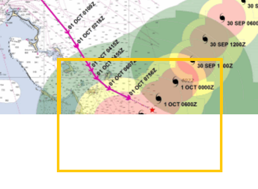
One thing I must admit I feel has been glossed over by this forum is the matter of the “scuttle” being open. KC has brought it up a several times, notably in post #68, along with an excellent elevation sketch of the ship. But I have yet to come across a long discussion on the subject of the scuttle.

Most people are in agreement: the ultimate cause of the disaster was the decision (for whatever reason) to route the ship in the path of a hurricane. No doubt. I have little doubt that the cargo shifted, as many have speculated, which was the proximate cause of the sinking. But as is the often the case with ship disasters there was a string of causation, any event of which, had it not happened, would have allowed the ship to survive. Therefore my interest in the scuttle.

I have little faith in coincidences. An argument that the ship listed to 15 degrees at roughly at the same time the main plant was lost for unrelated reasons strains credulity. It is on the order of a car driving down the highway blowing out a tire and losing the fuel pump within the space of five minutes. Possible, yes. Probable, no.

Therefore the size and location of the scuttle, the source of the flooding that disabled the main plant, are an essential part of this story. Captain Davidson says in his first call that a scuttle blew open on #2 deck and allowed water to flood into #3 hold, but what “scuttle” are we referring to? What else did it communicate with, open air or another compartment? How large was it? A horizontal hatch, a sideport or a WTD? Someone reading this probably has an idea. Perhaps even has a photo. 

When I hear “scuttle” I think of a small opening.  A WTD. A manhole. No larger. In other words, small. Is this what we are talking about?

If the scuttle was small it would have taken awhile for enough water to flood to cause a ship that size to take on a 15 degree list. Surely someone would have noticed the ship begin to list long before it got to 15 degrees, if the “scuttle” was small. The captain states this happened in a “storm”. He might have used the term colloquially to indicate just general bad weather. But if the weather was violent enough to open the scuttle I presume it would have heeled the ship over to a minor degree which would have been the beginnings of the free-surface list. I’ve worked on a containership (SS Diamond State, T-ACS-7, 1990). On that ship people started getting excited at a 5 degree roll, let alone a 5 degree list, and she was only 668’ LOA. I can’t imagine a small list getting progressively larger with no one noticing it. So why did it take so long to notice and report?

On the other hand, if the scuttle was large then flooding would have happened proportionally faster. [I]So how large was the scuttle, where was it located, and what compartment/weather deck did it communicate with?[/I] How does such a scuttle come to “pop open in a storm” (I paraphrase closely what Captain Davidson said himself)? Do other ships, sister ships, have the same scuttle in the same spot? Because if the mechanism for securing them is liable to have the same problem, especially if (and I say IF) aging is an issue, then there is another disaster waiting to happen.

The Preliminary Report of the National Transportation Safety Board, issued on October 15, 2015, tells the story as follows:
On Thursday, October 1, 2015, about 07:15 a.m. eastern daylight time, the US Coast Guard received distress alerts from the 737-foot-long roll-on/roll-off cargo ship El Faro. The US flagged ship, owned by Sea Star Line, LLC, and operated by TOTE Services (TOTE), was 36 nautical miles northeast of Acklins and Crooked Islands, Bahamas, and close to the eye of Hurricane Joaquin. The ship was en route from Jacksonville, Florida, to San Juan, Puerto Rico, with a cargo of containers and vehicles. Just minutes before the distress alerts, the El Faro master had called TOTE’s designated person ashore and reported that the ship was experiencing some flooding. He said the crew had controlled the ingress of water but the ship was listing 15 degrees and had lost propulsion. The Coast Guard and TOTE were unable to reestablish communication with the ship. Twenty-eight US crewmembers and five Polish workers were on board.
The Coast Guard deployed helicopters and search vessels to the ship’s last known position, but the search was hampered by hurricane force conditions on scene. On Sunday, October 4, a damaged lifeboat, two damaged liferafts, and a deceased crewmember wearing an immersion suit were found. On Monday, October 5, a debris field and oil slick were found, and the Coast Guard determined that the El Faro was lost and declared the event a major marine casualty. The Coast Guard suspended the unsuccessful search for survivors at sundown on Wednesday, October 7.
This voyage and the progression of the hurricane were also described by the NTSB. In a press release distributed on October 20, 2015, the NTSB described the sequence of events as follows:

Before El Faro departed Jacksonville, Tropical Storm Joaquin was predicted to become a hurricane and a marine hurricane warning was issued by the National Hurricane Center’s Advisory #8 at 5:00 pm EDT on Sept. 29.
At about 8:15 pm EDT on Sept. 29, El Faro departed Jacksonville, Fla., for San Juan, Puerto Rico.
At 1:12 pm EDT on Sept. 30, the captain emailed a company safety official that he intended to take a route south of the predicted path of the hurricane and would pass about 65 miles from its center.
In an advisory issued at 2:00 am EDT on Oct. 1, the National Hurricane Center predicted seas of 30 feet with sustained winds of 64 knots (74 mph), increasing to 105 knots (121 mph) as the El Faro approached the wall of the eye of the hurricane.
In a recorded satellite phone call to the company’s emergency call center at 7:00 am EDT, the captain told the call center operator that he had a marine emergency. He reported that there was a hull breach, a scuttle had blown open, and that there was water in hold number 3. He also said that the ship had lost its main propulsion unit and the engineers could not get it going. The operator then connected the captain with the Designated Person Ashore (DPA). The DPA told investigators that the captain had communicated similar information to him that was provided to the call center operator, and also that the captain had estimated the height of the seas that El Faro was encountering to be 10 to 12 feet.
The USCG received electronic distress alerts from three separate sources on El Faro: the Ship’s Security Alert System (SSAS), the Inmarsat-C Alert, and the Emergency Position Indicating Radio Beacon (EPIRB).
According to electronic alert system data sent by the vessel at 7:17 am EDT on Oct. 1, its last reported position was about 20 miles from the edge of the eye of the hurricane.
The USCG did not have direct voice communications with El Faro, only electronic distress alerts.
The NTSB investigators that traveled to Florida have returned to continue work on the investigation from NTSB headquarters in Washington.

Here is the first phone call again

Audio 1: Voicemail left by Capt. Davidson to John Lawrence, designated person a shore

Captain Lawrence, Captain Davidson, Thursday morning 0700. We have a navigational incident. Umm,

I’ll keep it short. A, uh, scuttle popped open on 2 deck and we were having/had some free

communication of water go down the 3… 3-hold. Have/getting a pretty good list. I want to, uh, just

touch – contact you verbally here. Everybody’s safe, uh, yeah but I want to talk to you.

Here is the second call:

Capt. Davidson: I have a marine emergency and I would like to speak to a QI. We had a – a - a hull breach. A scuttle blew open during a storm. We have water down in 3-hold with a heavy list. We’ve lost the main propulsion unit. The engineers cannot get it going. Can I speak with a QI please?

Here is the summary of the the call between the captain and the DPA. Evidently on the second call Davidson was put through to DPA Lawrence.

The operator then transferred the call to Lawrence, who had been trying to dial back to the captain. That part of the call on Lawrence’s cell was not recorded, but he recounted it to the Coast Guard board from his notes.

“Once I was connected to Captain Davidson he said, ‘We’ve secured the source of water,’” Lawrence said. “He told me the crew was safe.”

Lawrence asked for the ship’s position, and heard Davidson speaking with a female crew member, probably second mate Danielle Randolph.

“She also spoke in a very calm voice, and said there were 48 miles east of San Salvador” in the Bahamas, Lawrence said.

Davidson said he thought the crew would be able to pump out the No. 3 hold, Lawrence said.

“He told me, ‘No one’s panicking,’” Lawrence said. Davidson described conditions with wind from the northeast and 10’ to 12’ swells.

“What kind of list are you talking about, Cap?’ Lawrence asked. Davidson replied it was about 15 degrees.

Davidson told Lawrence “he would push all his buttons” to initiate distress signals, Lawrence said he would notify the Coast Guard, and the men ended the call.

The first call was at 0700 and and the CG received the electronic distress signals at about 0715.

I would like to see a detailed, small scale version of the final positions with time stamps, so that we could determine when propulsion was lost, and see the drift pattern. Is anything available? (KC?)

[QUOTE=freighterman;180086]One thing I must admit I feel has been glossed over by this forum is the matter of the “scuttle” being open. KC has brought it up a several times, notably in post #68, along with an excellent elevation sketch of the ship. But I have yet to come across a long discussion on the subject of the scuttle.

Most people are in agreement: the ultimate cause of the disaster was the decision (for whatever reason) to route the ship in the path of a hurricane. No doubt. I have little doubt that the cargo shifted, as many have speculated, which was the proximate cause of the sinking. But as is the often the case with ship disasters there was a string of causation, any event of which, had it not happened, would have allowed the ship to survive. Therefore my interest in the scuttle.

I have little faith in coincidences. An argument that the ship listed to 15 degrees at roughly at the same time the main plant was lost for unrelated reasons strains credulity. It is on the order of a car driving down the highway blowing out a tire and losing the fuel pump within the space of five minutes. Possible, yes. Probable, no.

Therefore the size and location of the scuttle, the source of the flooding that disabled the main plant, are an essential part of this story. Captain Davidson says in his first call that a scuttle blew open on #2 deck and allowed water to flood into #3 hold, but what “scuttle” are we referring to? What else did it communicate with, open air or another compartment? How large was it? A horizontal hatch, a sideport or a WTD? Someone reading this probably has an idea. Perhaps even has a photo. 

When I hear “scuttle” I think of a small opening.  A WTD. A manhole. No larger. In other words, small. Is this what we are talking about?

[/QUOTE]

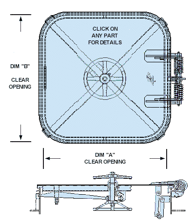
The scuttles were slightly bigger than a manhole. One normal 180 lb man could easily fit through. Put an SCBA and you could get through with some difficulty. They were dogged with a hand wheel that has bars/arms that come out. The scuttle itself was raised off the deck maybe 12 inches. This may not be the best description but I hope it will do.

[QUOTE=RespectMyAuthority;180101]The scuttles were slightly bigger than a manhole. One normal 180 lb man could easily fit through. Put an SCBA and you could get through with some difficulty. They were dogged with a hand wheel that has bars/arms that come out. The scuttle itself was raised off the deck maybe 12 inches. This may not be the best description but I hope it will do.[/QUOTE]

this is the type of scuttle RMA refers to (or so I believe anyway)

[QUOTE=c.captain;180103]this is the type of scuttle RMA refers to (or so I believe anyway)

[/QUOTE]
Similar but round

[QUOTE=Mat;180098]I would like to see a detailed, small scale version of the final positions with time stamps, so that we could determine when propulsion was lost, and see the drift pattern. Is anything available?[/QUOTE]

no because AIS reception was blown away by then and I do not know the position upload rate with LRIT but it is not continuous

      • Updated - - -

[QUOTE=RespectMyAuthority;180104]Similar but round[/QUOTE]

picky bastard!

[QUOTE=c.captain;180105]no because AIS reception was blown away by then and I do not know the position upload rate with LIRT but it is not continuous

      • Updated - - -

picky bastard![/QUOTE]

Doesn’t the Inmarsat have frequent polling that includes a position response?

Or or if necessary, what about having Inmarsat do a doppler shift analysis, similar to the Maylay Airliner?

[QUOTE=freighterman;180086]One thing I must admit I feel has been glossed over by this forum is the matter of the “scuttle” being open. KC has brought it up a several times, notably in post #68, along with an excellent elevation sketch of the ship. But I have yet to come across a long discussion on the subject of the scuttle. [/QUOTE]

I don’t have a good idea of how much water could get through a scuttle in a short time or how much it would take for 15 degree list. Both these things could be estimated.

With a low GM the ship would tend not to roll excessively in most sea conditions (tender ship will not match wave shape) but it would be vulnerable to synchronous rolling, parametric or rarely the broaching type high-speed roll. With a low GM the ship would take a large list in the event of asymmetrical flooding or a cargo shift. It’s possible that the list was not caused only by the water, maybe cargo shifted in another hold and the crew was unaware?

It does seem plausible that the flooding, the list and the loss of propulsion was a single event.

Another unknown is wind and sea conditions in that part of Joaquin. As Jamesbrown pointed out wind shifts over a short period of time/distance and high confused seas would be expected. How likely is it that the 10-15 ft seas is accurate?

Is it possible that the seas were 10-15 with a one time much larger set?

One unusual design feature of the EL FARO (and her sister ships) is that the upper-most cargo deck sticks out over the side of the hull. With the EL FARO’s design, the deck protruding over the side could act like a scoop, catching some of a large wave’s energy and adding to the rolling force in the opposite direction. I doubt that the possibility of this type of force is accounted for in their stability calculations.

I may have missed it…but is there a major position discrepancy on the last known ais position and the position where the el faro was found on the ocean floor? Would this indicate if the comms were indeed blown off the wh or just went dead near her resting final position?

[QUOTE=fullbell;180114]One unusual design feature of the EL FARO (and her sister ships) is that the upper-most cargo deck sticks out over the side of the hull. With the EL FARO’s design, the deck protruding over the side could act like a scoop, catching some of a large wave’s energy and adding to the rolling force in the opposite direction. I doubt that the possibility of this type of force is accounted for in their stability calculations.[/QUOTE]

Was that an original design feature or added at a later date?

[QUOTE=fullbell;180114]One unusual design feature of the EL FARO (and her sister ships) is that the upper-most cargo deck sticks out over the side of the hull. With the EL FARO’s design, the deck protruding over the side could act like a scoop, catching some of a large wave’s energy and adding to the rolling force in the opposite direction. I doubt that the possibility of this type of force is accounted for in their stability calculations.

[/QUOTE]

Windspeeds are getting worse, that’s National Geographic research funded by the National Science Foundation. Powerless and listing this old-fashioned design element would have been a contributor to making the deck awash I think.

[QUOTE=fullbell;180114]One unusual design feature of the EL FARO (and her sister ships) is that the upper-most cargo deck sticks out over the side of the hull. With the EL FARO’s design, the deck protruding over the side could act like a scoop, catching some of a large wave’s energy and adding to the rolling force in the opposite direction. I doubt that the possibility of this type of force is accounted for in their stability calculations.

[/QUOTE]

There was a discussion about how modern cruise ships appear “top-heavy”. On this ship that upper cargo deck gives the ship a imposing appearance in this photo. The freeboard deck being partly enclosed is visually deceptive.

[QUOTE=rshrew;180115]I may have missed it…but is there a major position discrepancy on the last known ais position and the position where the el faro was found on the ocean floor? Would this indicate if the comms were indeed blown off the wh or just went dead near her resting final position?[/QUOTE]

I don’t know about ‘major’, but the CG exhibit shows final position data (see link). It would be nice if a time stamp was laid down, and lat/lon… I’m taking the end of the blue line as the end of AIS info, but there is no reason to take that as gospel lacking any specific statement accompanying (maybe LRIT data?). It would be nice to have times so we could see those two slight course adjustments and how long between–possibly trying to improve the ride, maybe tried slight correction and due to insufficient result tried again?

The subsequent positions such as SSAS point activation may represent (with analysis) the period of time between loss of prop (end of blue line or nearabouts) and drifting while engineers try to recover before throwing in the towel leading to the Master’s calls noting they ‘can’t get it started’. The calls happened before the SSAS activation, noting the Master was going to ‘hit the buttons’ (so accounting for drift from his last reported position to SSAS). Modelling this drift, with weather data should provide a rough timeline for period of prop loss to eventual sinking. The potential amount of that time is not a pleasant one to consider regardless of duration.

(I give up on trying to copy and paste an excerpt–so, see slide 19, of CG Exhibit 001 here:

http://www.uscgnews.com/go/doctype/4007/286370/?offset=10)