[QUOTE=Kennebec Captain;180169]At this point we obviously don’t know the exact explanation and we may never know. Nobody could have possibly guessed the exact sequence of event that caused the crash of Air France 447but there were some suspicions that were on the right track. I think a list some of the factors that may have contributed could be made.
One set of factors would be the culture on board.
The crew probably was very good on that two port run but they would not have developed any skills dealing with unexpected complex problems that crew on a more a difficult run might.
Several reports that the captain was arrogant. He may have expected the crew to take a narrow view of their duties.
Crews on ships like that can get cliquish. The second mate ashore texting routing advice?
Another set of factors how the crew interpreted the weather information. On the JAX-SJU run the crew could have been very successful without a robust way of dealing with the weather. When the crew was asked how they got their weather the answer was that it came by email. I didn’t hear anything said about any other methods. A man with one watch is sure he knows what time it is, a man with three watches is not sure. Also the computer weather is convenient and fast but it can cause overconfidence in the accuracy and precision of the forecast.
Then the storm itself. Some characteristics of the storm, it’s track, the forecast, etc that made it difficult to understand.
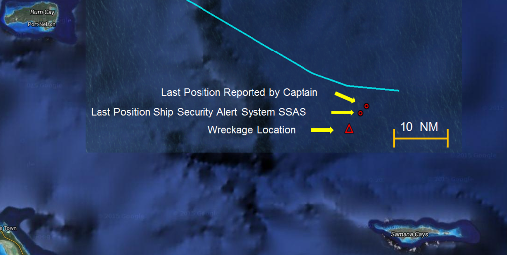
A couple of things in the hearing that were of interest: the fact that the weather was not sent up to the bridge when the captain was sleeping. The anemometer wasn’t working.
I think that the timing of the voyage might be important. If the weather was looked at on the 28th it [B]may have been dismissed as not an issue[/B]. The ship dropped off the pilot at about 2100, captain would have had a long day, messages to send. May or may not have had a quick look at Joaquin. Next morning it would have been past the optimum time to decide to use the Old Bahama Channel. The significant changes in the weather system the night of 30/01 would have been missed if the ship was set up to make weather routing decisions during the day by the captain only.[/QUOTE]
I will generally defer to the numerous ship masters here regarding genuine “ship stuff.” I’m not one and never will be, and won’t pretend to have expertise I don’t possess. But I do make weather decisions for my little 'ol wire boat and oil barge, I’ve had to do it for those very same waters, and I’m having real heartburn with the idea that El Faro’s master was just too damned busy to carefully look at, follow, and adjust for both the weather that was forecasted and the weather that occurred. As I (and numerous others) have pointed out previously, there was a named storm ahead before they even left port with environmental conditions primed to strengthen it. So with all due respect to ship masters the world over: for fuck’s sake, busy as I’m sure he must have been, if Davidson couldn’t give priority to the weather with Joaquin already out in front of them then when the hell WOULD he (or any other ship master) be inclined or able to do so? Is this practice of cutting it close to storms a cultural thing widely practiced by ship drivers? I understand fully that ships have speed that tugs don’t. Does that serve mostly to embolden ship masters in potentially dangerous ways? Would a higher manning standard, reducing the captain’s work load, help in theory and in fact?
So maybe a scuttle or hatch failed, or was left open. Maybe the cargo lashings were insufficient and the cargo got loose before it should have. Maybe the stability margins were tighter than they should have been. Maybe there were deficiencies with the propulsion system. Maybe the ship was too old, or maybe it just wasn’t adequately maintained. Maybe it was all of these things combined. Maybe there are lots of other possibilities we don’t know about and never will. No accident investigation is ever 100% definitive. Try as we might, they always have their own deficiencies and blind spots, like every other human endeavor.
I’m not looking to blame anyone in particular, per se. I’m not interested in attacking the man’s personal or professional character. I didn’t know him. But it seems to me that in this case the forensics aren’t going to yield much in the way of things like materiel or equipment failure, and even if more of that comes to light it will be of very limited value. It seems to me that focusing on fully understanding the thought and decision-making process, both afloat AND ashore, that led to El Faro ultimately pulling up lame in front of Joaquin is where the buried treasure is.
Exactly what weather information did they use, and why? Why was that route chosen and adhered to despite the forecasts and unfolding events? How often did El Faro receive updated wx information? If it didn’t go to the bridge when the master was asleep, why? Did shoreside managers normally monitor the voyages of any of their vessels and the weather that affects them? If so, to what degree? Would higher-risk voyages get more (or any) scrutiny from ashore? Does it depend on the specific vessel and/or master? If not, why? Did the shoreside managers monitor that particular voyage? If so, were they simpatico with the routing? If so, why? If they weren’t, did they attempt to do anything about it? Or were they oblivious to the unfolding disaster until the first phone call from the master? What specific resources were available to the master before departure and while en route? Were/are masters always simply left completely to their own devices and choices, regardless of any other considerations, with no particular monitoring of any kind? If so, is that a good way of operating a ship, or any other kind of vessel? Yes, the last two questions are rhetorical.
We may never get entirely honest or accurate answers to those questions, but I think if merchant mariners are interested in avoiding personal involvement in some version of a repeat performance it’s where the focus needs to be. We’re all fallible. If that inevitable fallibility isn’t recognized and factored carefully into our decision-making processes in all parts of voyage planning and execution then it should come as no surprise when it happens the next time. And of course there will always be a “next time.” It’s just a matter of who, when and where.

 [/QUOTE]


