El Faro - What was the Captain Thinking is the Wrong Question

[QUOTE=Jamesbrown;195694]

01OCT/0445: CM ‘down to nine sixty millibars’

[/QUOTE]
By then it was way too late to take any evasive action. I was thinking more of way back the previous afternoon. The Capt was on the bridge and listens to the NHC Hurricane warning for San Salvador & Rum Cay broadcast on USCG VHF at 14:15. He exclaims “Wow.”, but then doesn’t seem to make any added effort to analyze the imminent danger of the situation. If at that stage they had been able to monitor wind & pressure data closely, they would have had a better idea of the severity of the situation, and would have had time to respond.

In fact the evidence from the transcript suggests he doesn’t even talk to the Captain of El Yunque, when they pass 35 minutes later. The CM’s communicate on VHF, but their conversation is frivolous, about light bulbs and tarps. The weather is mentioned briefly, but mostly treated as a joke. When the El Yunque Capt takes over and talks to the El Faro CM they don’t even mention the storm.

Before 01/0400 hrs the captain apparently believes he is going to pass south of Joaquin, presumably based on his BVS program which is in error, at what expected distance off is not known. The BVS file did not update properly so the forecast did not update. A correct NHC forecast may have been sitting on the GMDSS printer.

In fact the ship was approaching the eyewall on the north side. It’s absolutely standard practice to check to see if the weather encountered matches the forecast. The barometer is of less use because approaching the dangerous semicircle or navigable, in either case the barometer is going to be falling. At night the best indication of the location of the ship in relationship to the center of the system is wind direction.

His observation of wind and barometer data appear to have been serving as means to let him know when it would be over more than precisely maintaining a safe distance in response to storm movement.

After 01/0400 hs, there was an attempt to put the wind on the opposite side to heel the ship, far too late to maintain a safe distance:

okay what I’m gunna do– I’m gunna turn the ship
and get the wind (on the north side) right there and
get (it going) more (in that) direction get everything
on the starboard side give us a port list and (um
see) if we’ll have a better look at it.

Maneuvering a big ship with a large sail area at night in the wind it’s helpful to see when bow crosses the eye of the wind.

Evidently at this point apparently he still believed he was in the navigable semicircle and the system was moving away and the weather was going to improve. In fact the eyewall was approaching and the situation was going to worsen.

Here’s the conversation- seems like they may have believed they spotted the eye wall to the north, where they expected it.

CAPT
05:17:02.1
05:17:04.0
alright. do you see what I see?
CM
05:17:04.3
05:17:05.4
yes.
CM
05:17:05.9
05:17:08.6
(the band I see) is to the north of us.
CAPT
05:17:08.5
05:17:09.0
correct.
CAPT
05:17:11.7
05:17:14.1

      • (around the stack).

05:18:37.1
05:18:39.1
only gunna get better from here.
CM
05:18:38.5
05:18:39.0
yup
CAPT
05:18:39.4
05:18:41.8
we’re on the back side of it.

They were not on the back side of it and things were not going to get better.

From Bowditch

  1. Locating the Center of a Tropical Cyclone
    If intelligent action is to be taken to avoid the full fury of a tropical cyclone, early determination of its location and direction of travel relative to the vessel is essential. The bulletins and forecasts are an excellent general guide, but they are not infallible, and may be sufficiently in error to induce a mariner in a critical position to alter course so as to unwittingly increase the danger to his vessel. Often it is possible, using only those observations made aboard ship, to obtain a sufficiently close approximation to enable the vessel to maneuver to the best advantage.

The winds are probably the best guide to the direction of the center of a tropical cyclone. The circulation is cyclonic, but because of the steep pressure gradient near the center, the winds there blow with greater violence and are more nearly circular than in extratropical cyclones.

At 14:15 by VHF from a Coast Guard aircraft:
NHC Hurricane Warning for the Central Bahamas: Rum Cay, San Salvador…
NHC Hurricane Watch for the whole Northern Bahamas: from Bimini to Abaco.

The ships position at that time was off Abaco, heading to San Salvador.

Did they confound hurricane Watch and Warning?
The Warning is nearer to the center and more precisely extrapolated than the Watch.

After the VHF transmission:

2M: so hurricane Warnings for– ohhh exactly. [sound of chuckle]

CAPT: yeah

2M: Abaco Island [I]{…where they were at that time; there was a Watch only}[/I]

CAPT: yep. they have all those right here written up.

…a minute later
CAPT: so– by two o’clock– on your watch– you should be south of this monster [I]{ 2 am ?} [/I]

2M: yeah it seems like we’re gunna get through it pretty quick. by uh tomorrow afternoon– should have it all [I]{…her next day-time watch ?}[/I]

It seems, they estimated Joaquin much nearer and going North, hence not that strong…
That could be the cause of the later confusions about wind directions and the “conflicting forecasts”.

At least, I read it this way…

[QUOTE=Earl Boebert;195692]Stop or go? Lots of cultural and organizational pressure to go; so much so that rolling the dice becomes the default option and stopping must be justified – especially if the individual has rolled the dice in the past and won.[/QUOTE]

This exactly! This is the cause of almost every major incident from ships sinking to space shuttle explosions.

The lack of urgency from the Captain in particular and the bridge in general points to the fact that as K.C. says, they were being guided by the BVS weather program, which had out-of-date information. It seems they were so reliant or trusting of this input, that they neglected to adequately monitor and assess their own weather observations.
I know from experience, having been mid-Atlantic in 50 kts of wind when no forecast or weather chart showed anything of that strength in the area, that sometimes your vessel’s weather data is the most accurate in your vicinity. In remote offshore locations, the forecasters rely on on a few ship’s reporting weather data, coupled with satellite and computer generated input. That can mean your own vessel is the best tool for assessing a developing storm at sea.
I once crossed the Atlantic with the UK meteorologist Peter Cockcroft, who had arranged with the UK Met office to email the vessel’s weather observations via sat phone as we crossed. He would send off the data to Bracknell, who would then upload it to the web. Half an hour later we could then download the latest weather fax from NOAA on our SSB radio, which would include our call sign and a wind arrow on their chart in our location. This shows how much the weather service values the observations of individual ships when out at sea.
There were very few vessels out in the vicinity of the developing storm that night. The hurricane hunter planes were the best on-the-scene weather tools available. But the El Faro should have been able to use its own weather observations to work out that things weren’t going as planned. Once the 14:14 Hurricane Warning for San Salvador & Rum Cay was heard on the bridge, they should have been proceeding with extreme caution, not barreling along at full speed without really investigating the chance that they might not be able to make it through ahead and south of the centre.
I remember that the Curacao Pearl left Charleston, SC. at about the same time El Faro left Jacksonville. Their normal route was straight down to Puerto Rico, through the Mona Passage, and on to Trinidad. On this voyage however they left the US and steamed pretty much on their usual route out to sea for about 12 hours, but then crucially made a decisive course change to the south, that subsequently sent them through the Old Bahama Channel. Of course their cruising speed was half that of the El Faro (12.5 kts), which would have influenced their decision. But it would have been interesting if the Hearings had requested a transcript of bridge communications from the Curacao Pearl, in order to see what kind of discussions were had regarding the change in course.
The El Faro disaster highlights an irony that perhaps too much smart technology and an over-reliance on third party delivery of weather information made possible by advances in communications may have ultimately contributed to the ship’s fatal error in course. If the ship had sailed without any knowledge of the developing storm, as a vessel would have done 200 years ago, they would have taken their usual course out to sea. But a ship from that era would likely have had mariners aboard capable of reading the local weather conditions observed as the vessel proceeded SE, and, according to the principles of Bowditch, would have got wise to the likely monster lurking ahead and taken evasive action.
Possibly this incident will become known as a tragic example of how too much technology (and certainly dependence on out-dated and erroneous data) can contribute to a dangerous feeling of complacency and invincibility, that can sometimes produce worse results than having less information (but more knowledge) and proceeding more cautiously as a result.
This leads back to the issue of whether news channels broadcasting model runs of future tracks for storms as if they are infallible do more harm than good. Had the general consensus NEVER been that this developing tropical depression was certain to track north, rather than move south to the Bahamas, it is unlikely that the plan of dodging south of the storm would ever have been formulated. The system was still moving SW. If there were no models showing it slingshot off to the north, no ship would have deliberately headed SE towards it. This was a massive failure of the integrity of the models, and the only wise conclusion should be: [B]Never base a sail plan on a wishful model forecast if the actual direction of the system is still physically headed towards the location you are planning to go. Delay heading into that danger area until there has at least been some consistent movement in a contrary direction which shows that the model forecast is showing signs of being correct.[/B] This should be a Golden rule.

[QUOTE=Mat;195726][B]Never base a sail plan on a wishful model forecast if the actual direction of the system is still physically headed towards the location you are planning to go. Delay heading into that danger area until there has at least been some consistent movement in a contrary direction which shows that the model forecast is showing signs of being correct.[/B] This should be a Golden rule.[/QUOTE]

how simple this is and how easy to apply. pull the throttles back a half dozen knots to allow the storm to settle on a track and only then go back to full ahead once the ambiguity is resolved. I say it over and over and over…there are virtually ZERO dangerous situations at sea which cannot be made safe (or at least safer) by simply slowing down. How much time will be lost in slowing down depends on the circumstances but we are not talking about the need for a whole new route with increased distance. Only making the total time on the existing track just a little more. If EL FARO had dropped to say 16kts at 1800 the evening before it was lost, the extra distance purchased between it and the center of Joachim would have been the margin between life and death for the ship and all those souls. Late arriving in San Juan but intact. Either TOTE intimidated the master to keep holding on everything else be damned or the master had ZERO wisdom about the dangers of such a storm. Can’t be anything else.

Lots of talk about Anemometer and the ability of Officers to assess the wind force and direction without it.

In my sailing days in the South Pacific and S.E.Asia we relied on our own observations, since there were very little else to use. (No Satcom, Navtex, WxFax etc.)
There MAY have been a hand held anemometer at best, but usually licking on the finger were the nearest to any “tool” available. That and observing the waves and compare that to the description in the “Beaufort Wind Scale & Sea State” poster: http://www.seakayak.ws/kayak/kayak.nsf/7fa3095d976a5b7c8525711d006d6667/e4e2c690916a3a24852570da0057e036!OpenDocument

When navigating in areas with reefs, or approaching an island or coast, we would also watch for changes in motion of the ship due to backwash and eventually listen for the sound of breakers.

Stability was judged by roll period and you kind of “felt it in your little toe” before it became critical.

Unfortunately those skills are probably dead among commercial seafarers, who seldom look up from their screens to see the real world around them.

Having the ability to combine the use of modern information with the old methods have served me well, even in the Offshore setting.

Great link ombugge - Thanks

[QUOTE=ombugge;195732]Lots of talk about Anemometer and the ability of Officers to assess the wind force and direction without it.

In my sailing days in the South Pacific and S.E.Asia we relied on our own observations, since there were very little else to use. (No Satcom, Navtex, WxFax etc.)
There MAY have been a hand held anemometer at best, but usually licking on the finger were the nearest to any “tool” available. That and observing the waves and compare that to the description in the “Beaufort Wind Scale & Sea State” poster: http://www.seakayak.ws/kayak/kayak.nsf/7fa3095d976a5b7c8525711d006d6667/e4e2c690916a3a24852570da0057e036!OpenDocument

When navigating in areas with reefs, or approaching an island or coast, we would also watch for changes in motion of the ship due to backwash and eventually listen for the sound of breakers.

Stability was judged by roll period and you kind of “felt it in your little toe” before it became critical.

Unfortunately those skills are probably dead among commercial seafarers, who seldom look up from their screens to see the real world around them.

Having the ability to combine the use of modern information with the old methods have served me well, even in the Offshore setting.[/QUOTE]

Right on. How’s the unmanned ship with judging the feeling in the little toe? Any ability to look up from the screen?

[QUOTE=Emrobu;195739]Right on. How’s the unmanned ship with judging the feeling in the little toe? Any ability to look up from the screen?[/QUOTE]

Silly questions. There’s nobody there.:confused:

I wonder whether there was a weather fax on board the El Faro, I cannot remember having seen any reference made to this equipment. For the Caribbean area regular weather faxes are scheduled by the National Hurricane Center’s Marine Radiofax Broadcast service via New Orleans, LA call sign NMG. These messages are updated frequently by also the data collected by dropsondes parachuted into the eye of the hurricane. That tricky job is done already since 1944 by the famous Hurricane Hunters.

These charts could be a very helpful means indeed to mariners in the case of hurricane navigation, especially since the number and intensity of tropical storms and hurricanes have increased considerably since the 80’s due to the warming of the earth. As a result tropical storms and hurricanes can nowadays also be found below the latitude of 15° north which was not the case in the old days.i

Both Mat and Dutchie make the same point, more expertise applied to the routing problem may have been needed. But the decision making structure has to be looked at.

As it is the captain evidently feels the need to get approval to divert but no approval is needed to take on increased risk. Because of this dynamic the system is biased towards more risk. Instead, in cases of elevated risk from weather the captain could be required to submit his avoidance plan ashore for approval based on some rule-based approach.

For example if a captain could be required check to see if his route violated something like the 1-2-3 rule and if the rule was violated he’d have to submit his voyage plan to a higher-up ashore. If the plan was approved by someone with real weather-routing experience then they’d be approved to go but with some kind of systematic monitoring to make sure the plan was on track as the voyage progressed.

The more I read of the transcript and the analysis here, I can’t but help remembering Conrad’s “Typhoon”. . . .although the end result is certainly different. . .

[QUOTE=cmakin;195750]The more I read of the transcript and the analysis here, I can’t but help remembering Conrad’s “Typhoon”. . . .although the end result is certainly different. . .[/QUOTE]

There does seem to be something, maybe odd going on. Captain almost seems to be deflecting concerns. At one point on the 30th (I think just before watch change at about 0750) the Sat-C spits out a message, the mate says something along the lines of there’s the latest but the captain seems to want to direct attention back to the BVS results.

Also the captain reliably brings up Alaska weather as if to minimize concerns.

[QUOTE=Kennebec Captain;195752]There does seem to be something, maybe odd going on. Captain almost seems to be deflecting concerns. At one point on the 30th (I think just before watch change at about 0750) the Sat-C spits out a message, the mate says something along the lines of there’s the latest but the captain seems to want to direct attention back to the BVS results.

Also the captain reliably brings up Alaska weather as if to minimize concerns.[/QUOTE]

As I wrote earlier:

It looks like a case of narrowing reality or tunnel vision, setting aside all threaths and focusing on a certain fake reality, with in this case a disastrous end result.

The deflecting of concerns fit into this phenomenon. In this state of mind you allow only information that supports your way of thinking, everything else is ‘deflected’ as you call it. In view of all the absurdities and contradictions in this mess I never understood why they didnot consult a psychologist of name during the hearings to help explain the captain’s behaviour. Maybe it is still not too late to do this…

0510: Capt: ‘now we’re on the back side of the storm’. (which he repeats at 0518)
At about the same time: only gunna get better from here

[QUOTE=ombugge;195732]Lots of talk about Anemometer and the ability of Officers to assess the wind force and direction without it.

[/QUOTE]

This is absolutely not about the ability of the officers to assess wind velocity without an anemometer.

Had the captain told the watch officers that there was uncertainty with regards to the location of center of the tropical cyclone and it was critical to monitor wind direction, no doubt they could have provided the needed information. However evidently the captain was certain of the location of the center and apparently did not see any need for the bridge watch to monitor the weather.

Had the captain felt that monitoring of the weather by the bridge watch was important in the first place likely he would have made a greater effort to have anemometer repaired.

[QUOTE=Kennebec Captain;195756]This is absolutely not about the ability of the officers to assess wind velocity without an anemometer.

Had the captain told the watch officers that there was uncertainty with regards to the location of center of the tropical cyclone and it was critical to monitor wind direction, no doubt they could have provided the needed information. However evidently the captain was certain of the location of the center and apparently did not see any need for the bridge watch to monitor the weather.

Had the captain felt that monitoring of the weather by the bridge watch was important in the first place likely he would have made a greater effort to have anemometer repaired.[/QUOTE]

Didnt’ he?

Instead of your last, I would say, Had the Captain felt that the bridge watches’ ability to monitor wind direction and speed inadequate, he likely would have made more of an effort.

But he clearly felt that monitoring the weather was important as noted in his instructions of 30 Sep/1317:

Capt 13:17:04.8: From here-here out log the weather, just um wind direction and force, barometer every hour.

Capt 13:17:14.3: Keep an eye on this I mean I know it’s in a lull

Capt 13:18:20.0: no, no, no, no I don’t necessarily need the temperature… the barometer

In terms of communicating uncertainty, I think he did, and certainly the 3M and 2M calls indicate they felt able to make observations on storm movement when they had info.

In any case, he did have them do hourly logs monitoring weather (wind speed force baro) and reviewed them and noted uncertainty in the storm action aloud. See 30 Sep/14:02 and after and note also his comment, “we’ll just have to watch it, there’s not much we can do (but they) the weather pattern itself is crazy erratic”.

With regard to an early comment of yours, KC, “almost seems”? How do you feel the transcript fails to support his minimization of weather impacts as a risk? I would consider his minimization of the threat posed by weather to anything but making way is key to his monitoring of the storm movement in less than line-by-line adherence to Bowditch recommendations.

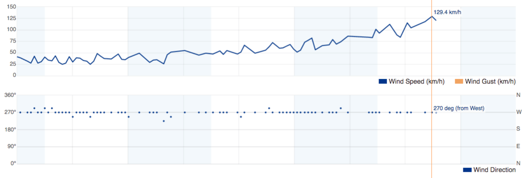
Weather History Graph for Crooked Island And Long Cay
September 30, 2015 - October 1, 2015

This graphic from the closest weather station to Sumana Cay illustrates how easy it would have been to work out that they were going to get a direct hit. The weather station [ICROOKED2] was knocked off air shortly after the 129.4 km/h reading. The pressure was falling steadily since midday the previous day; wind speed steadily increasing; wind direction constant (no veering or backing). They were clearly in the direct path of the storm.
If El Faro had been able to see their own graphic for the same period it would surely have set off more alarm bells.

The situation with regard to assessing the location of the storm brings up the distinction between systems that are safety-critical and systems that are safety-relevant. A malfunction in a safety-critical system will generally directly lead to an accident (e.g., fly-by-wire control system.) A malfunction in a safety-relevant system will be a factor in an accident only if that malfunction misleads the operator into making the wrong decision. Safety-critical systems get a lot of attention, safety-relevant systems much less. The problem we seem to be having these days is that individuals are becoming so dependent on nominally “advisory” systems that those systems become, in effect, safety-critical.

The distinction was brought home to me many, many years ago when I was part of a team that developed a (ultimately unsuccessful) system for the DC-10 called Pafam. This thing used software to correlate various instruments and provide a display that showed the pilot his touchdown point in a low-visibility landing. Back then the FAA had no process for certifying software so the project was dead if the device was deemed flight-critical. Big meeting, FAA, NASA, chief pilot of Northwest Airlines, me in the back of the room with a stack of viewgraphs describing how we validated the software. Never got to present, because after an extended and somewhat heated discussion the FAA decided the device was only flight critical if the pilot believed it, and it was the duty of a command pilot to be skeptical of what the instruments were telling him. We seem to have drifted away from that attitude.

Earl

1 Like