The captain told NTSB investigators he knew there was an uncharted rock in the area he was navigating, but he believed it was closer to shore. He said on previous fishing trips, during a “really low-minus tide,” he saw the rock, but did not mark it on his charting software.
The USCG is not big on proactive changes that increase safety. The NTSB has recommended many changes over the years but few have been heeded. Regulatory capture comes to mind,
The threshold for a NTSB investigation is a $500,000 loss. In this case the loss was $600,000.
The report provides a little “slice of life”, so to speak, for those of us outside that sector of the industry.
One thing I found interesting in the report, it illustrates how fisherman often work with small margins of error, balancing one risk against another. In this case working close to shore to avoid higher seas. This contrasts with the approach used by larger vessels, the advice in the Coast Pilot is to stay one mile offshore.
It’s another reminder that there are still areas of the world where the charts can not be implicitly trusted, where local knowledge is required to navigate safely. Also the weakness of using one’s memory rather than recording the position of uncharted hazards when they are discovered.
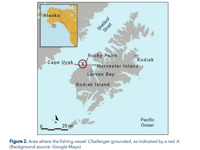
I’m not sure about the details. The report says the boat was drawing 4.5 feet in water 25-30 feet deep but on the chart it looks like the grounding was near the 20 meter contour which is 65 feet of water.
I wonder if there are any plans to survey that area? Or publish some kind or local notice to mariners? Or perhaps there are other areas with higher priority?
Just a few of the caveats listed in the Coast Pilot 9:
(27) Under-keel clearances
(28) It is becoming increasingly evident that economic pressures are causing mariners to navigate through waters of barely adequate depth, with under-keel clearances being finely assessed from the charted depths, predicted tide levels and depths recorded by echo sounders.
(29) It cannot be too strongly emphasized that even charts based on modern surveys may not show all sea-bed obstructions or the shoalest depths, and actual tide levels may be appreciably lower than those predicted.
(99) In coral regions and where rocks and boulders abound, it is always possible that surveys may have failed to find every obstruction. Thus, when navigating such waters, customary routes and channels should be followed, and areas where irregular and sudden changes in depth indicate conditions associated with pinnacle rocks, coral heads, or boulders should be avoided.
(100) Information charted as “reported” should be treated with caution when navigating the area, because the actual conditions have not been verified by government surveys.
and my personal favorite, repeated numerous times for various locations:
Mariners should exercise caution navigating these waters. Numerous shoals and rocks bare at minus tides because of an uplift of about 11 feet caused by the March 1964 earthquake.
Not to my knowledge. Fishermen would probably actively lobby against detailed surveys of some of these areas, as many of them have personal bathymetric charts generated by rather expensive equipment.
You get a feel for where the chart can be trusted and where it cannot. This is why I don’t care about the limitations of raster charts. If I don’t have a generated bathymetric chart the inaccuracies of raster charts are the least of my problems.
This is far from the most dangerous inaccuracy I have seen. You should know not to trust the depth curve in any area remotely similar in topography.
I was surprised to learn from a discussion here that many mariners implicitly accept the idea that the charts are accurate. However beliefs of this type are very common, you don’t know what you don’t know.
I learned navigation in Alaska and spent a good part of my early career working there. So, over time from observations, anecdotes and so forth I picked up on the idea that charts could have errors.
Mariners who learn their trade in different regions might develop an implicit “established belief” rooted in the notion that charts are consistently reliable. This belief becomes ingrained over time and can lead to an unexamined, implicit trust in the accuracy of nautical charts.
I moved to AK from an area that was well surveyed and well travelled on the east coast of the lower 48. I was one of those people who trusted charts. When I started working in the dive fishery in AK a skipper told me “Don’t TEST the chart around here.” He then proceeded to show me some areas where the depth was way off, charted rocks didn’t exist, and some spots where rocks existed that weren’t charted. Then there are all the “local names” for anything and everything. It was eye opening.
When chart inaccuracies are just a theoretical, abstract concept the idea doesn’t really sink in. It’s another thing when working where it really matters. Anecdotes, aka sea stories can have real value.
Than there’s jokes like this:
Fisherman 1: “Hey Joe, better watch it in there, lots of uncharted rocks.”
Fisherman 2: “Don’t worry, I know where the rocks are in here.”
Fisherman 1: “Yeah, sure you do, because you’ve hit most of them!”
The Coast Guard, being the red-headed step-child of the US military is always struggling for funds. Example, the task of building ONE heavy icebreaker. The Coast Guard’s duties are so wide and varied just carrying out their standard duties can be difficult, IMO.