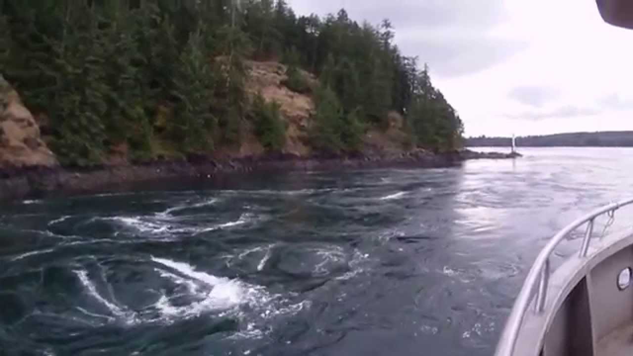
Seymour Narrows B.C Canada

Seymour Narrows - Wikipedia Article

From WIkipedia:
Hydrology

Seymour Narrows is notable also because the flowing current can be sufficiently turbulent to realize a [Reynolds number]i.e. one hundred million, which is possibly the largest Reynolds number regularly attained in natural water channels on Earth (the current speed is about 8 m/s, 26 ft/s, the nominal depth about 100 m, 330 ft).[4] Turbulence develops usually around a Reynolds number of 2000, depending on the geometric structure of the channel.

2 Likes

From Coastal Transportation’s training manual for new navigators:

…Seymour Narrows is one of four salt-water rapids which mark the divide of tidal influence between the Strait of Juan de Fuca to the south and Queen Charlotte Sound to the north.

For the navigator this concept means that the directions of ebb and flood on one side of the divide is opposite that on the other side, something to be kept in mind when working predictions of tidal currents. And the salt water rapids themselves, though short in length, are highly turbulent and constitute the chief danger on the Inside Passage. At full current the surface of the rapids will appear to be boiling with cells of whirlpools.

All traffic on the Inside Passage is timed to the four daily slacks of this line of salt-water rapids along the northern rim of Desolation Sound.

Seymour Narrows is the only one of these rapids permitted by company regulation to Coastal Transportation vessels. The other rapids are too small for routine navigation by our vessels. They consist of Yuculta Rapids, Surge Narrows/Okisollo Rapids, and Hole-in-the Wall/Okisollo Rapids. The only company use of the smaller rapids is by the training boat for training new navigators in tidal hydrology.

CTI vessels must only use Seymour Narrows at or near slack and when the predicted velocity of the water does not exceed the ratio to vessel speed specified in the standing order Seymour Narrows Transits.

The slack at Seymour is notional. The current never really stops. Consider it one giant eddy composed of small eddies and whirlpools which at slack change direction in a complex pattern over a few minutes.

Non-displacement vessels have little trouble with this confused water. Coastal freighters, tugs, and cruise ships are continually spun off course even during ‘slack’.

Going through with the tide behind you reduces your ability to maneuver around opposing traffic. Trying to stem a strong current decreases your chance of forging through before the current exceeds vessel speed, forcing the ship backwards. Reversing course at that point can result in a maneuver throwing the vessel in risk of collision with opposing traffic.

Because commercial traffic uses the narrows almost exclusively at slack, miles-long traffic jams of vessels can line up on either side of the 1/4 mile long narrows timing passage to slack, and all passing through within a short window of time. These include everything from log tows, cruise ships, yachts and kayakers…

12 Likes

And all of this is after they blew up the primary hazard, which was Ripple Rock– located right in the middle of the narrowest part of the channel. This was back in 1958 when you could blow big things up as a public service. At the time, it was the world’s largest non-nuclear explosion. Then the Oregon Public Works guys said “hold my beer” and blew up that dead whale on the beach. Both great videos to watch.

4 Likes

I have experienced a similar scenario, vessels stemming a strong current, but not because they were late but when they were early. That is when the strength of the current against was decreasing.

We were northbound approaching the narrows and a tug towing called me and said they were ahead of us and doing 4 kts. We were doing 12 kts and I stepped it off with dividers and figured the tug would clear before we got there.

What I didn’t figure was what would happen when the northbound tug and tow hit the last of the flood tide. When we got to the narrows I found that the tug was very slowly stemming what must have been close to a 4 kt current. Got by okay but my confidence took a reality check.

5 Likes

Trying to maintain spacing with the other guys while towing can be a real bear. Once you get north of Cape Mudge, you can only go so slow before worrying about your wire on the bottom. Then, a round-turn is your only option. Pre AIS, the pilots on the cruise ships in the summer time would tell some terrible lies about their speed and eta’s to Maud Island just to have no competition for the Narrows. Now you can see exactly where they are, and they can’t bully the poor tug boat man any more.

4 Likes

We used to run Seymour Narrows back in the 90’s when I was on tugs. We used to get up there and wait for the tides but a lot of Canadian commercial fishing boats would through at any tide. It was impressive to watch them do that. Even at slack tide we would have our tow all over the place. We used to go up to Wrangell, AK, absolutely beautiful. There used to be a Lighthouse around there where the Lighthose keepers daughter was in a Playboy. Come to think about it, She was absolutely beautiful too…

1 Like

A waterwheel hooked to a generator? Something to think about. :grin:

1 Like

My mind has been occupied for many quiet hours on watch by that notion. Sub-surface? Why not? Why not other places in BC and Puget Sound?

1 Like

There’s a lot of it about - Orkneys, N. Ireland! e.g….

Underwater turbine spinning for 6 years off Scotland’s coast is a breakthrough for tidal energy | AP News

2 Likes

Northbound, I usually enter at Cape Mudge 2 hours before HW Slack at Ripple Rock. I’ll be bucking a strong current at first, but can avoid some of it once inside by favoring Quadra Island. That puts me at Ripple Rock at about HW Slack with a favorable ebb thereafter.

2 Likes

Sounds like there’s a lot more traffic on the inside passage (IP) then when I was there last. ( Some years ago—never mind how long precisely)

Seymour Narrows is a choke point that concentrates traffic. The City of Campbell River is much bigger than it used to be with a lot more recreational boats. There is also some local tug and barge traffic that concentrates around slack water. A lot of Cruiseship traffic during the season. We didn’t have so much of that years ago. However, there are a lot less commercial fishing boats now than years ago.

Overall, the Inside Passage is still sparsely populated and has little traffic.

2 Likes

So there I was, a nervous mate on the dark watch with a captain who had no interest in being disturbed. Southbound in Discovery Passage for the Narrows, and I see clearly on my radar a solid contact up the way in the center of the Narrows. I watched him for a bit, then started calling on the radio when he just seemed to stay in the narrow spot. I battered the airwaves on every vhf channel I thought might yield results to find out what this guy was doing, and make arrangements. I scanned the opening where he should be with the binoculars, but couldn’t see a thing. The current was behind me, so I was inexorably southbound. Only a few tenths of a mile away, the radar blip disappeared, and I sailed down without incident. In the heart of the narrows, I went out onto the bridge wing to look for this guy, who might be still lurking out there, and I looked up to notice big metal balls hanging on the power lines stretched across the water. I don’t really know what the purpose of those balls was, except to initiate young mates.

5 Likes

Were these balls strung along the tops of the power cable masts? Helicopters often use roads and waterways for navigation. Power lines are fiendishly difficult to spot from the air which results, from time to time, in fatal accidents. Thus power lines crossing rivers or major roads are often marked with balls (in our area they are generally painted red/white to improve visibility). Could your “ghost objects” have been something like this?

EDIT: Low hanging powerlines can interact with shipping, too. A few years back, a crane on a barge doing construction work on an inland waterway in Germany severed a major high voltage line (although it was marked), leading to power outages and prolonged obstruction of the waterway. Fortunately, no fatalities.

IIRC, the Strait of Messina had overhead cable crossing with such aerial marker balls, and was noted in the Planning Guides I’ve previously mentioned as showing up on ships radar screens.

1 Like

Yes. A radar reflection of what are mean to be visual warnings for pilots, marking the power lines that cross the narrows there. In another place in the Coastal Transportation Vessel Operation Manual there is an article warning new navigators of the ‘phantom target’ phenomenon. Usually strongest in fog for some perverse reason.

A well tuned radar on short range in calm weather with the rain turned off and sea clutter turned low may show birds, current boils , tide rips, and even flipping schools of fish “raining” on the surface.

if the sea clutter is not turned all the way down, those types of targets may disappear as you get closer to them.

3 Likes

Google first post later

I’m sure that must have been my ghost vessel. They did become invisible to radar over time, so maybe they got changed to plastic or fiberglass?

For obvious reasons, these marker balls have been made of non-conductive materials from the very beginning.

Materials evolved from glass (heavy and prone to breaking), to glass-fibre reinforced plastic, to polyurethane or polyethylene, over several decades. None of these materials are highly reflective to radar.

However, the glass and early brittle GRP was stabilized by inner metal scaffolding that may have increased radar ping. Reports of radar appearance of the marker balls seem to ebb from the 1980ies onward…

1 Like