Sea Star's El Faro

[QUOTE=+A465B;170843]

The US merchant marine is a small community of a few thousand, subdivided further by coast, trades, ship types, unions and schools. The people come from a few geographic areas, in general, even specific islands. Not all, but this
is how it stacks up.[/QUOTE]

So true. Here is a good piece of journalism on the life of a merchant mariner.

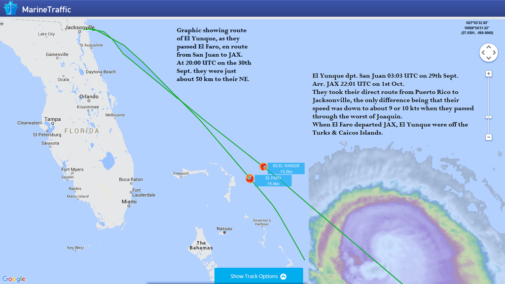
Graphic showing the course taken by El Yunque when they passed through Joaquin en route from San Juan to Jacksonville. Shows that they were within about 50km of El Faro when north of the Bahamas, having sailed through the storm.

[QUOTE=Reginald Strainworth III;170846]So true. Here is a good piece of journalism on the life of a merchant mariner.

http://www.cnn.com/2015/10/06/opinions/george-el-faro-ship-workers/[/QUOTE]

long time lurker first time poster, Youā€™re not going to find much love for Rose George on here, and for good reason.

[QUOTE=Reginald Strainworth III;170846]So true. Here is a good piece of journalism on the life of a merchant mariner.

http://www.cnn.com/2015/10/06/opinions/george-el-faro-ship-workers/[/QUOTE]

Long time lurker, first time poster. Not going to find much love for Rose George on here and for good reasonā€¦

Thats the AIS report I asked for yesterday. Thanks for that. Will be interesting to see what their discussion was.

[QUOTE=+A465B;170714]Mat,

Those are nice, much appreciated and shared thoughts.

You post the maps, and my question is - what was the forecast at the time? A storm track to the SW? A turn to the NW? A turn to the NE?

The forecast track and intensity [U]at the time[/U] is important, not just the relative positions of the storm and ship ā€¦

This information would form part of the decision making process, similar to what Kennebec Captain already sees. Storm off to the SW, plenty of sea room to the eastward ā€¦ Storm not doing that, crap, can we make the turn and shoot the gap through the islands?
Quick turn to the NE / NW, perhaps we are okay as it is. The shipā€™s course change suggests something.

You seem good with the maps. How about an hour by hour sequence of the ship track, the storm track AND an extract of the NHC forecast at the moment of theseā€¦ a bit of research well worth it, because it will give little clarity. Iā€™m sure the official investigation is well on to this line of thought, with added info from the company.[/QUOTE]

The course change according to these diagrams isnā€™t very significant IMO

[QUOTE=valvanuz;170723]Well here is a glimpse. I have put on NOAA charts forecast on 09/30 at 08:00AM the ship approximative position (based on Marine Traffic AIS) on 09/30 at 08:30AM

On route from Jacksonville to San Juan, what would YOU do?[/QUOTE]

Head SSW towards Miami!

[QUOTE=Mat;170800]Hi, Iā€™m Mat! The one who posted the graphics?!
QuabbinHiker is Mike. Mat is Mat. Its really not that complicated!
I see Mike posted some good graphics from Jeff Masters, who is very good at this stuff, and very experienced with Tropical stuff.
I will see if I can work on finding the forecasts and match them against actual tracks and ship positions as well (no promises)
My theory is that, in general, looking at the models and track forecasts, and giving them more weight than they rightfully deserve, can skew the passage planning process. I wrote an article published in the June issue of Caribbean Compass which looked at Hurricane preparations for yachts staying in the islands during the storm season, in which I suggested that when faced with an approaching storm you should "[I]first make one version of your preparation plan based solely on the actual conditions reported in the NOAA advisories, rather than based on any forecast or forecast track. So you assume the continued forward movement of the storm will be on its current track (plus or minus 5 degrees). You also assume that the storm will develop progressively (the farther away, the more potential for development), disregarding any forecasterā€™s predictions that conditions are not favourable for intensification. With this plan composed, you can then start assessing forecasts and track models, and weigh up your options accordingly.[/I]"
I believe that computer model tracks showing movement of a system in completely the opposite way to which it is currently moving do not help anyone make an informed decision as to where it is safe to proceed. In such a case it is only prudent to consider the continued forward movement of the system, until such time that a significant change in direction occurs.
Article link: http://www.caribbeancompass.com/hurricanes_windwards_2015.html
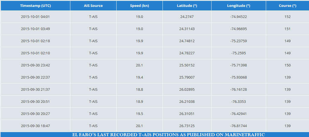
Iā€™ll just post the final T-AIS positions that I see from El Faro, for the record:
[/QUOTE]

As I said not a significant change of course was madeā€¦

Looking at Matā€™s graphic just above.

Move El Yunque back along that track at the listed SOA to her CPA with Joaquin, and by eyeball (no dividers) that CPA was about the time of NHC Advisory #9 at 0300UTC. At CPA Joaquin would have been perhaps 80nm to the NE, as a TS with 34kt winds 30nm to the SW and 12-ft seas 60nm to the SW. So El Yunque ā€œcrossed the Tā€ in conditions that probably werenā€™t all that unusual or noteworthy.

The 2000UTC time noted on Matā€™s graphic was just before Advisory #12 (2100UTC) and Joaquin had intensified significantly.

None of the above is intended in any way to second guess the Master of El Faro. Simply a reverse plotting exercise on Matā€™s graphic that might shed some light on the winds and sea state encountered by El Yunque as she crossed the T.

My heart is heavy for the lost mariners and their grieving families.

[QUOTE=+A465B;170830]A story I found that maybe explains something mariners feel about disaster ā€¦

[I]The Mistral hits like a bomb in October, a northerly wind reaching across the stretch between Marseille and Corsica. It howls as it passes, then the sky turns the clearest of blues, and a cold descends. Safe behind the wall at Antibes, you feel the summer draining away as fallen leaves twist and fly across the ancient stones. On the sea, it rides there, in your mind. Mistral.

A quick job, four bolts, a gasket, some wires. Ten minutes, maybe. We gathered the parts and eyeballed the horizon. It was gusty day. Silvery patches of light skidded across the iron colored seas, whitecaps everywhere. The ship moved easily ā€“ she was a big one, with the feel of safety itself. Long, easy rolls in that autumn sea.

It was time. We descended to the deck, the two of us, hands busy with the tools. We came to it, and worked quickly. Few words were spoken ā€“ Move, go. Move, go. The deck edges dipped in an easy rhythm, maybe six inches of cold water running to us, then away, the deck half awash, half flowing. Almost done now.

We both felt it. I suppose. The light shifted in that way a sailor can sense. I looked toward him, then beyond. A meter to the rail? A little more? Oh God! I curled up, locking my arms across the bitts. Instinct really, blind luck to be at that one place above all others ā€¦ nothing more. Iā€™m sure. Now.

Maybe a heartbeat passed as we went under. Two meters perhaps, but did it really matter? The light returned as the water drained away. Then slowly, I lifted my head, eyes locked to the empty deck.

Twenty autumns have passed so far. Each time the air grows cold, and the light is just so, I go to the shore and look out, eyes probing that silvered horizon. On the Great Beach below the waves keep on with their crashing, here on this island place. Their rumble still drifts up the dune face, reaching me as I huddle in the grasses above, around me, the sand gently releasing the last of summersā€™ warmth.

His face is faded now.

Was it like being carried by a thousand hands, the way it felt as a child tossed aside by the waves below, at this very shore?

Was it that same surprising, laughing, bubbling, pushing high and low all at once, everywhere, everything, feet lifting, legs and body massaged and carried by the churning water?

What was it like to look up ā€¦. and see only the sky?[/I]

So now you know why speculating hurts.[/QUOTE]

Beautiful, attribution please?
[QUOTE=MariaW;170860]Beautiful, attribution please?[/QUOTE]

Anonymous. Iā€™m sure of it.

[QUOTE=QuabbinHiker;170832] I will attempt to find the exact specs of the VDR that was on the El Faro, who made it, etc. I am very good at searching the internet as itā€™s part of my day job.
[/QUOTE]

During the press conference today the lady from the NTSB said that El Faro was fitted with a Sperry VoyageMaster II S-VDR.
This unit is made by Danish Manufacturer Danelec, who also brought it in the market as Danelec DM300 S-VDR, a good product. The FRM (Final Recording Medium) is of the fixed type, mounted on top of the wheelhouse, the unit is equipped with a water activated pinger, same type as used on aircraft black boxes with a minimum battery life of 30 days when activated.
The FRM is designed to withstand a water pressure of 6000 meters.
She further said that they were in contact with the Navy to provide the necessary logistics and hardware to locate the vessel and retrieve the FRM.

[QUOTE=QuabbinHiker;170716]Thanks for the thoughts, my name is not Mat though, itā€™s Mike.

The forecast at the time was a complete mess, no one knew what this Hurricane was going to do. All of the models were conflicting, my source is Dr. Masters over at wUnderground. He is a very good forecaster. This is where I get my detailed info from:

http://www.wunderground.com/blog/JeffMasters/comment.html?entrynum=3149

From his latest update, all text and images from Dr. Jeff Masters:

" When the container ship El Faro left Jacksonville, Florida early on the morning of September 30, 2015, Tropical Storm Joaquin, with top winds of 70 mph, was located a few hundred miles northeast of the Central Bahama Islands. Joaquin was forecast to move west-southwest at 6 mph towards the islands and intensify into a Category 1 hurricane by the next morning. The Captain knew he was charting a course that would take him within 200 miles of what was expected to be a hurricane, in a region where he could reasonably expect to see sustained winds near 35 mph and seas of ten feetā€“and even worse conditions if the storm put on an unanticipated bout of rapid intensification. Joaquin did just that, growing into a Category 3 hurricane with 120 mph winds by 8 am EDT October 1. According to information shared with me by David Adams of Reuters, the El Faro steamed right into the flank of the intensifying hurricane: a marine positioning database showed the last position of the El Faro, at 7:56 am EDT on October 1, was 23.52Ā°N, 74.02Ā°Wā€“right in the northwest eyewall of Joaquin. Somehow, the ship lost power while approaching Joaquinā€“perhaps a rogue wave hit the ship, disabling itā€“and without propulsion, the counter-clockwise flow of winds that spiraled into the center of the hurricane drew the ill-fated ship into Joaquinā€™s eyewall. A ship without engine power is little match for a major hurricane, and survival in the water with 120 mph winds and 30+ foot waves is a formidable task. "

ā€œSurface wind speed of Hurricane Joaquin (in knots) at 8 am EDT October 1, 2015, as estimated by NOAA/RAMMB using data from the Hurricane Hunters. The last known position of the ship ā€œEl Faroā€ is plotted. This position was from 7:56 am EDT, just four minutes prior to the wind analysis shown. The ship was in the eyewall, just 40 miles to the northwest of the center, in a region where the winds were in excess of 80 knots (92 mph.) At this time, Joaquin was a Category 3 hurricane with peak sustained winds of 120 mph, and was moving west-southwest at 5 mph. Joaquinā€™s radius of maximum winds (RMW) at this time was about 19 miles in a ring surrounding the center, with the peak winds observed in the southwest quadrant of the storm. Significant wave heights at the El Faroā€™s location at this time were likely 20 - 30 feet, but would have grown higher as the hurricane pulled the ship into the radius of maximum winds.ā€[/QUOTE]

This graphic, and the previous graphic by Mat, makes it clear that the captain violated the ā€œ1-2-3 ruleā€ by a large margin. Why would he do that? Do navigators just pay lip service to the rule and then ignore it? Is that the standard practice? He had all day on September 30 after the storm was upgraded to hurricane to change course and didnā€™t. He should have turned aside before Governorā€™s Harbor and the 34 kt. wall. Instead, it was full speed ahead at 20 knots into the eye of the storm. I donā€™t buy the explanation that ā€œhe was unable to turn aroundā€ Why would you deliberately sail into a situation where conditions get so bad that you canā€™t change course? Was he distracted by something unrelated to the storm, perhaps? I think no one here wants to say, but whoever was running this ship took a terrible risk.

[QUOTE=Mat;170847]Graphic showing the course taken by El Yunque when they passed through Joaquin en route from San Juan to Jacksonville. Shows that they were within about 50km of El Faro when north of the Bahamas, having sailed through the storm.
[/QUOTE]

You need to read this cautiously. Joaquin was not just sitting there. It was moving on a SW direction and its strength increased tremendously in the last 24 hours.It would be interesting to see where was El Yunque CPA to the stormā€™s eye and was was the storm strength at that time. See below NOAA graphics showing how fast things evolved on the 30th.

When El Yunque crossed the storm track, bells were starting to ring. When El Faro got there, it was flashing red lights and barriers down.

Gah! A former gCaptain writer and I talked earlier about that lousy article. The line about nobody sails for love of the job really rubs me the wrong way. A good many of us do it because we truly love this career. To clump us all in a group that ā€œonly does it for the dollarā€ is a disservice to all Mariners everywhere.

[QUOTE=FLcapt;170841] Lets hope the NTSB will get a vessel out there quickly, and the VDR can survive that kind of pressure - more than 7500 psi. May take a bit of time to locate the wreck. Dragging a sidescan SONAR around for a while, or an AUV equipped with a sidescan. If the VDR is equipped with a pinger, and it survived the sinking, that could speed things up greatly.[/QUOTE]

You are off by about 2000 feet, the pressure at 15000 feet depth is around 6600psig. VDRs are rated for 6000m (about 19,700 feet or 8700psi) depth and they have a pinger that should last for 30 days.

Do they transmit via radio wave or sonar?

Matā€™s latest graphic is of great interest and does suggest a number of new things in turn.

  • CJ Roroā€™s detour for El Yunque appears to be in error.

  • At El Yunqueā€™s departure from San Juan the day before Joaquin was a tropical storm situated about 200-250km to the east of the intended route and predicted to evolve in a WNW direction. No hurricane warnings or watches in sight.

  • 24 hours later as the El Faro set out Joaquin had shifted to WSW with winds notched up a category (75-110). Off the Turks, El Yunque was about 6-8 hours from intersecting with the stormā€™s path. Hurricane watches for the lower Bahamas had just been posted.

  • Towards dawn on Sept 30 El Yunque crossed Joaquinā€™s WSW track as the storm was moving up to a cat 1-2 hurricane with watches becoming warnings in the lower Bahamas. It slipped through the ā€˜passā€™ between the islands and the storm with some 100-150 kms to spare on either side.

What a difference a day makes.

@ MariaW

Indeed, the 1-2-3 rule was not respected. I canā€™t help but put this episode into a paradigm closer to my own sphere of interest.

Imagine on a warm morning in March following a freak late winter storm with heavy snowfall a pair of intrepid new pupils of the ski patrol decide to do an hors-piste descent from high up on the alpine slopes. Avalanche flags are up. The traverse means slicing between the steepest snows below the peak to the left and a 200 foot cliff that drops off to the right. The first skier, an early bird, negotiates the descent without incident. The snow held fast. The other fellow, however, had slept in and is up on the slopes shortly before noon. Just as he starts off on the very same run, the avalanche breaks up ahead and to the left. Heā€™s got two options. He can stop, turn back and take the long meandering route safely back to the village. But he realizes that heā€™s already late for brunch with that Sue Anne chick he met in the disco the night before, so he decides on a direct downhill descent. He picks up speed as he angles closer and closer to that cliff wall. Yet the fringe of the avalanche catches him just as he runs the gullet and he loses a ski. He falls and itā€™s all over.

Down in the chalet they all start asking questions: ā€œCould it have been those rental skis from last season?ā€ā€¦ā€œHis bindings probably werenā€™t fastened enoughā€,ā€¦ or ā€œThose cheap goggles will fog up in a flash, no wonder he couldnā€™t see where he was goingā€. When of course the essential question was: why were either of those men up on the mountain in the first place? And to come full circle, when you finally try and get an answer from the colleagues over at the ski patrol, no one will even tell you about how the flag warning system works. Itā€™s called corporate solidarity, and it seems to be at work here on this forum as well.

As regards the Faro and Yunque, one canā€™t help but wonder what the two captains said to one another. They must have spoken. There could have been no better authority of the sea conditions in the area than that lone sister ship that had just gone through the maelstrom a matter of hours before. With respect to management pressure, since neither captain finally opted for a dramatic detour, itā€™s back to square A. It seems incredulous however that with the dearth of evidence in communications between El Faro and the outside world, that the most blatant candidate for input, the El Yunque captain, has not uttered a peep. When you consider that with any major airline crash the public within hours can count on reports from other pilots in the vicinity, the silence here does boggle the mind. Had that ship belonged to another company Iā€™d bet weā€™d have known as early as this past weekend as to what was said or not said. Perhaps Mr. Cā€™s conspiracist theory merits a place back on the discussion table.

I donā€™t recall it really being discussed but the ship was set to be sent to the west coast to fill in for one of the Orca class while it was in the ship yard. I got the following statement from an anti Jones Act article. Does anyone have any theories or what kind of work would be needed for that? Could of it just been a normal yard period?

In addition to its normal crew of 28, five Polish nationals were working on the ship to prepare it for an upcoming visit to the Grand Bahama shipyard, where the El Faro was scheduled to have conversion work done on her in anticipation of migrating the vessel to the trade between Tacoma and Anchorage, Alaska.