Sea Star's El Faro

This is fantastic work, I am creating maps of this incident myself using the timeline, would you like to collaborate?

Hi, I’m Mat! The one who posted the graphics?!
QuabbinHiker is Mike. Mat is Mat. Its really not that complicated!
I see Mike posted some good graphics from Jeff Masters, who is very good at this stuff, and very experienced with Tropical stuff.
I will see if I can work on finding the forecasts and match them against actual tracks and ship positions as well (no promises)
My theory is that, in general, looking at the models and track forecasts, and giving them more weight than they rightfully deserve, can skew the passage planning process. I wrote an article published in the June issue of Caribbean Compass which looked at Hurricane preparations for yachts staying in the islands during the storm season, in which I suggested that when faced with an approaching storm you should "first make one version of your preparation plan based solely on the actual conditions reported in the NOAA advisories, rather than based on any forecast or forecast track. So you assume the continued forward movement of the storm will be on its current track (plus or minus 5 degrees). You also assume that the storm will develop progressively (the farther away, the more potential for development), disregarding any forecaster’s predictions that conditions are not favourable for intensification. With this plan composed, you can then start assessing forecasts and track models, and weigh up your options accordingly."
I believe that computer model tracks showing movement of a system in completely the opposite way to which it is currently moving do not help anyone make an informed decision as to where it is safe to proceed. In such a case it is only prudent to consider the continued forward movement of the system, until such time that a significant change in direction occurs.
Article link: http://www.caribbeancompass.com/hurr...ards_2015.html
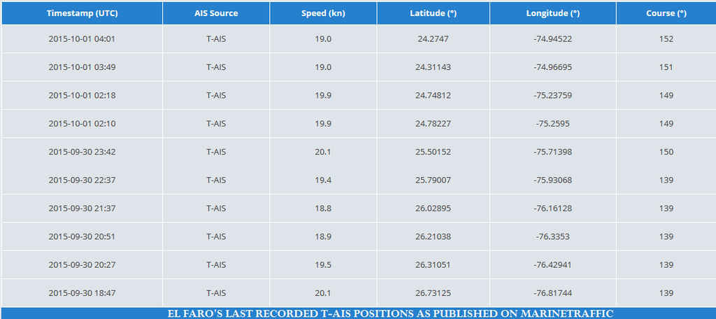
I’ll just post the final T-AIS positions that I see from El Faro, for the record:

[QUOTE=tugsailor;170799]Any confirmation yet on whether the VDR was a float free type? Do VDRs normally have pingers? If so, how long do the pingers transmit? I heard a TV report that the VDR has a pinger that transmits for 30 days. I do not know, but I am skeptical of that claim.[/QUOTE]

I have seen nothing on this issue yet, and I have several browser windows open to official channels waiting to see the answer.

[QUOTE=QuabbinHiker;170814]I have seen nothing on this issue yet, and I have several browser windows open to official channels waiting to see the answer.[/QUOTE]

Look one post above yours. If an NTSB vice chairman says they will use ROVs to get the VDR I guess it ain’t a float free.

[QUOTE=+A465B;170758]Yes, modern ships have access to multiple sources of weather data, including that prepared by accredited weather professionals on a paid basis.
Do not assume the sisterships passed.
No data has been posted indicating the route of the sistership, except the posted recollection of a Jax port worker. (which may prove entirely accurate and insightful - we do not know)
But yes - weather data is available in depth and for my company, it is exceptionally detailed data from multiple sources (not weather channel summaries)[/QUOTE]

It took me awhile to figure out that the 2nd and 3rd lines refer back to my initial post. Although, I don’t exactly understand how the El Faro and El Yunque could have ‘passed’ one another when the JAX port worker claimed, to the contrary, that the sister ship in fact circled around Cuba. Who’s on first here? Or did I lose something in the translation? It would nice if CjRoro would get back online to back up his claim.

The 1st and 4th sentences do, however, confirm one another and (along with a couple of intervening posts) lead me to return to my initial assumption that the El Faro had all the meteorological input they could dream of. So allow me to reiterate and ask again (and I’m not the only one interested now) what would you have done in those first 24 hours following JAX departure with the weather information that I previously had laid out (and valdunuz has since shown on the map)? This is hardly an effort to smear the skipper of the El Faro. How can it be? You simply cannot lay criticism on someone for having deviated from rules and operating procedures unless you know what those rules are to begin with. And I don’t. If my timid attempt to find out what these might be are any indication, it isn’t even sure that there are any. All I seem to be hearing is ‘you can’t compare, every situation is different’ or ‘you’ve got to be in thick of things first to really sense your options’. Wing it. In which case, why bother to even train? MariaW narrowed the question down to the specific. And I’ll rephrase it: what is YOUR policy with respect to the Mariner’s 1-2-3 rule? Days and distances, storm diameters and wind speeds. Rules & instruments vs instinct & experience. Is there collegial consensus or is it just every skipper for himself? Where do you draw the line?

EDIT: Mat said:

first make one version of your preparation plan based solely on the actual conditions reported in the NOAA advisories, rather than based on any forecast or forecast track. So you assume the continued forward movement of the storm will be on its current track (plus or minus 5 degrees). You also assume that the storm will develop progressively (the farther away, the more potential for development), disregarding any forecaster’s predictions that conditions are not favourable for intensification. With this plan composed, you can then start assessing forecasts and track models, and weigh up your options accordingly

This is exactly the sort of thought track I’d had in mind. Bravo.

EDIT 2: Sorry for the spelling slip. I’m writing from France…the mind does strange things at 1:00am. Maybe I too should take a pill and hit the sack.

[QUOTE=Phil O’Connell;170815]Look one post above yours. If an NTSB vice chairman says they will use ROVs to get the VDR I guess it ain’t a float free.[/QUOTE]

:frowning: Somehow I missed that, I have information overload right now I guess. Thanks for pointing it out. Do we know if they are detecting the “Ping” if this is the style in use?
[QUOTE=eidassan;170816]It took me awhile to figure out that the 2nd and 3rd lines refer back to my initial post. Although, I don’t exactly understand how the [B]El Paso[/B] and El Yunque could have ‘passed’ one another when the JAX port worker claimed, to the contrary, that the sister ship in fact circled around Cuba. Who’s on first here? Or did I lose something in the translation? It would nice if CjRoro would get back online to back up his claim.

The 1st and 4th sentences do, however, confirm one another and (along with a couple of intervening posts) lead me to return to my initial assumption that the [B]El Paso[/B] had all the meteorological input they could dream of. But then do you seriously suggest (as you seem to in your post to Mr Steel) that within a matter of hours following departure the communication systems on board the [B]El Paso[/B] could have failed and presumably prevented them from receiving some or all of that precious weather data? You’re certainly being generous with the benefit of doubt, but in that case why wouldn’t you also assume that the same event that took the coms out took out the navs as well? Or the entire electrical system for that matter. Yes of course this is all hypothetical? But it was you who got all up in arms about ‘speculation’. And on balance, I’d say that asserting the spontaneous loss of a satellite feed is far more ‘speculative’ than a captain deciding to get a closer look at Joaquim.

But again, I was never speculating to begin with. I asked, and I’ll ask it again (and I’m not the only one interested now) what would you have done in those first 24 hours following JAX departure with the weather information that I previously had laid out (and valdunuz has since shown on the map)? This is hardly an effort to smear the skipper of the [B]El Paso[/B]. How can it be? You simply cannot lay criticism on someone for having deviated from rules and operating procedures unless you know what those rules are to begin with. And I don’t. If my timid attempt to find out what these might be are any indication, it isn’t even sure that there are any. All I seem to be hearing is ‘you can’t compare, every situation is different’ or ‘you’ve got to be in thick of things first to really sense your options’. Wing it. In which case, why bother to even train? MariaW narrowed the question down to the specific. And I’ll rephrase it: what is YOUR policy with respect to the Mariner’s 1-2-3 rule? Days and distances, storm diameters and wind speeds. Rules & instruments vs instinct & experience. Is there collegial consensus or is it just every skipper for himself? Where do you draw the line?

EDIT: Mat said:

This is exactly the sort of thought track I’d had in mind. Bravo.[/QUOTE]

The name of the ship was El [B][I]FARO[/I][/B]

It cannot be true that USCG has called off the search and not officially mentioned the recovery of the single body found. Or does this mean that they indeed left the victim to its devices out there in the flotsam? This is the sort of question that should have a ready answer. Or is this going to play out as yet another example of American military [I]savoir-faire[/I]?

@ QuabbinHiker

In your research regarding VDRs could you attempt to establish whether these maritime recorders are considered as structurally secure as their airline cousins? There were some major doubts a while back as to whether these apparatus could withstand the pressures of -15000 feet. Aviation black boxes will resist depths down to 20,000 ft. Thanks

[QUOTE=QuabbinHiker;170817]:frowning: Somehow I missed that, I have information overload right now I guess. Thanks for pointing it out. Do we know if they are detecting the “Ping” if this is the style in use?[/QUOTE]

I am quite certain they don’t even have a ship ready to begin looking for the sunken hull yet alone listen for the VDR’s beacon. Mind you too that the VDR is likely still attached to the ship on the deck above the EL FARO’s bridge so find the ship find the VDR capsule. I would expect at least a week before we know who is going to conduct the search for the sunken hull and when that search will commence.

The equipment to conduct this search and VDR recovery is not in the USCG inventory nor do I believe it is held by the Navy. NOAA might have it but certainly UNOLS has everything…sidescan sonars and ROVs. Look for Harbor Branch to do it if they have a vessel available. They are closest to the scene.

Wouldn’t the U.S.Navy already know exactly where it is? SOSUS ?

[QUOTE=eidassan;170820]It cannot be true that USCG has called off the search and not officially mentioned the recovery of the single body found. Or does this mean that they indeed left the victim to its devices out there in the flotsam? This is the sort of question that should have a ready answer. Or is this going to play out as yet another example of American military [I]savoir-faire[/I][/QUOTE]

This was discussed in previous posts. A USCG diver confirmed a body was in the survival suit. They decided not to spend the effort and time to recover the body so they could focus their limited sea and air assets searching for possible survivors. I had given my thoughts on this decision in an earlier post.

It is heart-breaking that the USCG described the deceased as not a “body,” but as “human remains” that were unidentifiable.

That could mean that the body was so severely decomposed or suffered so much trauma that it could not be identified without DNA, dental records, etc.

The USCG also stated it would not be recovering floating debris. However, the NTSB may now want to retrieve what they are able to…

[QUOTE=eidassan;170816]…

But again, I was never speculating to begin with. I asked, and I’ll ask it again (and I’m not the only one interested now) what would you have done in those first 24 hours following JAX departure with the weather information that I previously had laid out (and valdunuz has since shown on the map)? This is hardly an effort to smear the skipper of the El Paso. How can it be? You simply cannot lay criticism on someone for having deviated from rules and operating procedures unless you know what those rules are to begin with. And I don’t. If my timid attempt to find out what these might be are any indication, it isn’t even sure that there are any. All I seem to be hearing is ‘you can’t compare, every situation is different’ or ‘you’ve got to be in thick of things first to really sense your options’. Wing it. In which case, why bother to even train? MariaW narrowed the question down to the specific. And I’ll rephrase it: what is YOUR policy with respect to the Mariner’s 1-2-3 rule? Days and distances, storm diameters and wind speeds. Rules & instruments vs instinct & experience. Is there collegial consensus or is it just every skipper for himself? Where do you draw the line?

…[/QUOTE]

A desire to learn is commendable.

  1. At this stage we rather need to know more
  2. What would I have done? Refer to point 1 above.

You aren’t going to get a meaningful answer until the facts are out, and darned few professionals here are willing to answer because:

A. They know that we don’t have information needed to make (or opine on) such a decision, and
B. We know in our hearts that reality is, “There, but for the grace of God, go I…”

So I give up on 'splainin

[QUOTE=Kp72;170187]Hey KP Mom,

I see no one replied to your question so I registered just so I could reassure you as a former ship master and harbor pilot that your son has entered a noble profession. An occurrence such as this tragedy is rare, very rare, so rare that after forty-seven years in the maritime industry I cannot recall a similar event. Rest assured that your son will be well cared for as he embarks on his career first as a “cadet” née Midahipman and then as an officer. This is truly a sad day for all Mariners and one that is a kick in the stomach for many of us who have made a career at sea. Don’t worry: your son will be fine and well cared for.

'72[/QUOTE]

Thank you very much for your kind words. I’m sorry I didn’t see your post until today. I continue to be amazed at the strength and reach of the KP Family and its members, and in the face of this tragedy, the entire maritime community. It’s a world about which I knew next to nothing when my boy set foot on campus last year. I certainly have learned! Of course KP is mourning the loss in particular of El Faro’s Chief Mate Steve Shultz, Class of '84 and a proud member of Band Company like my son.

I spoke to my son (a Deckie) and he does remain very excited to commence his first sailing Oct. 30. He is well aware of the rarity of this event and I’m sure it has been discussed in class

I’ll take this opportunity to say again that my heart goes out to all the El Faro crew families, their friends and everyone who sailed with them or knew of them. Twilight today has extra meaning…

[QUOTE=Mat;170800]Hi, I’m Mat! The one who posted the graphics?!
QuabbinHiker is Mike. Mat is Mat. Its really not that complicated!
I see Mike posted some good graphics from Jeff Masters, who is very good at this stuff, and very experienced with Tropical stuff.
I will see if I can work on finding the forecasts and match them against actual tracks and ship positions as well (no promises)
My theory is that, in general, looking at the models and track forecasts, and giving them more weight than they rightfully deserve, can skew the passage planning process. I wrote an article published in the June issue of Caribbean Compass which looked at Hurricane preparations for yachts staying in the islands during the storm season, in which I suggested that when faced with an approaching storm you should "[I]first make one version of your preparation plan based solely on the actual conditions reported in the NOAA advisories, rather than based on any forecast or forecast track. So you assume the continued forward movement of the storm will be on its current track (plus or minus 5 degrees). You also assume that the storm will develop progressively (the farther away, the more potential for development), disregarding any forecaster’s predictions that conditions are not favourable for intensification. With this plan composed, you can then start assessing forecasts and track models, and weigh up your options accordingly.[/I]"
I believe that computer model tracks showing movement of a system in completely the opposite way to which it is currently moving do not help anyone make an informed decision as to where it is safe to proceed. In such a case it is only prudent to consider the continued forward movement of the system, until such time that a significant change in direction occurs.
Article link: http://www.caribbeancompass.com/hurricanes_windwards_2015.html
I’ll just post the final T-AIS positions that I see from El Faro, for the record:
[/QUOTE]

This is very good work Mat. I am working on custom maps myself, using data from various sources. Would you like to collaborate? I am a “Map guy” myself.

A story I found that maybe explains something mariners feel about disaster …

[I]The Mistral hits like a bomb in October, a northerly wind reaching across the stretch between Marseille and Corsica. It howls as it passes, then the sky turns the clearest of blues, and a cold descends. Safe behind the wall at Antibes, you feel the summer draining away as fallen leaves twist and fly across the ancient stones. On the sea, it rides there, in your mind. Mistral.

A quick job, four bolts, a gasket, some wires. Ten minutes, maybe. We gathered the parts and eyeballed the horizon. It was gusty day. Silvery patches of light skidded across the iron colored seas, whitecaps everywhere. The ship moved easily – she was a big one, with the feel of safety itself. Long, easy rolls in that autumn sea.

It was time. We descended to the deck, the two of us, hands busy with the tools. We came to it, and worked quickly. Few words were spoken – Move, go. Move, go. The deck edges dipped in an easy rhythm, maybe six inches of cold water running to us, then away, the deck half awash, half flowing. Almost done now.

We both felt it. I suppose. The light shifted in that way a sailor can sense. I looked toward him, then beyond. A meter to the rail? A little more? Oh God! I curled up, locking my arms across the bitts. Instinct really, blind luck to be at that one place above all others … nothing more. I’m sure. Now.

Maybe a heartbeat passed as we went under. Two meters perhaps, but did it really matter? The light returned as the water drained away. Then slowly, I lifted my head, eyes locked to the empty deck.

Twenty autumns have passed so far. Each time the air grows cold, and the light is just so, I go to the shore and look out, eyes probing that silvered horizon. On the Great Beach below the waves keep on with their crashing, here on this island place. Their rumble still drifts up the dune face, reaching me as I huddle in the grasses above, around me, the sand gently releasing the last of summers’ warmth.

His face is faded now.

Was it like being carried by a thousand hands, the way it felt as a child tossed aside by the waves below, at this very shore?

Was it that same surprising, laughing, bubbling, pushing high and low all at once, everywhere, everything, feet lifting, legs and body massaged and carried by the churning water?

What was it like to look up …. and see only the sky?[/I]

So now you know why speculating hurts.

[QUOTE=eidassan;170820]It cannot be true that USCG has called off the search and not officially mentioned the recovery of the single body found. Or does this mean that they indeed left the victim to its devices out there in the flotsam? This is the sort of question that should have a ready answer. Or is this going to play out as yet another example of American military [I]savoir-faire[/I]?

@ QuabbinHiker

In your research regarding VDRs could you attempt to establish whether these maritime recorders are considered as structurally secure as their airline cousins? There were some major doubts a while back as to whether these apparatus could withstand the pressures of -15000 feet. Aviation black boxes will resist depths down to 20,000 ft. Thanks[/QUOTE]

Of course, I will do so. But I suspect members of this forum could provide the answer as well from memory. I will attempt to find the exact specs of the VDR that was on the El Faro, who made it, etc. I am very good at searching the internet as it’s part of my day job.

      • Updated - - -

[QUOTE=Reginald Strainworth III;170825]This was discussed in previous posts. A USCG diver confirmed a body was in the survival suit. They decided not to spend the effort and time to recover the body so they could focus their limited sea and air assets searching for possible survivors. I had given my thoughts on this decision in an earlier post.

It is heart-breaking that the USCG described the deceased as not a “body,” but as “human remains” that were unidentifiable.

That could mean that the body was so severely decomposed or suffered so much trauma that it could not be identified without DNA, dental records, etc.

The USCG also stated it would not be recovering floating debris. However, the NTSB may now want to retrieve what they are able to…[/QUOTE]

This posting has disturbed me to the core. I have no words to explain how I am feeling about this, but I will try. A profound mixture of sadness and rage. That crewman DESERVED to come home no matter the condition. To leave him or her in the sea is vile.

I agree that they should have recovered the body. It would not have taken long. It may have provided helpful information. it would not be a false lead for the next vessel searching for survivors. The family needs to know, even if the body was in a condition not fit for viewing.

Now they should go back and try again to recover the body.

Was not planning on posting again as I am more of a reader of posts than a generator of them, but after hearing that the NTSB plans to go after the VDR, I was not only surprised but pleased. Frankly, I did not think they would take this step given the depth the vessel likely settled at and the complexity of such an operation.

I truly hope this operation does come to pass and that it yields not only the VDR but also some measure of closure, albeit small, for the families of the crew.

Locating the VDR and extracting its data will hopefully be viewed as an opportunity to explain how this tragedy occurred and to learn from it rather than assessing blame. Given the circumstances, assessing blame at this point is a fruitless endeavor. The families deserve some closure and the industry can benefit from the post incident analysis, but finger pointing for the purposes of blame assessment will only be hollow.

I remain hopeful as well that despite the horrible nature of this incident, it will bring about a serious discussion regarding the state of the US Merchant Marine. While it is encouraging to see TOTE, Crowley, Pasha and others building new US flag tonnage lately, in my opinion, we are still far from where the fleet needs to be relative to the actual needs of the country.

[QUOTE=+A465B;170826]A desire to learn is commendable.

  1. At this stage we rather need to know more
  2. What would I have done? Refer to point 1 above.

You aren’t going to get a meaningful answer until the facts are out, and darned few professionals here are willing to answer because:

A. They know that we don’t have information needed to make (or opine on) such a decision, and
B. We know in our hearts that reality is, “There, but for the grace of God, go I…”

So I give up on 'splainin[/QUOTE]

Fine then, and so I guess I’ll give up on askin’. Even if I still find it hard to fathom why the details of the singular case of Capt Anderson should be the prequisite in order to write the Mariner’s Manual of the communitiy. But I won’t fight it. While I agree “few professional are willing to answer” I sense there are other reasons for this than you would have us believe.

At any rate I’d like to offer up again my apologies for having misread a quote you made in my earlier post, that I’ve since edited out. And as for that other boner I committed (what did I call that ship…El Taco?) The truth is that not only do I do most of my posting when most civilized people should be in bed I have this terrible habit of sitting down with a large bowl of Doritos tortilla chips (best you’ll find this side of the Atlantic) and a jar of…El Paso salsa. I think they call it the lobe transfer syndrome. Something to do with the hunger side of the brain simply hijacking your entire conscious soul. Oh, well good night all.

[QUOTE=c.captain;170821]I am quite certain they don’t even have a ship ready to begin looking for the sunken hull yet alone listen for the VDR’s beacon. Mind you too that the VDR is likely still attached to the ship on the deck above the EL FARO’s bridge so find the ship find the VDR capsule. I would expect at least a week before we know who is going to conduct the search for the sunken hull and when that search will commence.

The equipment to conduct this search and VDR recovery is not in the USCG inventory nor do I believe it is held by the Navy. NOAA might have it but certainly UNOLS has everything…sidescan sonars and ROVs. Look for Harbor Branch to do it if they have a vessel available. They are closest to the scene.[/QUOTE]

Harbor Branch has been out of the Research Vessel business for 5+ years. Sold them all off, rescinded their membership in UNOLS, and no longer operates their submersibles or ROV’s. A sad thing. In any case, they never possessed the equipment needed to work in the depths that El Faro is likely sunk. Best bet would be an ROV equipped construction vessel out of the GOM. There is at least one US Flag vessel that I know of that could undertake the effort. Lets hope the NTSB will get a vessel out there quickly, and the VDR can survive that kind of pressure - more than 7500 psi. May take a bit of time to locate the wreck. Dragging a sidescan SONAR around for a while, or an AUV equipped with a sidescan. If the VDR is equipped with a pinger, and it survived the sinking, that could speed things up greatly. My prayers for the crew and their loved ones.

[QUOTE=eidassan;170840]Fine then, and so I guess I’ll give up on askin’. … While I agree “few professional are willing to answer” I sense there are other reasons for this than you would have us believe.

At any rate I’d like to offer up again my apologies for having misread a quote you made in my earlier post, that I’ve since edited out. …[/QUOTE]

Nope. That’s the reason.

We just do not know why things happened at this point in time, and just blurting out an uninformed answer / opinion in this deadly incident does dis-service and is disrespectful to those actually involved, especially the innocents who will question “why”, forever.

The US merchant marine is a small community of a few thousand, subdivided further by coast, trades, ship types, unions and schools. The people come from a few geographic areas, in general, even specific islands. Not all, but this is how it stacks up. So people know one another, whether they hate or love each other. Two kids in my family are at sea right now. Tonight. So we see and feel when it goes wrong. Maybe like Fragat, I’ve spent a storm worth of nights huddled in the engine room, survival suit beside me, deathly afraid because if we lost the plant it was certain we would go broadside and capsize. (Not saying that is what happened here).

So welcome to our thoughts … Change into your clean coveralls before you come into the messroom and set a spell.

Nothing more to it.

      • Updated - - -