
Graphics showing possible scenario for El Faro’s intention heading into Bahama Islands.

I’m losing track of the posts, going to see if I can move it here.
](https://flic.kr/p/zAiTNU)image by kennebeccaptain, on Flickr[/IMG]
It does appear that they were headed for Crooked Island Passage, I don’t where the information that it was their intention. However upon reaching Rum Cay, where a turn to about 180 (south) would be expected they seemed to have turned SE. There are no time stamps on either the AIS or system so it’s diffiuclt to get an idea of the siutaton. One possibility is that turn was forced due to problems, to ease the motion, the list or to put the hatch problem in more of a lee. May have been a forced maneuver for repairs? I wonder if they were at full speed or hove to?
Another little piece of the puzzle.
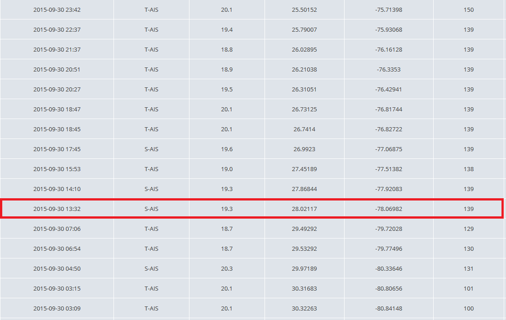
AIS Positions from El Faro’s last voyage.
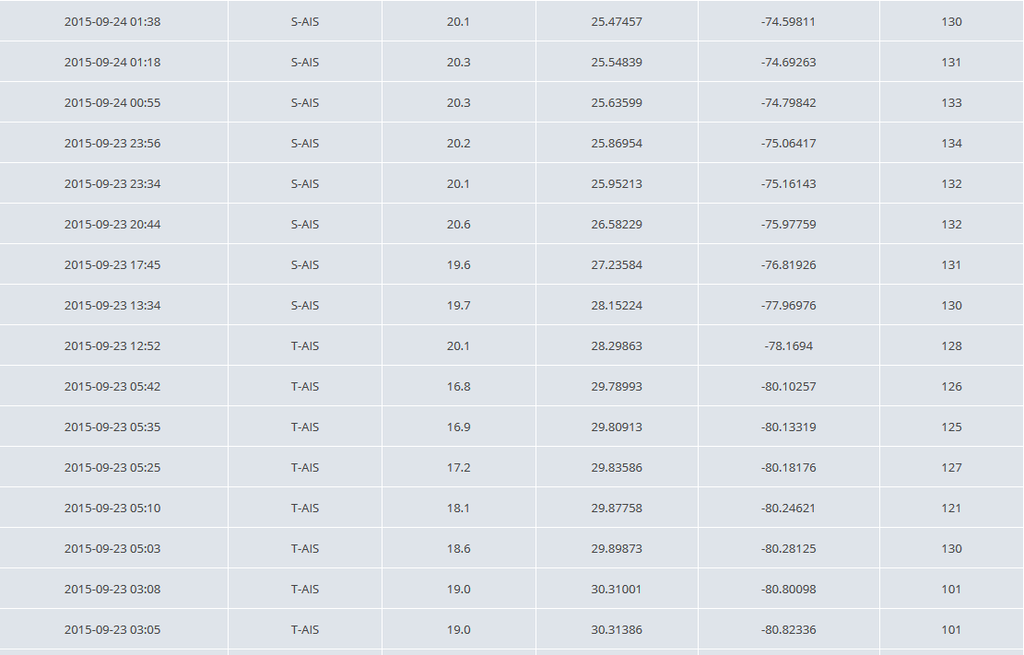
AIS Positions for the previous voyage.
This is just to give an overview, I’d be careful drawing any conclusions from as there are some assumptions made. However I think it shows the lay of the land. Take it for what it’s worth.
The waypoint "EF 01/0400 is the last position we have of the El Faro. 24.27N 74.9W The rest of the track are assumptions.
“0300 UTC J” and “0900 UTC J” are the 0300 and 0900 NHC positions for Joaquin.
](image | kennebeccaptain | Flickr)image by kennebeccaptain, on Flickr[/IMG]
For scale the 60 miles is line running 271 from the green dot to the red dot.
I assumed a track thru Crooked Island Passage. For the first leg “EF 0400” to “EF 0600” I used 20 kts which gives turn at Rum Cay at 0600. Perhaps a bit later.
For the next leg “EF 0600” ti “EF 0930” I used 15 kts, not sure how good that estimate is. The puts the El Faro at Crooked Island at about 0930 UTC. Depends on the weather and the ship.
PRESENT MOVEMENT TOWARD THE WEST-SOUTHWEST OR 240 DEGREES AT 4 KT
ESTIMATED MINIMUM CENTRAL PRESSURE 948 MB
MAX SUSTAINED WINDS 105 KT WITH GUSTS TO 130 KT.
64 KT… 25NE 30SE 20SW 20NW.
50 KT… 40NE 60SE 30SW 40NW.
34 KT…100NE 120SE 100SW 80NW.
12 FT SEAS…220NE 180SE 100SW 180NW.
WINDS AND SEAS VARY GREATLY IN EACH QUADRANT. RADII IN NAUTICAL
MILES ARE THE LARGEST RADII EXPECTED ANYWHERE IN THAT QUADRANT.
REPEAT…CENTER LOCATED NEAR 23.4N 73.7W AT 01/0900Z
AT 01/0600Z CENTER WAS LOCATED NEAR 23.5N 73.5W
The limit of the 50 kt wind field is more or less then the CPA of 60 miles depending on speed, position etc.
I wouldn’t put too much weight on this, the NHC gives the position as accurate to within 25 miles, that alone could be significant.
- EDIT The master called the company DPA at 01/0700 hrs, that’s 1100 hrs UTC. Don’t know how that fits with the other times.
I believe that cleared the paasage between Rum Cay and San Salvadore or the prevailing winds should have blown them ashore on the latter. There is a Reuters story at the gCaptain mainpage that mentions a last reported position at 0356EDT which does not actually place the ship geographically however I believe this is about the time of the propulsion casualty due to the speed drop reported because with wind and seas on the stern there is no good reason at all for the master to slow down then with the storm center less than 50miles away and headed for them. The reported location where EL FARO was lost fits with a ship drifting for several hours to the north of the Crooked Islands and into the eye of the vortex.
At 2:09 a.m. ET, Oct. 1, El Faro was only 50 miles from the eye of Joaquin. At that point the ship was still moving at nearly 17 knots, according to the ship tracking data.
Facing fierce winds and high seas, the ship had made little progress by 3:56 a.m. ET. In its last logged location, the ship was less than 50 miles from the eye and had slowed down to 10.7 knots.
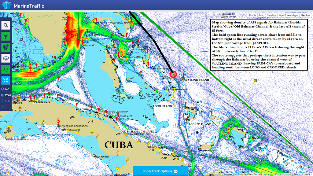
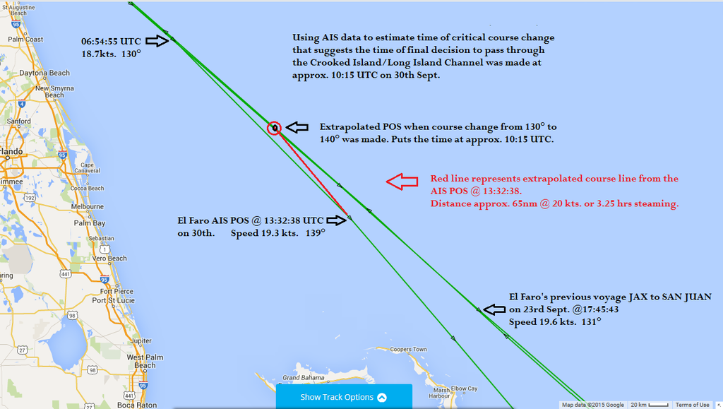
Speculation as to their intended course, based on study of AIS density map.