MV Nyerere Capsize

Disaster tourism is a curious human need that seems to be engraved in man’s DNA. It is a world wide phenomenon to be found in every civilization.

Tour operator at work. Paying for the privilege, passengers on the MV Nyehunge look across at the capsized MV Nyerere as it lies upturned near Ukara Island, Tanzania.

IMG_3203
Non paying tourists at the beach.

IMG_3199

Even 'disaster selfies’ are priced possessions.

The only thing that’s really changed is that the technology to capture the moment has improved, while society’s standards have, sadly, declined.

It probably makes us also visit in droves historic places like Pompei in Italy, Gettysburg, Pennsylvania and Pearl Harbor.

IMG_3204

MV Ukara with a capacity of carrying 70 passengers and no cargo allowed is undergoing testing after major maintenance before being authorized to travel between Ukara and Bugurola Islets.

MV Sabasaba, which has a capacity of carrying 300 passengers, is also undergoing major maintenance before starting to travel between the two sides. After having brought the wrecked MV Nyerere to the coast a car (!) and some other properties including building material will be salvaged.

They do some ‘major maintenance’ on the replacement ferries probably to prevent more mishap from occurring.

A former Washington State ferry capsized there some years ago, killing hundreds. Google M/V Skagit. The tendency is to overload. Period.

2 Likes

IMG_3223

The m.v. SKAGIT and m.v. Kalamata were former Washington State Ferries. There were complaints then about the 25 knots (2840 Hp) ferries regarding shore erosion caused by their large wakes and about their propensity to roll in the waves. The original design of the boats was based on vessels that serviced off-shore oil rigs in the Gulf Of Mexico. An extra deck of superstructure was added to accommodate additional passengers and probably like the Sewol more ballast to compensate for this.

They were small slender - the L/B ratio is about 4.5 - ships built for speed and not really fit for duty in these waters with high winds and seas. They offer a boxlike view, not very elegant, but more important is the fact that there will be a large wind pressure, sail area present apart from the tendency to roll easily in the waves which is an indication of a low GM.

The small ship ran into high winds and heavy seas while sailing from Dar es Salaam to Zanzibar Island, a distance of about 55 sea miles, which caused it to list heavily and ultimately capsize. Survivors reported that the engines failed as the vessel rolled, then the vessel wobbled three times and capsized and turned completely over, its quadruple screws pointing towards the sky. A kind of El Faro scenario with what looks like a parametric roll thrown in for good measure.

IMG_3222

It does not even look 34 meters long, such a tiny hull. Shortly after this picture was taken the ferry sank.

Hanzil Manoni, one of the survivors, told Xinhua on Friday that the MV Skagit left Dar es Salam port midday on Wednesday without any problem, but after thirty minutes the vessel “started to lose control.” He said after two hours of their departure, as the speed of the boat increased against strong wind, high waves pounded the vessel causing instability, but the Captain informed them there was no problem and the boat would proceed to Zanzibar. Unfortunately shortly after the Captain’s statement, the vessel wobbled three times and capsized leaving us to struggle for our lives,” He recounted the defining moment of life and death.

The owner and captain of the boat were missing after the incident…

The number of passengers is often mentioned as being 290 while 250 were allowed. One source even speaks of carrying 447 passengers. The death toll and number of survivors is unsure because many sources present different figures, one claimed 81 lives and 212 missing. Another source claims an estimated death toll of 293.

It was said that the Puget Sound ferry community had not a good feeling about the sale of the ships to Tanzania which require a strict safety code and passenger count. It was expected that such rigid adherence and concern for safety was not an established practice in Tanzania. How true…

1 Like

This was posted on February 29, 2012 by Aviation, tourism, travel and conservation news - DAILY - Eastern Africa and the Indian Ocean islands.

ZANZIBAR MARINE AUTHORITY STOPS FAULTY SHIP FROM SAILING FOR PEMBA

It appears that the lessons learned from the disaster of the sinking of the MV Spice Islander I last year were learned well when the Zanzibar Marine Authority prevented a vessel, set to sail to Pemba, from leaving port, after the ships safety was called in question over its mechanical condition.

MV Skagit was compelled to remain in port following the order being served on them leaving all passengers stranded but safe on shore, though unable to travel without first having their fares refunded, something the company has up to now refused to do.

A source from Dar es Salaam mentioned overnight that the last safety inspection of the ship in late 2011 revealed apparently defects which were cited and ordered for repairs, but with that not done the Marine Authority opted to rather ground the vessel than risk another tragedy on the open sea.

Owners representatives were predictably negative about the action and denied that they were in any default but a statement from the Zanzibar Marine Authority tells a different story now whom to believe or is it simply safety must come first.

And here the necessity of overloading is explained.

Ship owners are slow to make repairs when ordered and unlike last year, before Spice Islands sunk, the authority is now under public scrutiny to act decisively. It is the operators to blame for not fixing their boats, but some have claimed that they no longer make enough money when operating within their load limits. In the past they overloaded and got away with it and made a lot of profits but that is now almost impossible to get away with. Even back packer tourists are now frequently asking who safe a particular ship is they want to use and then rather wait for another when they are not satisfied.

Notice the ramp at the bow which is lowered on the beach.

On 10 September 2011, the mv Spice Islander I sank resulting in the deaths of 1,573 people; many of whom were never recovered. The ship’s official capacity was 45 crew and 645 passengers, but it was reported to be heavily overloaded. Around four hours after departure the ship sank between Zanzibar and Pemba. The ship is thought to have capsized after losing engine power.

IMG_3227

The ship had been bringing people back from holiday after Ramadan, and had stopped earlier in Tanzania’s commercial capital, Dar es Salaam. There some passengers had refused to board the ferry because it was evidently overloaded.

IMG_3226

In an investigative report published on 19 January 2012, of the 2,470 passengers 203 were confirmed dead, and 1,370 missing.

Eight months later, the MV Skagit, another ferry on the same route, sank also with large loss of life.

According to a ruling in 1914 of the Zanzibar High Court the Tanzania ferry owners go free, denying justice for victims although it was beyond dispute that the ferry was overloaded by at least four times the number of passengers it was licensed to carry. One could say that the ruling has all the makings of that of a Banana Republic, sad.

Some more disasters in that area can be found here.

1 Like

As mv Apostolos P (1988–2007) flying the Greek flag and still looking good. It is difficult to imagine how it will look like with 2470 persons on board!

I have been tinkering around a bit with the hydrostatics and other statistics of the wrecked mv Spice Islander I. That exercise suits no other purpose except to satisfy my personal curiosity of what happens to a ship’s vital parameters when it is obviously so grossly overloaded with 2470 passengers and crew instead of the 690 that were allowed according the COI.

It is beyond my understanding that a captain, if you may call him that, thinks he can get away with such an overload, although I suspect that this was probably not the first time that such overloads occurred. A ship needs only a nudge of a wave or increasing wind force to tip over, it is a balancing act on a knife’s edge.

Here are some data which are publicly available.

History

  • mv Marianna (1967–1988)
  • mv Apostolos P (1988–2007)
  • m Spice Islander I (2007–2011)

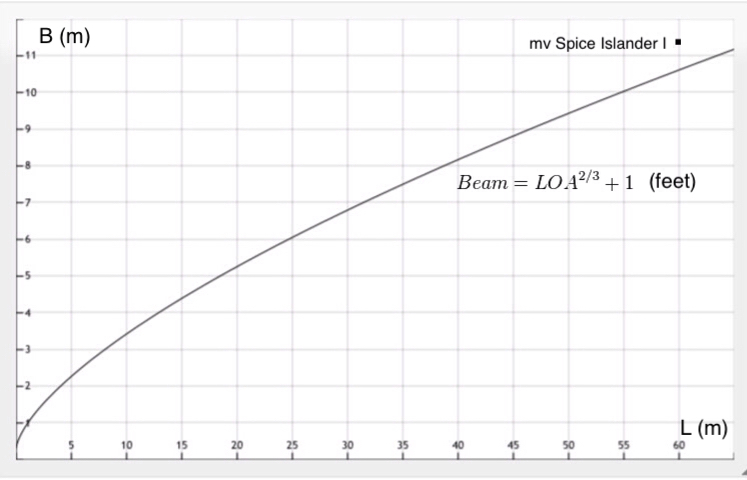
Length 60 m (196.85 ft)
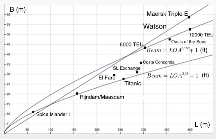
Beam 11.4 m (37.4 ft)
GRT 836
NRT 663
DWT 225
Speed 11,5 knots
Propulsion: Two Poyaud 12VUD25 diesel engines of 1,560 horsepower (1,160 kW).
Propellers 2
Capacity according to COI:
Crew 45 Passengers 645
Actual total number of passengers and crew on board 2470
Overload 358%

First of all I will try to calculate the displacement. For that we have to find the block coefficient Cb.

To accomplish this I used Ventura’s Estimation Methods and calculated Cb with five different formulas. I dropped the lowest and highest value and averaged the remaining three, which were closely grouped. The resulting figure was Cb = 0.61.

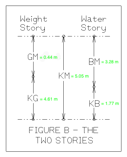
Next we need to know the draft of the ship. With a ruler we can measure on the above picture the freeboard. First I measured the distance from the deck to the loadline marking and divide that by the length of the ship, again with the ruler. Multiply the quotient with 60 m and the outcome of the freeboard is about 3.12 m, not very accurate but sufficient for this purpose. With known ratios of more or less the same type of ships, such as B/D and T/D, we can calculate estimates of D and T. For the ratio B/D for instance the value 1.63 is taken and for T/D 0.49, then D = 6.17 m and T = 3.05 m. The freeboard D - T = 3.12 m.

The displacement or Δ = L x B x D x Cb = 60 * 11.4 * 3.05 * 0.61 = 1273 ton.

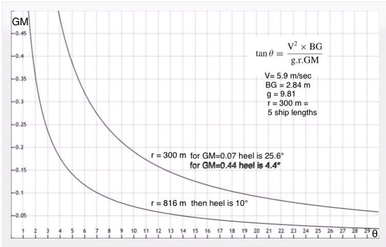
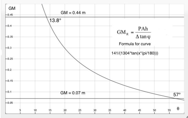
Next we calculate the GM with the USCG Weather Criterion formula: GM = PAH/ W * tan θ, where θ = 14°.

P = 0.055+(L/1309)^2 = 0.055 + (60/1309)^2 = 0.057101. PAH being Pressure x Area x Height - W is displacement and θ is the angle of heel (1/2 Deck edge immersion or 14 degrees). - The pressure being approx the equivalent of about 55 kts.

It is somewhat special that the angle with the point of deck immersion is cotan of freeboard divided by 1/2 B = 3.12/5.7 = 0.547368, then θ = 28.69°, the half value of that angle is a just a little bit over the other value of 14°.

From the picture I found:

A ≈ 450 m^2
H ≈ 5.49 m
PAH ≈ 141

GM = PAH/ W * tan θ = 141/1273 * tan θ ≈ 0.44 m.

For small passengers ships with a length of 50 - 120 m the ratio DWT/Δ (%) = 15 - 25. mv Spice Island I has a ratio of 17, which checks out for this type of ship.

The DWT can be divided in CDW = Cargo DW and SDW Ship’s DW.

Rule of thumb: DWT= 1.05 x CDW 225 = 1.05 x CDW -----> CDW = 225/1.05 = 214 ton. Ship’s DWT of SDW= 11 ton.

In modern times we work with GT instead of GRT. Just for the fun I will calculate the GT with the help of a simplified set of gross tonnage formulas set forth by the U.S. Coast Guard Marine Safety Center, which are based on three measurements: Length (L), breadth (D), and depth (D), thus not d or T as for draft but D for Depth!

For freighters the simplified formula is: Gross Tonnage = (.67 x L x B x D) divided by 100, with LBD in feet.

I further simplified the formulas for the GT for LBD both in feet and meters:

GT = 0.0067*(L * B * D) ≈ 493 - LBD in feet.

GT = 0.236427*(L * B * D) ≈ 493 - LBD in meters!

To be continued…

1 Like

With help of the estimation methods more hydrostatics were calculated like this one for KB.

BM was calculated with this formula which I know from experience is pretty accurate.
IMG_2694

The result of all the exercises is shown below.

Passengers on these ferries carry a lot of luggage, food bought on the market and other things. I calculated with an average weight of a passenger of 75 kg and 50 kg of luggage, which brings the total to 125 kg. The number of passengers and crew on the COI was 690 while the actual number on board was a staggering 2470. The overweight is then 2470 - 690 = 1780 * 0.125 ton = 222.5 ton.

Furthermore it seems that there was also unauthorized cargo brought on board, which is hardly surprising. A rough guess could be 10% of the CDW = 0.1 * 214 ton = 21.4 ton. Final total overweight is 222.5 + 21.4 ton = 243.9 ton. With a TPC of 4.17 ton/cm this amounts to 243.9/4.17 = 58.5 cm deeper into the water!

The KG is then calculated.

Δ = L * B * D * Cb * ρ = 60 * 11.4 * 3.05 * 0.61 * 1.025 = 1304 ton. Where ρ = density of seawater = 1.025 kg/m3

Δ = 1304 + 243.8 = 1547.9

KG for 1304 is 4.61 Moment about keel is 1344 * 4.62 = 6024.48

KG for 243.9 is 6.87 Moment about keel is 243.9 * 6.87 = 1675.59

Total KG is 7700.07

Final KG = 7700.7/1547.9 = 4.98 m.

GM = KM - KG = 5.05 - 4.98 m = 0.07 m

For calculating some GZ values we can use George Atwood’s formula which he published in 1798 in “A Disquisition on the Stability of Ships”. He described a formula with which the stability of a ship at larger heeling angles could be calculated. Before that time only the static stability for small heeling angles was known. At larger heeling angles it was uncharted territory and many ships sunk like HMS Captain due to a low freeboard and design errors. As a result 500 lives were lost.

Atwood’s formula: GZ = (GM + 0.5 * BM * tan θ^2)) * sin θ

For instance for an angle of 14° GZ = (0.44 + 0.5 * 3.28 * 0.249328) * 0.241922 = 0.19 For the overloaded situation GZ = 0.003 !!

Of course this is a purely theoretical exercise because we know far too little to make an exact calculation. The only intention is to show what more or less can happen if the rules of loading a ship and good seamanship are disrespected as was the case here. Obviously the so called captain had no clue about these things otherwise he would not have risked his own live and that of his passengers. No high tech is involved, only one look at the load line would have been sufficient. Come to think of it, the load line would not have been visible at all…

1 Like

Unless they had one of those new-fangled floating load lines.

Floating load line, innovative idea! Reminds me of my James Bond style rotating number plates. Just push a button and voila a new number appears after being flashed by a speed trap camera…

1 Like

You can find Atwood’s “A disquisition on the stability of ships” that was written in 1798 here. The document downloads a bit slow. You will find the figures mentioned in the book at the end in separate fold-out pages. On Amazon a hardcover is avaible for $ 236.-

It is surprising that it is so readable, as good as todays English.When I read a Dutch text from that period I have some trouble reading it because the language has changed so much.

1 Like

F

To conclude with a little afterthought which illustrates the consequences of the rudder on the ship’s heeling behavior, the USCG Weather Criterion and the rolling time period.

The turning circle manouevre starts from straight motion at the test speed, the rudder is turned to 35° or the maximum rudder angle permissible and kept at this angle, until the ship has performed a turning circle of at least 540°. The trial is performed for both starboard and port side. A five ship length radius is the usual distance for such tests. For starboard the ship will first heel a little to port before the centrifugal force kicks in heeling the ship to starboard and the other way around with a port order.

Under these conditions the ferry will heel 25,6°, which is what could be expected. I even expected a larger heel.
Doodle_2018-10-23T10_25_01Z
The USCG Weather Criterion formula.

With the GM = 0.44 m of a normally loaded ship this value is in the range of 0.3 - 0.5 m which is good. The ship then heels 13.8° and that is within the legal limits. It is a different story if the GM = 0.07 m, the heeling angle is then a dramatic 57°.

The rolling time period for GM = 0.44 m is 13.7 sec and for GM = 0.07 m 34.5 sec from which there probably is no recovery possible. An acceptable rolling period is if 3/4 * B < T < 4/3 * B, which is here 8.6 < T < 15.2 seconds. With the GM = 0,44 m the rolling period is well within the limits.

1 Like

In the past pilots bringing a ship into port loaded to its timber load line kept their coffee in the mug by being very economical with their helm orders.

1 Like

I remember the ships loaded with timber from the Baltic Sea, almost never straight always with a varying degree of heel, came limping into the port of Rotterdam.

They were virtually unsinkable and could not really capsize. When capsized most of the time they lost the timber deck load and then the ship veered right back…

Sometime in the mid-1980s a small Dutch ship loaded with sawn timber from the White Sea got a heavy list while sailing down the Norwegian coast. (Not as bad as the one above)
When they sent MAYDAY message the SAR at Sola sent a Helicopter to pick the crew off.

The salvage tug Max Mamut from Aalesund went out and manage to put a couple of guys on board. They got the engine started and proceeded into smoother waters, where the Salvagemaster put a towline on and towed her to safe port in Aalesund. (He had a LOF and needed to prove that they had done something for the salvage fee)

I was in Aalesund at the time and was appointed by the P&I Club to keep a watching eye on the righting process. The deck cargo was discharged, (gently to avoid any sudden changes in TCG) then reloaded and secured, where upon the ship could continue her voyage.
With full fuel tanks the loll was abt. 2-3 degr. which is normal for a ship with timber cargo.
She got to Antwerp w/o further problems.

2 Likes

The formula in the graph was used by naval architects to calculate the beam from the LOA. For the Spice Islander I it is a little bit off, but this is a ferry with a forward ramp which probably requires a bit more beam. Calculated with the formula the beam should have been 10.62 m instead of 11.40 m.

When ships got longer and new type of ships were developed, like container ships and RoRo’s, the formula doesnot work anymore. I reworked it a little so that it now better fits the new generation of ships. This is illustrated by the graph below.

The straight line is Watson’s. It is too simple and there never will be a linear relationship between L and B. However, in the end it fits the Maersk Triple E class ships perfectly!

This is Watson’s graph from which I took the “most merchant ships” line.