I don’t see how the ship could have grounded there without being both off-track and off-course.

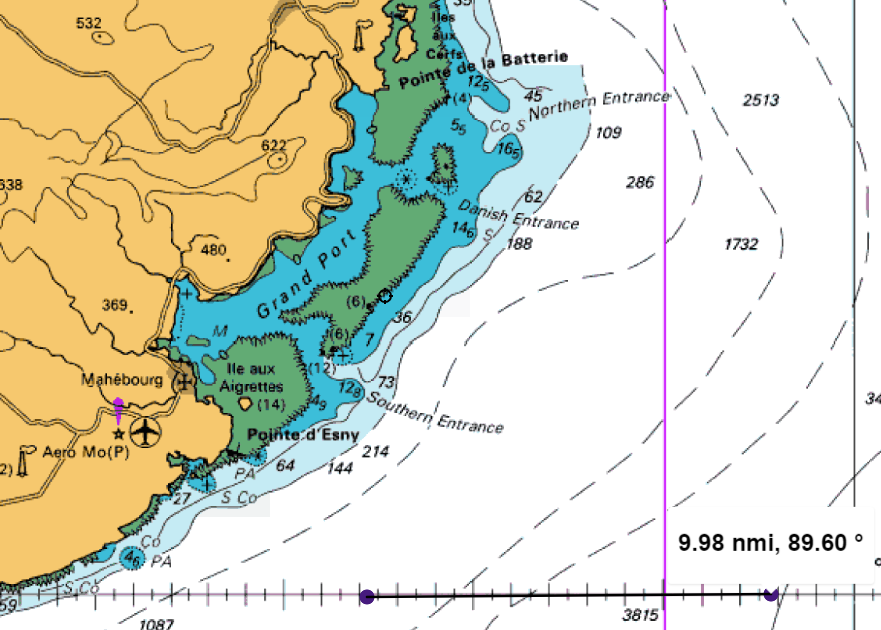
Did the ship ground somewhere east of that outcrop around that charted rock just east of the wreck symbol?
Below the word “Deux”
I don’t see how the ship could have grounded there without being both off-track and off-course.
Did the ship ground somewhere east of that outcrop around that charted rock just east of the wreck symbol?
Below the word “Deux”
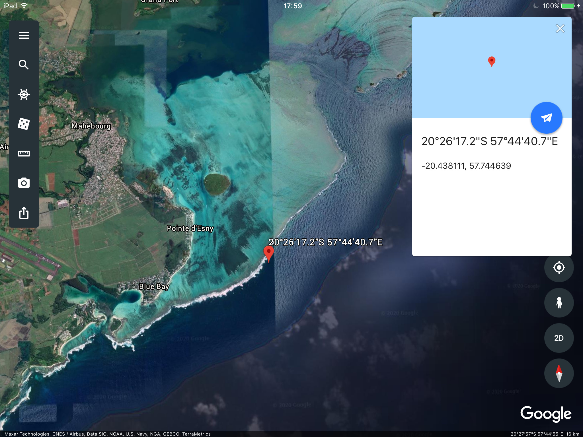
Adding to the number of clues they were headed for trouble, the lights from the town of Mahébourg would have been difficult to ignore.
Seems like they would have had to pass over that 12.8 meter spot at the Southern Entrance.
Most incidents like this have more than one cause. That might be the case here. ECDIS track wrong, radar on the wrong scale and gain turned down too low or similar errors.
Havent had a chuckle recently. Made my day Lee Shore. Chili dogs to follow on my grill,along with the most excellent Silver Queen.
Is that some kind of exotic beer? Please tell me it’s not some bejeweled female impersonator coming over for chillidogs.
Until recently, China’s biggest rival for regional influence was Japan. Following the events of this summer, their biggest rival is India.
China has continually funded movies that promote anti Japanese sentiment. In particular to regional countries such as Korea. An event as devastating as this oil spill may polarize island nations in the Indian and Pacific oceans against anything Japanese. By shaming Japan through this event or reinvigorating hatred left over from WW2, they can wipe out the clout of Japan.
China also cares very little about pristine habitats.
As far as what could have been done to avoid it, the watch officer could have taken radar range and bearing as soon as the island was visible on radar. He could have used parallel indexing to keep track of how close he was to the island. Mariners are not of the state of mind to operate in GPS denied environment. The first chapters of Bowditch are dedicated to such a situation. The Navy’s report of what to do in GPS denied environment gives little to the mariner other than mentioning celestial navigation.
My second chuckle of the day. Silver Queen on the grill is a taste many in this country will not experience.
Which means they aren’t available for making gaskets, either. Had to explain to a young 3rd mate what ‘chart paper’ even means before he could tell me that we didn’t have any. No one considers the real victims of this so-called progress.
Not to mention the Aeronautical beacon right in front of them. That’s just bonkers. Clear nobody was standing much of a watch.
China has been an adversary for many years.They only wish they had something to do with this debacle, but maybe not. So effing stupid would not not claim “And I helped”. Shake and Bake.
Don’t know if it has anything to do with this grounding but Skuld, a major P&I Club has just issued an article about prober understanding and use of radar by the bridge team:
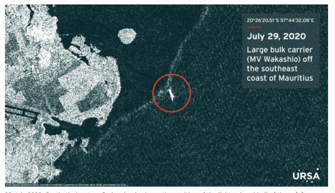
Looks like she has broken in two (As predicted):
The two tugs Boka Summit and Expedition appeaser to have lines on the Fwrd part, but not yet pull it off the reef.Maybe not full separated yet??
If they had erroneously set their way-point South off Réunion Island, instead off its twin sister Mauritius Island, they did not see any traffic in front of them (between their ship on the wrong path and the rather empty side of Mauritius Island). All is OK !
No need to investigate further, or to have a proper lookout >120 miles from the way-point…
When plotting larger targets on a medium range scale, the display should be periodically switched to a shorter range, and the clutter controls adjusted, to search for less distinct targets.
That is a fault that often is made, to keep the radar switched too long to a large range. You can then easily miss close targets that can hide in the ‘noise’ around the center spot.
With rain it was standard order to also switch on the 10 cm radar which can better penetrate rain squalls etc and so detect targets that would be invisible on a 3 cm radar.
Of the three, ECDIS, radar and visual the shore lights are going to provide the weakest indication that the ship was too close, the lights would have been on the stbd bow where they were expected.
Some skill / experience would be needed to evaluate the lights in contrast to the simple track line / ship icon on the ECDIS.
Another point about the ECDIS is the an alarm should have sounded when the safety contour was crossed.
The five mandatory alarms (as per IMO ECDIS
Performance standards) are: crossing safety contour,
deviation from route, positioning system failure,
approach to critical point and different geodetic
datum.
Don’t forget the humans.
BBC World News has wide coverage of the situation:
wafi to wafi, damn its dangerous out here with all those professionals on the large ships.
As they say, even the guy who came last in medical school is still called, “doctor”.