Possible but very unlikely there was a problem with the GPS signal received or processed on board.
Because the course change towards Mauritius was made days before it seems more likely that the track-line was laid out in advance rather than a Costa Concordia style fly-by.
The ship may have been inside the planned track, the planned track may have had insufficient UKC due to either a failure to check the charted depths or the charted depths may be in error due to old surveys.
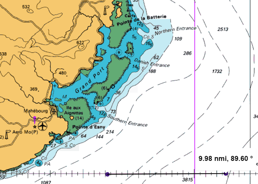
They drove the ship within a couple of ship lengths of a protruding reef, not into uncharted shallows. The charted position of the reef would have to have been way off but even then it wasn’t a close quarters situation where they had to get anywhere within miles of it.
A Volvo Ocean Race Team Vesta type error is another possibility. IIRC in that case the route was plotted by an experienced navigator but on the wrong scale.
As to driving up on the reef, I’m not sure what happened, obviously they were too close.
The current position on the reef may not be the same position as the initial grounding.
Chart datum error is another possibly.
One reason to think the grounding was a result of navigation error and not a complete loss of situational awareness is the warning by VHF. The captain was reported to be in the wheelhouse at the time. The captain’s response to the warning that the ship was standing into danger was to immediately deny that was the case and then make a slight course adjustment away from the reef.
What made him believe he was in safe waters? The slight course adjustment implies some understanding of the ship’s position.
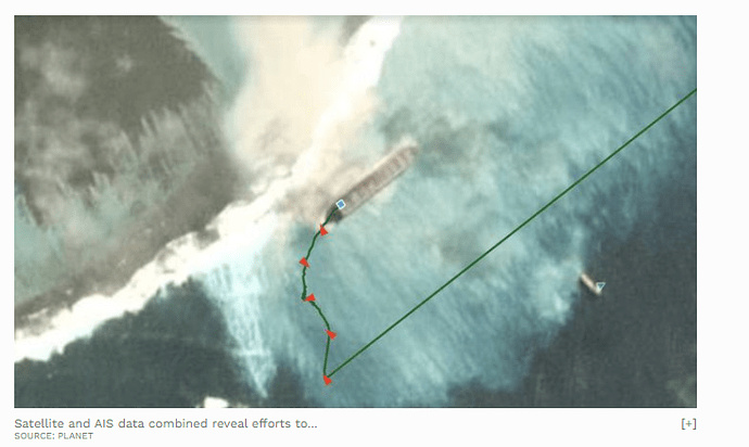
Where there is a 90 degree turn in the AIS track line overlaid on the satellite imagery would appear to be where the ship made initial contact. The angle in this photo shows how close they were to land.
Yeah, so the actual ship’s path was about a ship length or so further out then the position in the photo. Which is obviously too close.
Were they inside the planned track? If they were on the planned track what made the person who laid the track-line down think that track had sufficient UKC?
Another point would be the Doppler. If it was operating and set properly it would have been sounding an alarm or at least showing an insufficient UKC.
Could they have plotted their voyage to the false island?
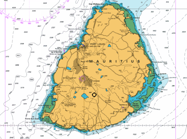
Passing South of the French Réunion Island instead of South of Mauritius Island?
Both islands have nearly the same shape and surface, distanced 120 NM.
The density chart from the Malacca Strait to the Cape Aghulas shows the majority taking a great circle to the South off Mauritius, and once there, slightly correct to starboard.
A plotted great circle, from the Malacca Strait to the South off Réunion Island, passes just over the Southern part of Mauritius Island with this ugly reef !
It looks like the ship is here in a position perpendicular to the reef. The last AIS report was send on 5 August with a course of 149° probably turned some more after that to… a position alongside the reef. In that parallel position she is locked and probably lost.
In the beginning, when she still was in that perpendicular position, a possibility could have been to deballast the ship especially to lighten the forward part resting on the reef and then giving full astern. Perhaps they did that but this doesn’t show easily. Well, under the circumstances worth a try.
Beep, Beep, Beep from a few devices,radio calls,radar, lights on the beach.etc,etc. Must have been one helluva party abruptly ended. Bummer. I usually take a side on the mariners behalf if I can. This unfortunately isn’t one of them. Captain on bridge “Noticed we weren’t moving”. ship that big coming to a complete stop was surely felt in all corridors, and made a bit of racket. Most certainly the cake fell over.
Well, I’ll bite.Why a Japanese vessel as opposed to USA and/or Russian, both Koreas, etc. etc. They fucked up sir, perhaps I am narcissistic in my opinion, Why so suspicious?
Indian Ocean is also the “home” of a major US base at Diego Garcia. Could that have something to do with it? It’s only 1632 n.miles away from Mauritius (A lot closer than China)
Could CIA, or some other of the numerous US intelligence agencies, have something to do with it??
FYI; A lot of the people displaced from there to give space for the US base lives in Mauritius. Besides, Mauritius lays claim to the island of Diego Garcia.
Who knows, everything is open to conspiracy theories these days.
Your theory makes perfect sense. The truth is so obvious, it’s a wonder no one else can see it. It’s a devious Trumpian scheme to embarrass Japan and distract the democrats so he can steal the upcoming elections.