A Bering Sea Superstorm is now developing, partially from the former , and will whip up hurricane-force winds in parts of Alaska’s Aleutian Islands as well as giant waves in the Bering Sea.
The ex-Nuri has joined up with the polar jet stream and a very strong disturbance in the mid-latitude belt of westerly winds, leading to explosive development of low pressure.
On Saturday morning, U.S. time, the low was analyzed to have a pressure of 924 millibars, which make it the strongest low-pressure system ever observed in or near Alaska since October 25, 1977, when a 925 millibar pressure reading was recorded on a ship docked at Dutch Harbor, Alaska. This system may also potentially be one of the lowest sea-level barometric pressures ever observed on Earth outside of tropical cyclones and tornadoes.
<
(MORE: )
For reference, the lowest central pressure of Hurricane Andrew (1992) was 922 millibars. Despite the potential of a similar pressure at its peak, wind speeds in extratropical cyclones such as the upcoming storm are much lower than hurricanes, because the pressure gradient is spread out over a much larger area than in a hurricane.
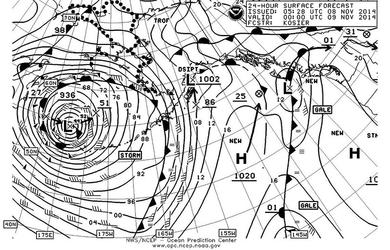
BackgroundModel Forecast: Bering Sea Superstorm
Model Forecast: Bering Sea Superstorm
Forecasts from both the European (ECMWF) and American (GFS) computer models have consistently predicted this extremely powerful non-tropical storm to bottom out at peak intensity below 930 millibars over the western Bering Sea, near the western Aleutian Islands of Alaska early Saturday.
BackgroundSatellite, Current Winds
Satellite, Current Winds
INTERACTIVE SATELLITE LOOP
On Saturday morning, sustained winds of more than 50 mph were reported in the far western Aleutians, with gusts over 65 mph.
As of Friday afternoon ex-Nuri was deepening quickly south of Russia’s Kamchatka Peninsula. Sustained winds first topped 40 mph around 5 a.m. AKST in , located in the far western Aleutians, and were by late morning.
Potential Impacts
The map below shows the European model wind speed forecast for Saturday night, with the darkest red colors showing the strongest wind speeds in the western Aleutians and east of Russia’s Kamchatka Peninsula.
BackgroundModel Wind Forecast: Bering Sea Superstorm
Model Wind Forecast: Bering Sea Superstorm
A large swath of very strong sustained winds, at times hurricane-force, will howl over the western Aleutian Islands of Alaska and adjacent Bering Sea.
The National Weather Service in Anchorage has issued a hurricane force wind warning for the waters surrounding the far western Aleutians as well as parts of the southwestern Bering Sea. Sustained winds could reach 80 mph in those areas.
Meanwhile, a high wind warning has been issued for the far western Aleutians themselves until midday Saturday. In addition to the strong sustained winds pictured on the map above, there could be localized gusts of 90 mph or higher, especially where rugged terrain enhances the winds. The strongest winds will be southerly to southwesterly in origin.
Fortunately, the storm is forecast to lose some of that ferocity later in the weekend, but may remain somewhat stalled over the Bering Sea into Sunday or Monday.
These strong winds, coupled with the potential long duration of this storm, will whip up giant waves over parts of the Bering Sea and north Pacific Ocean.
BackgroundWave Height Forecast: Bering Sea Superstorm
Wave Height Forecast: Bering Sea Superstorm
Wave heights will likely top 45 feet near the western Aleutian Islands through Saturday, making for very dangerous conditions for all marine vessels not protected.
Swells around 22 feet may reach the eastern Aleutians and Pribilof Islands, including , Saturday into Sunday. St. Paul (population: 453) is notorious for intense storms, with a harbor that is susceptible to southwest winds, according to the .
A Jayhawk helicopter crew was sent by the U.S. Coast Guard to Cold Bay, Alaska, and the Cutter Munro was put on alert to help boaters stranded in the storm, if needed, .
As these large swells finally reach the coast of western Alaska, some minor coastal flooding and erosion is possible Sunday into Monday.
(MORE: NWS Alaska Weather Alerts)
Areas farther east, including the city of Anchorage will see a band of rain and snow with the cold front Sunday, along with some occasional wind gusts over 40 mph particularly on the southern coast of the Kenai Peninsula, the mouth of Prince William Sound, and Kodiak Island.
(FORECAST: Nome | Anchorage)
November 2011 Deja Vu?
Bering Sea Superstorm 2011
MODIS visible satellite image of the Nov. 8, 2011 Bering Sea Superstorm taken at 2:45 p.m., local time. (Jesse Allen - NASA Earth Observatory)
ENLARGE
Coincidentally, this storm is developing three years to the calendar day after a 2011 storm hammered parts of western Alaska with high winds and coastal flooding.
At least 37 Alaskan communities reported at least some form of damage, including storm surge flooding, blown-out windows, roof damage, and debris on roads.
Winds gusted to 84 mph in Wales, Alaska. A storm surge of 10 feet, along with whiteout conditions, hammered Nome, the largest city in northwest Alaska, overtopping a sea wall and covering a sea-front road with large rocks.
As a result, Nome missed its final fuel delivery for the winter. Two months later a Russian tanker, escorted through hundreds of miles of sea ice by a U.S. Coast Guard icebreaker, delivered the 1.3 million gallons of fuel needed to get the town through spring.
, a village of 460 residents lying on a narrow spit of land facing the Chukchi Sea, experienced a 5.5 foot storm surge. Most of the town’s residents were evacuated to a local school.
No fatalities or injuries were directly related to the storm, a tribute to early warning and good emergency preparedness in this sparsely populated area.
So, what are the potential differences in this upcoming case, compared to the 2011 storm?
Bering Sea Superstorm 2011
Pacific surface analysis on Nov. 8, 2011 at 7:10 p.m. PST. Center of 2011 Bering Sea Superstorm depicted by blue arrow, analyzed at 943 millibars. (NOAA/OPC)
ENLARGE
- Peak intensity farther west: The central pressure of the 2011 storm dipped to 943 millibars. Of course, it’s the gradient in pressure that drives winds. At the same time, a 1031 millibar surface high was centered over Alaska’s northeast interior. This intense pressure gradient aligned over the west coast of Alaska drove the high winds.
In this case, the central pressure is lower (stronger) than 2011, but the storm’s position at peak strength, and peak pressure gradient will be farther west in 2011, thus the strongest winds appear most likely over the western and central Bering Sea and western Aleutians, rather than the west coast of Alaska.
- This storm will linger longer: The 2011 storm moved northeast, then north from west of the Aleutian Islands, to the Bering Sea, to the Chukchi Sea in the span of a couple of days. While surge flooding was significant, this lack of duration kept the flooding from being worse.
The current storm may linger in the Bering Sea, though in a weakened state from its late Friday/Saturday peak, into Monday.
Wave heights over the southern and western Bering Sea and adjacent north Pacific Ocean from late Friday into Saturday may exceed those seen in the 2011 storm, however, due not only to the more intense storm, but also the longer duration of high winds.
While the strongest winds will remain well to the west in this case, the duration of southerly winds and the subsequent swells generated may still lead to at least some coastal flooding along the west coast of Alaska.
Sig Hansen, captain of the fishing vessel Northwestern, featured in the television series “Deadliest Catch,” told ABC News that folks in Alaskan waters are bracing themselves for what Typhoon Nuri’s remnants may bring, including 50-foot waves.
The harsh weather may hit the Aleutian Island chain in Alaska as early as Friday. Hansen has been fishing King Crab, northeast of Dutch Harbor in the Bering Sea, about 300 miles away.
“Right now, the weather’s decent. We’ve been watching the weather reports, and so that’s what’s got us kind of skittish,” he said. “We’ve had other reports coming in, which are very strange, like 25-knot winds with 30-plus foot [waves]. It’s just very uncommon, so you know something’s coming. It’s just a warning sign for now. We’re just on pins and needles here.”
Alaska Mayor Vetoes Law Aimed at Protecting Moose
PHOTO: Wednesday morning wake up to wind chills. Single digits in the Northern Plains, teens from Texas to Cleveland, and 20s all the way down to Louisiana, Mississippi, and Tennessee.
ABC News
PHOTO: Wednesday morning wake up to wind chills. Single digits in the Northern Plains, teens from Texas to Cleveland, and 20s all the way down to Louisiana, Mississippi, and Tennessee.
“We’re just keeping our fingers crossed that it doesn’t push in a more easterly direction, and bring those 70-knot winds this way,” he said. “Right now, we’re at battle stations. In other words, we need about a 24-hour notice to get our boats, our gear, and get onto shore. You don’t want to be out here.”
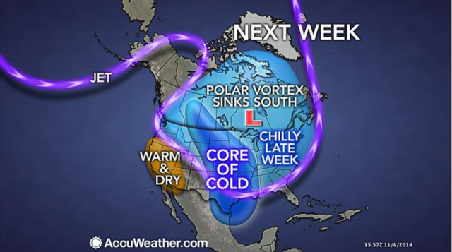
PHOTO: This very strong storm will also indirectly affect the mainland US in the form of extreme temperatures.
ABC News
PHOTO: This very strong storm will also indirectly affect the mainland US in the form of extreme temperatures.
“From what I’m hearing, we haven’t been through anything like that before, at least not in my lifetime,” he said. “And I don’t want to. We’ve seen 50-foot waves, we’ve seen 120-knot winds. I’ve been out in stuff like that. But the difference is, if it’s going to hit here with that kind of power, you don’t know the frequency of the waves. We don’t know how it’s going to affect the ocean differently. I don’t want to stick around to find out.”
Kip Wadlow, U.S. Coast Guard spokesperson in Juneau, Alaska, said emergency crews are standing by with helicopters and a 378-foot cutter. The emergency crews were already ready for duty to assist with the crab fishing season.
“These assets are standing by to provide assistance if called upon. We are working with federal and state tribal partners to keep an eye on the storm,” Wadlow said.
PHOTO: It’s time for fishermen to get out of the seas as fast as possible! Look at these predicted wave heights for Friday night and Saturday! Waves over 50ft are very possible from this storm.
ABC News
PHOTO: It’s time for fishermen to get out of the seas as fast as possible! Look at these predicted wave heights for Friday night and Saturday! Waves over 50ft are very possible from this storm.
Jeremy Zidek, from Alaska’s division of homeland security and emergency management, has warned communities about possible weather dangers along western Alaska, including many native tribes and the Alaska Village Council Presidents.
PHOTO: Remnants of what was once “Super Typhoon Nuri” in the West Pacific has now transformed into an extratropical storm as it moves northeast towards Alaska.
ABC News
PHOTO: Remnants of what was once “Super Typhoon Nuri” in the West Pacific has now transformed into an extratropical storm as it moves northeast towards Alaska.
“Because they are small, remote communities, they are in tune with the weather and folks are taking precautions and taking steps to protect people in those communities,” Zidek said.
Zidek said emergency services generally don’t warn people to evacuate these small communities, because the distances to travel may cause greater dangers than taking shelter in place.
“This is a normal way we go about handling these storms in Alaska,” he said.
In many of these small communities, the local school is the hub.
“People will go up to the school, which is normally built on higher ground with backup systems. In some communities of maybe 120 people can fit in the school and they are a tight-knit community,” Zidek said.
PHOTO: Mount Moffett on Adak Island, part of the Aleutian Island chain in Alaska, May 15, 2014.
Brian Hoffman/Flickr
PHOTO: Mount Moffett on Adak Island, part of the Aleutian Island chain in Alaska, May 15, 2014.
Chris Plaisance of seafood company UniSea Inc., said his colleagues in the city of Unalaska, Alaska, near Dutch Harbor are protected by nearby mountains.
“We should not experience winds much more than 40 miles per hour to hit this weekend. It sounds like the islands that are farther west will take the brunt of the storm,” he said.
Clarification: Alaska is preparing for remnants of Typhoon Nuri. The system is no longer a typhoon.
Sig Hansen, captain of the fishing vessel Northwestern, featured in the television series “Deadliest Catch,” told ABC News that folks in Alaskan waters are bracing themselves for what Typhoon Nuri’s remnants may bring, including 50-foot waves.
The harsh weather may hit the Aleutian Island chain in Alaska as early as Friday. Hansen has been fishing King Crab, northeast of Dutch Harbor in the Bering Sea, about 300 miles away.
“Right now, the weather’s decent. We’ve been watching the weather reports, and so that’s what’s got us kind of skittish,” he said. “We’ve had other reports coming in, which are very strange, like 25-knot winds with 30-plus foot [waves]. It’s just very uncommon, so you know something’s coming. It’s just a warning sign for now. We’re just on pins and needles here.”
Alaska Mayor Vetoes Law Aimed at Protecting Moose
PHOTO: Wednesday morning wake up to wind chills. Single digits in the Northern Plains, teens from Texas to Cleveland, and 20s all the way down to Louisiana, Mississippi, and Tennessee.
ABC News
PHOTO: Wednesday morning wake up to wind chills. Single digits in the Northern Plains, teens from Texas to Cleveland, and 20s all the way down to Louisiana, Mississippi, and Tennessee.
“We’re just keeping our fingers crossed that it doesn’t push in a more easterly direction, and bring those 70-knot winds this way,” he said. “Right now, we’re at battle stations. In other words, we need about a 24-hour notice to get our boats, our gear, and get onto shore. You don’t want to be out here.”
PHOTO: This very strong storm will also indirectly affect the mainland US in the form of extreme temperatures.
ABC News
PHOTO: This very strong storm will also indirectly affect the mainland US in the form of extreme temperatures.
“From what I’m hearing, we haven’t been through anything like that before, at least not in my lifetime,” he said. “And I don’t want to. We’ve seen 50-foot waves, we’ve seen 120-knot winds. I’ve been out in stuff like that. But the difference is, if it’s going to hit here with that kind of power, you don’t know the frequency of the waves. We don’t know how it’s going to affect the ocean differently. I don’t want to stick around to find out.”
Kip Wadlow, U.S. Coast Guard spokesperson in Juneau, Alaska, said emergency crews are standing by with helicopters and a 378-foot cutter. The emergency crews were already ready for duty to assist with the crab fishing season.
“These assets are standing by to provide assistance if called upon. We are working with federal and state tribal partners to keep an eye on the storm,” Wadlow said.
PHOTO: It’s time for fishermen to get out of the seas as fast as possible! Look at these predicted wave heights for Friday night and Saturday! Waves over 50ft are very possible from this storm.
ABC News
PHOTO: It’s time for fishermen to get out of the seas as fast as possible! Look at these predicted wave heights for Friday night and Saturday! Waves over 50ft are very possible from this storm.
Jeremy Zidek, from Alaska’s division of homeland security and emergency management, has warned communities about possible weather dangers along western Alaska, including many native tribes and the Alaska Village Council Presidents.
PHOTO: Remnants of what was once “Super Typhoon Nuri” in the West Pacific has now transformed into an extratropical storm as it moves northeast towards Alaska.
ABC News
PHOTO: Remnants of what was once “Super Typhoon Nuri” in the West Pacific has now transformed into an extratropical storm as it moves northeast towards Alaska.
“Because they are small, remote communities, they are in tune with the weather and folks are taking precautions and taking steps to protect people in those communities,” Zidek said.
Zidek said emergency services generally don’t warn people to evacuate these small communities, because the distances to travel may cause greater dangers than taking shelter in place.
“This is a normal way we go about handling these storms in Alaska,” he said.
In many of these small communities, the local school is the hub.
“People will go up to the school, which is normally built on higher ground with backup systems. In some communities of maybe 120 people can fit in the school and they are a tight-knit community,” Zidek said.
PHOTO: Mount Moffett on Adak Island, part of the Aleutian Island chain in Alaska, May 15, 2014.
Brian Hoffman/Flickr
PHOTO: Mount Moffett on Adak Island, part of the Aleutian Island chain in Alaska, May 15, 2014.
Chris Plaisance of seafood company UniSea Inc., said his colleagues in the city of Unalaska, Alaska, near Dutch Harbor are protected by nearby mountains.
“We should not experience winds much more than 40 miles per hour to hit this weekend. It sounds like the islands that are farther west will take the brunt of the storm,” he said.
Clarification: Alaska is preparing for remnants of Typhoon Nuri. The system is no longer a typhoon.