El Faro - What was the Captain Thinking is the Wrong Question

[QUOTE=Kennebec Captain;195795]I know a captain that was on the JAX/SJU run for 20+ years, he told me he could easily see this happening to him. I feel the same way, the way things unfolded, the changing forecast, could of happened to me easy. [/QUOTE]

However honest K.C., you’ll have to agree that that is a very scary admission, because it basically implies that under current practices, such an accident is likely to occur again.

[QUOTE=Mat;195804]However honest K.C., you’ll have to agree that that is a very scary admission, because it basically implies that under current practices, such an accident is likely to occur again.[/QUOTE]

Well, I shouldn’t say it could happen easy, I should say it’s easy for me to see how it could happen. Like getting dealt two royal flushes in a row. I know it can happen because I’ve been dealt each one of the cards at some point, but never at the same time. So I can see that it’s possible, just not likely.

Aviators have a saying, they say they hope someone’s experience bucket fills up before their luck bucket runs out. Over the years stuff happens that by itself is no harm but if it happened in conjunction with other things that have happened… so over the years you learn to defend against each thing.

For example the weather program. If the “show tropical cyclones” button isn’t selected somewhere buried in the menu TC won’t show up. Also if the GMDSS is not set up properly it will not print out weather for your area.

What are the chances that you’ll get a bad alignment, TC that’s going to affect the ship, TC not selected on the WX program, GMDSS set up wrong, signs missed because the crew was distracted by other tasks? Very little chance all at the same time but when someone is in disbelief that such a thing could happen, I think, I can see how.

OK. That sounds better. Don’t want to do yourself a disservice!

[QUOTE=Kennebec Captain;195806]Well, I shouldn’t say it could happen easy, I should say it’s easy for me to see how it could happen. Like getting dealt two royal flushes in a row. I know it can happen because I’ve been dealt each one of the cards at some point, but never at the same time. So I can see that it’s possible, just not likely.

Aviators have a saying, they say they hope someone’s experience bucket fills up before their luck bucket runs out. Over the years stuff happens that by itself is no harm but if it happened in conjunction with other things that have happened… so over the years you learn to defend against each thing.

For example the weather program. If the “show tropical cyclones” button isn’t selected somewhere buried in the menu TC won’t show up. Also if the GMDSS is not set up properly it will not print out weather for your area.

What are the chances that you’ll get a bad alignment, [B]TC that’s going to affect the ship, TC not selected on the WX program, GMDSS set up wrong[/B], signs missed because the crew was distracted by other tasks? Very little chance all at the same time but when someone is in disbelief that such a thing could happen, I think, I can see how.[/QUOTE]

Did the ship have Direct TV with the Weather Channel ?

[QUOTE=AHTS Master;195811]Did the ship have Direct TV with the Weather Channel ?[/QUOTE]

The crew mentions getting the Weather Channel, not if they had Direct TV or not.

With regards to the BVS, I don’t use that one but I use a similar program

This program itself can not be used for creating a voyage plan because it lacks the details needed for navigation, depths aids, TSS, the land masses are crudely drawn. Waypoints entered into the WX program, a departure time and a speed are entered, the speed can be rpm or kts.

When the weather data arrives the file gets loaded into the program, the info is in “layers”, surface winds, pressure, wave / swell height and direction, currents, fronts can be seen. When the program is advanced in time the ship icon can be seen advancing along the track-line and the expected weather can be read from a screen window. The ship’s speed is adjusted by the program according to the forecast conditons. For example if head winds or swell is encounted the speed of advance adjusts accordingly.

The time of arrival at each waypoint can be seen as can the ETA. The track can be adjusted by clicking and dragginig the waypoints with the mouse and the ETA can be seen changing. Also an optimum route can be found and so forth.

The program is far quicker, easier and more convenient than the paper wx charts, the current, 24 hr, 48 hr each on a different sheet. If the ship encounters a low pressure system the track can be adjusted around the desired max wave height contour. Or the parameters can be entered, max wind and wave heights and the program will create a track-line for you.

The program is far more precise then TV or NWS weather because it centred on the ship’s postion or expected future position. All the GMDSS equipment is still required but the information from traditional sources tends to get neglected unless the process used prior are kept in place.
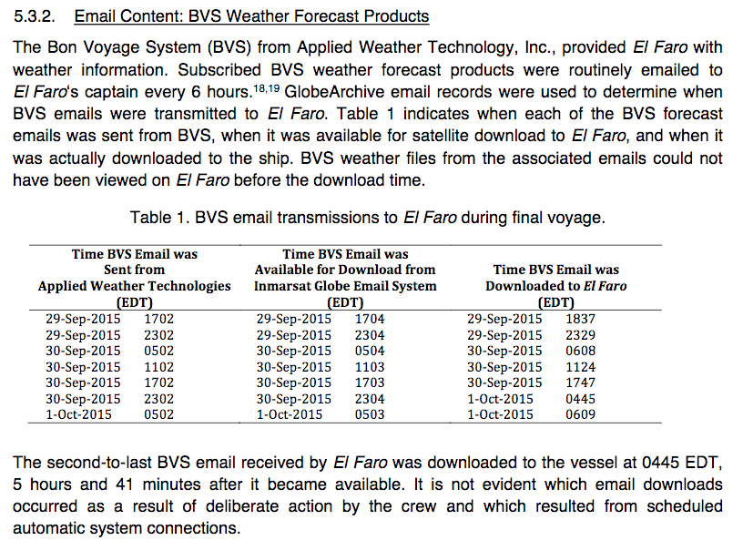
Has anyone got any comments on the following oddities re. weather data in the the reports:

  1. https://dms.ntsb.gov/public/58000-58499/58116/598576.pdf

Most of this document (Attachment 24 concerning BVS data delays) is blanked out. Why?

  1. https://dms.ntsb.gov/public/58000-58499/58116/598562.pdf

The ship supplied one very detailed voluntary weather observation report (Attachment 11) at 14:00 on the 30th Sept. Why was this the only one? Data of this kind would have been invaluable in assessing their position relative to the centre of the storm, but only if it was recorded regularly, so trends and changes would be obvious, and easily interpreted. Was this data logged somewhere else, even if a report wasn’t sent? Would they have been routinely recording it electronically somewhere? Or would it have been logged longhand in the logbook? They were obviously capable of making accurate wind direction & speed observations without a functioning anemometer.

  1. https://dms.ntsb.gov/public/58000-58499/58116/598654.pdf Extract from Electronic Data Report

    Is it really possible that no one on board downloaded the 23:00 hr BVS data until 04:45 (a delay of nearly six hours), at a time when they knew that they were closing with a hurricane (it happens that it was downloaded just before the Captain returned to the bridge on the morning of the 1st)?
  • The single WX obs that was sent was mentioned at the hearing. It was mentioned that the postion falls inland on the Island of Cuba, I just checked and that’s correct.

  • the download at 0445, that makes sense if the captain did not check the weather after 2300 hrs and then checked at 0445 hrs.

At the risk of making a mountiain out of a molehill this seems like a telling point to me. The wx update files come in by email. I relieved a captain one time. The ship had a similar set-up. Email was rcvd in the captain’s office but the wx program was instaled in the capt’s office and on the bridge. That captain told me that he didn’t forward the wx data to the bridge until he “reviewed them”. He repeated that several times, making a point. I took that as a desire to control information. Instead I set up MS Outlook (using a “rule”) so it forwarded the email containing the data to the bridge when received. More eyes the better.

wrt the WX observations. The most common routine I"ve seen is that the wx is observed every 4 hours and logged. Typically if wind speeds are over f-7 then obs are taken and logged every hour. Some ships send the 6 hour synoptic weather to the NWS and some don’t.

CAPT
13:17:04.8 13:17:12.1 “From here– here on out log the weather. just um wind direction and force– barometer. every hour.”

Upcoming 60 minutes report

http://wgme.com/news/local/ntsb-investigator-recounts-listening-to-the-last-words-of-el-faro-crew

Here the 2/M seems to think the wind is going to back to the stbd quarter - which would be if they were going to pass south of the center

2M
03:24:35.8
03:24:49.9
I think it’s shifting. cause that weather report say tha– uhh– westsouthwest
wind which we were not getting but I think its starting to shift
west and now its coming back around. we’re gunna start getting it on
the starboard side.

At watch change at 0400 hrs the course is 110 degrees

Ship’s heeling to stbd - wind would have been on the port bow.

CM
03:48:01.1
03:48:04.8
I assume that we’re heelin’ to starboard (must be blowin’) port to
starboard.

If they thought they were to the south of center the wind would have been on the port quarter, expecting it to back, come around aft then stbd

CM
04:14:34.6
04:14:37.3
(but) our forecast had it comin’ around to starboard.
CAPT?
04:14:38.0
04:14:38.9
the wind?
CM
04:14:39.1
04:14:39.6
right.
CAPT
04:14:39.4
04:14:40.6
it will eventually.

But then when the list becomes a problem the capt decides to steer into the wind - they steer 060-

CAPT
04:43:22.4
04:43:24.0
gunna steer right up (in to it).

CAPT
04:43:25.8
04:43:28.7,
wants to take the list off. so let’s put it in hand steering.

CAPT
04:50:40.5
04:50:43.5
(wanna/why don’t ya) see if you can steer that course right there. zerosix-zero.

If they are steering 060 and expect the wind to veer round to the stbd side they must understand they are to the north of the center?

CM
05:01:02.0
05:01:18.9
expecting the wind to come around here to the bow and then to the
starboard side. I can still– I can still see the spray foam to the
starboard. we’re still heelin’.

CAPT
05:03:30.8
05:03:54.8
That– that’s fine– but here’s the thing– you got two G-P-Ss– you got
five G-P-Ss– you gunna get five different positions. you got one
weather program (and I use/and use) B-V-S and that’s what I (sent) up
here * we’re gettin’ conflicting reports as to where the center of the
storm is.

But then the capt says they are on the back side,

CAPT
05:18:39.4
05:18:41.8
we’re on the back side of it.

This is ambiguous

CAPT
05:22:07.3
05:22:16.7
that’s what’s forecast on B-V-S that’s (our) weather system so we’re
goin’ * * * . (get on the other side/be around the south side).

If I’m interpreting the transcript correctly it seems that the last chance they had to take evasive action was at 01:20, when 2M called the Captain prior to changing course at a waypoint. I think she suggests they they steam due south, through the Crooked Island channel. But Captain tells her to go with the original plan, and bring the ship onto a heading of 116 deg. This basically heads them straight at the storm (as the helmsman realizes). Although they had been in the dangerous semi-circle all along, their distance from the centre up until that point meant that conditions weren’t that bad. Had they turned south, they could probably have steamed with the wind on their stern, avoided the worst of it, and made it across the ‘T’. But heading the other way meant conditions would inevitably deteriorate. If this is correct, it gives much food for thought.

[QUOTE=KPChief;195830]Upcoming 60 minutes report

http://wgme.com/news/local/ntsb-investigator-recounts-listening-to-the-last-words-of-el-faro-crew[/QUOTE]

It’s on now.

Well anyone got thoughts on the 60 mins piece?

It really sucked. Although - Thank you 60 minutes / CBS for dedicating some time to the tragic event. Prayer’s to everybody affected.

[QUOTE=Kennebec Captain;195826]wrt the WX observations. The most common routine I"ve seen is that the wx is observed every 4 hours and logged. Typically if wind speeds are over f-7 then obs are taken and logged every hour. Some ships send the 6 hour synoptic weather to the NWS and some don’t.[/QUOTE]

Only one was transmitted. But should be every three hours per SOLAS when within 300 nm. 3M noted this interval early in transcript sounded Ike he was going they a checklist

Yes, the 180 through Crooked Island Passage seems to be what she had planned out. She worked it out shortly after relieving the watch.

2M
00:19:56.6
00:20:28.8
well right now on this course we’re fine. it’s if we go south. try and get
away from it. and I was looking at it. we can try to connect with the Old
Bahama Channel if we I don’t know one thirty (just/so) go due south.
that’s– that’s where we get into where it’s kinda shallow and there is no
wiggle room. well there’s a little bit we’ll just have to see * it.

2M
00:41:08.1
00:41:47.3
well we wouldn’t– we wouldn’t have to worry about it until two o’clock.
our tentative position– our D-R for zero two hundred gets us in a good
angle– in a good spot that we can alter course south to one eight six
and that course line if we stay on that keeps us five miles away from
any kind of shallow area which is enough room. (not a lot of/so) wiggle
room but right now where we’re going we don’t have much wiggle room
right now. we got land on either side of us. well coming up to either side
of us.

Likely it would have been a good move, better than what they did anyway. The only other move looks like back up the way they came with the wind ahead or on the stbd bow.

Agreed. Seems to tally with what they had on 60 Minutes too.

It was really sad that the Mate asked for Splenda is his coffee instead of sugar, that meant he still had hope to see another day. That’s what I got out of it.

[QUOTE=Mat;195833]If I’m interpreting the transcript correctly it seems that the last chance they had to take evasive action was at 01:20, when 2M called the Captain prior to changing course at a waypoint. I think she suggests they they steam due south, through the Crooked Island channel. But Captain tells her to go with the original plan, and bring the ship onto a heading of 116 deg. This basically heads them straight at the storm (as the helmsman realizes). Although they had been in the dangerous semi-circle all along, their distance from the centre up until that point meant that conditions weren’t that bad. Had they turned south, they could probably have steamed with the wind on their stern, avoided the worst of it, and made it across the ‘T’. But heading the other way meant conditions would inevitably deteriorate. If this is correct, it gives much food for thought.
[/QUOTE]
Is BVS really the right instrument when inside a rapidly evolving situation like here?

The blue track is BVS, the red one is SafetyNet, booth available to El Faro at about 0200 EDT.
The purple hurricane symbol is the NHC Intermediate Public Advisory, and the black one is the real position, determined much later.

With the information available at 0200, heading South to the Crooked Island passage would certainly have been less dangerous. However, BVS as single information source permitted to dream and hope…

With hindsight, it is not given that they would have been safe. Joaquin went even more southerly than this forecast. Landfall on Samana Cays (the island south of the red 0800 position) was at 0800 EDT.

I am really curious how the experts will sort out all this stuff…