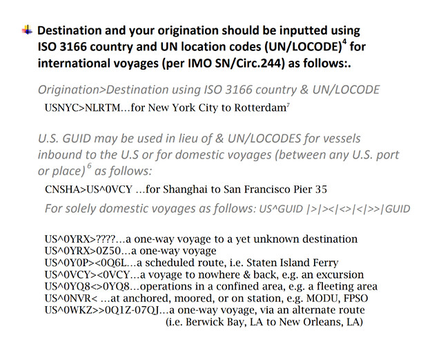
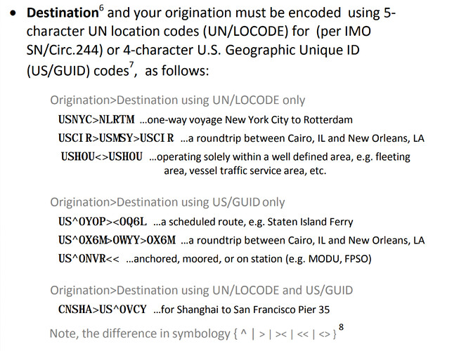
Do you follow USCG and IMO guidance on AIS programming?
While sailing through the English Channel, my ship was recently hailed by two passing ships on VHF radio because they did not know what LoCodes are and did not recognize the IMO format showing port of origination AND port of destination. Our AIS was correctly programmed… evidently, still an uncommon occurrence at sea.
The USCG AIS Encoding Guide states:
"AIS is a valuable navigation safety radio communication tool. However, its effectiveness is undermined by the broadcast of inaccurate, improper or outdated data. Users are reminded that U.S. regulations (33 CFR 164.46) require that it be maintained in effective operating condition, which includes accurate input and upkeep of all AIS data parameters.
Continual failure to do so may prompt civil penalty action. To avoid penalties, always ensure your AIS is up-to-date and encoded according to this Guide."
Very few vessels actually follow the USCG guidance and IMO/SOLAS guidance on this. My read is that the guidance is incorporated into 33CFR by reference, and is therefore required. Any thoughts on this by anyone who really knows?
Other mariners I have sailed with feel strongly that ONLY the Destination should be entered, and NOT the port of origin and that LoCodes are too confusing so dont use them until forced to do so.
I see it as an issue that includes the important needs of VTS operators who use port of origination AND destination data to accurately identify, track, and distinguish vessels transiting thier areas.
So, back to my question… do you use locodes and encode your AIS like this “US GAL>MX ATM”, or like this “Altamira MX”?
AFAIK the field is destination only, not departure port. The vessel can be identified and distinguished by IMO number alone. We used the port codes and kept a list nearby.
In your example MX ATM.
1 Like
Okay, so what about the USCG guidance and the civil penalties they describe? What about IMO guidance… all say the same thing.
You were asking about practice, I don’t recall seeing the departure port in another ships AIS.
If the CG threatens with a fine I would change the practice and file the letter of warning with the others.
1 Like
FWIW, I’ve seen ships with all sorts of crappe in that block - including the from > to codes as you describe, though that’s uncommon. Knowing the destination is quite useful to us - it tells me what to expect up ahead.
What really chafes me are the number of vessels (and these are NOT yachts) with what might be their home port, with an ETA 6 months or a year in the future. I also see lots with just their LAST destination and an ETA a few days old.
A recent trend are large (100’+) Motoryachts with no AIS at all - if you call them & ask, they say they’ll “look into it”. Apparently these guys DON’T want a record of where they (or perhaps their customers) have been.
1 Like
Agree, The IMO number is unique to every SOLAS compliant vessel , it is literally engraved on the hull of the vessel. It will never change unlike names and owners.
1 Like
On the US West Coast I see both just destination and orig > dest on commercial (Class A) vessels. Sometimes I see more detailed destination info like anchorage or berth on inbound vessels. Tugs and other work boats generally have something local that doesn’t change. AFAIK recreational vessels with Class B transponders don’t have this as an editable field.
1 Like
Yeah, I’ve always kept a locode list near the GMDSS station too. I see your points. I imagine the job of a VTS operator must be difficult in areas of dense traffic. Hard to remember one cargo onboard from the next by just a name and IMO number. I guess they wanted orgination and destination to help them remember which is which? As in “Hey Boudreaux, you seen dat one from Houma with all that ammunition onboard? I had him on my screen, but I cant find him now?”
I started this thread just wondering how important mariners feel it is to follow USCG guidance on this to the letter these days. Thanks again for your thoughts.
That is the case for sure - I can’t program that stuff at all. I have seen plenty of obvious errors like destination Baltimore when the ship is headed for Norfolk and one ship was going sideways. I called them and told them their compass heading data was messed up, the ship was going north at 15 knots with the “AIS bow” pointed due east.
They have it all right, it is just in stealth mode (receive only).
The CG can impose fines and take action against a mariner’s license but in this case I’ve never seen any USCG guidance in this matter. Not saying it doesn’t exist, just have never seen any guidance.
Ultimately instructions have to make it into a pre-departure check-list or it’s not going to happen with any consistency. Even than it’s not a sure bet.
This is from the USCG encoding guide dated 05-01-2012. (It might have begun before that but this is the earliest version I can find.)
This appears to be the most current version:
AISGuide.pdf (248.3 KB)
Here’s the applicable section:
Those definitions and destinations are so easy to read, no need for ANOTHER reference book on the bridge.
I am thinking it is easier and just to call somebody rather than delving into the AIS Guide, IMHO.
Yes, seems like too much, the bridge watch just wants to know which way a ship is going to turn. Making it easier for the shore-side but worse for mariners.
1 Like
It’s ALWAYS about shoreside types, Captain.
Those pesky crew issues are SO annoying. If we could just “dispose” of that part of the puzzle, life would be good.
Yes, exactly. For the office it’d be a good job if it wasn’t for the ships.
1 Like
Well the crew members anyway. They are SO needy wanting to have a life and all.
1 Like
I just went through this on the tug that I am on. The Coast Guard came out to inspect us for Subchapter M. They did look at the AIS install while they were there but had no issues. About a week letter we received an email that our AIS was transmitting erroneous information and it must be fixed before a COI would be issued.
The error was related to the dimensions of the vessel and the MMSI was entered incorrectly.
They referenced a website where all this info was collated here:

