[QUOTE=Mat;170800]Hi, I’m Mat! The one who posted the graphics?!
QuabbinHiker is Mike. Mat is Mat. Its really not that complicated!
I see Mike posted some good graphics from Jeff Masters, who is very good at this stuff, and very experienced with Tropical stuff.
I will see if I can work on finding the forecasts and match them against actual tracks and ship positions as well (no promises)
My theory is that, in general, looking at the models and track forecasts, and giving them more weight than they rightfully deserve, can skew the passage planning process. I wrote an article published in the July issue of Caribbean Compass which looked at Hurricane preparations for yachts staying in the islands during the storm season, in which I suggested that when faced with an approaching storm you should "[I]first make one version of your preparation plan based solely on the actual conditions reported in the NOAA advisories, rather than based on any forecast or forecast track. So you assume the continued forward movement of the storm will be on its current track (plus or minus 5 degrees). You also assume that the storm will develop progressively (the farther away, the more potential for development), disregarding any forecaster’s predictions that conditions are not favourable for intensification. With this plan composed, you can then start assessing forecasts and track models, and weigh up your options accordingly.[/I]"
I believe that computer model tracks showing movement of a system in completely the opposite way to which it is currently moving do not help anyone make an informed decision as to where it is safe to proceed. In such a case it is only prudent to consider the continued forward movement of the system, until such time that a significant change in direction occurs.
Article link: http://www.caribbeancompass.com/hurricanes_windwards_2015.html
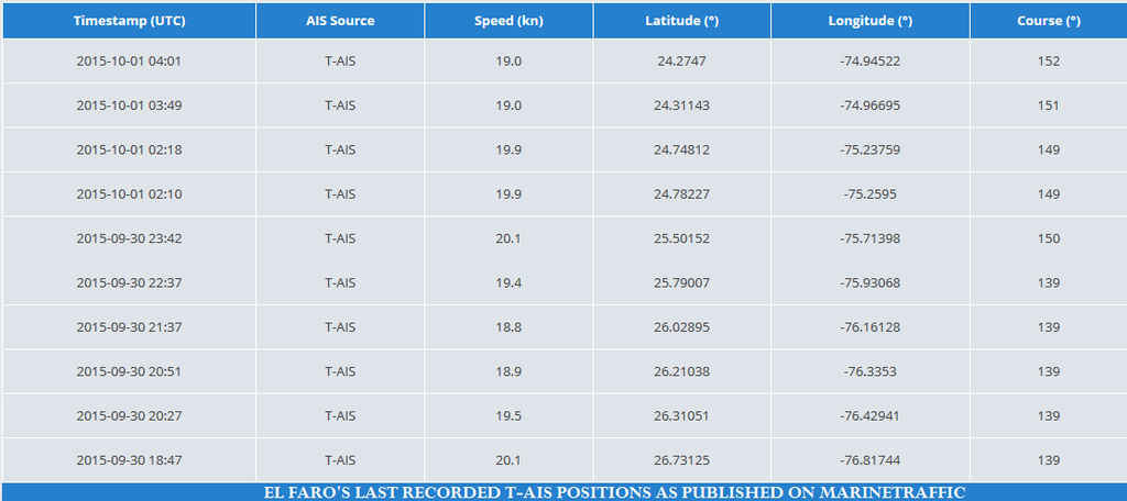
I’ll just post the final T-AIS positions that I see from El Faro, for the record:
 [/QUOTE]
Fantastic work, I am working on creating a massive timeline of the El Faro from the moment it left port to the last known location, including customs maps created by myself. I am a “Map guy”.  If you would like to collaborate, PM me.
-
-
- Updated - - -
-
[QUOTE=Phil O’Connell;170805]"NTSB vice chairman Bella Dinh-Zarr she said remotely operated vehicles would be used to retrieve the ship’s voyage data recorder, which will be critical in discovering what happened and could be as deep as 15,000 feet.
The ship’s “black box” is designed to begin emitting a signal as soon as it’s submerged in water. The beacon will last about about 30 days — the lifespan of its battery. "
from:
http://www.nbcnews.com/news/us-news/missing-el-faro-search-crew-members-be-called-n440271[/QUOTE]
This is the MOST importnt passage from the news story you posted:
" Anthony Chiarello, president & CEO of TOTE, Inc., the company that owns the ship, told reporters Wednesday that the company is doing all it can to support the families of those feared lost. “Our number one focus has been, and will remain, the family, the loved ones and friends of those on board the vessel,” he said. "
I am trying to keep the focus on the crew, not the ship as much as I can. I am deeply saddened by their loss and have been bothered by this story from the moment it broke. I have lost two brothers to the sea myself, so I know the pain the families are going though.