[QUOTE=z-drive;163394]Paddy, you will listen to the weather and say wtf? My trick when I had to use it is to know what area I’m in so I know what info to take note of. Pencil and paper for sure. They tend to break it down to lat/lon areas that can be confusing. I preferred a weather fax. Sometime I want to re-activate and test too.
NMN should be on at 0430 eastern time I think?
Anyone on the east coast wants to try one of these days, let me know. Hopefully I can get the thing to work.
ALSO, I know the furunos can be unlocked or hacked so you can put in whatever rx/tx frequency you want. Italian draggermen used to use the last 4 of their phone number.[/QUOTE]
The mates should all know how to use the SSB, in fact PSC sometime asks the mates to demonstrate that they can use it. It would also be good be aware of and be in practice receiving weather by that method.
However getting wx by voice is not very convenient for daily use. The three main sources for weather info for me are first, the twice a day email updates for the weather progam that runs on computers in my office and on the bridge. Secondly is the weather from the Inmarsat C EGC. Thirdly is the wx fax.
The weather program on the computer is by far the easiest way to understand the overall situation as well as what I can expect to encounter. I can click ahead in 6 hr increments and watch the fronts, pressure systems, sea and swell height and direction plus currents and sea temps. The program automatically adjusts the ships SOA according to the conditions. It’s surprisingly accurate, most of the time.
I also have the most current available text forecast posted in the wheelhouse. I (try to) have the mates mark the salient information rather then just rip it off the printer and hang it up. It’s much quicker to mark them up if you know the area as you say. I use BA pubs so I go into the Admiralty List of Radio Signals and find the page with the map of the area we are in. I copy the map and post that alongside the WX text. The ones we use often are laminated and kept in a folder.
Here are the areas Z-Drive mentions.
The high-sea areas.
Handy to have while listening to the voice broadcast.
Here is the offshore areas:

Inshore:
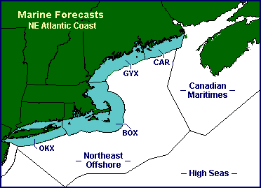
Marine (CAR) Eastport, ME to Stonington, ME out to 25 miles
Marine (GYX) Stonington, ME to the Merrimack River, MA out to 25 miles including Casco Bay and Penobscot Bay
Marine (BOX) Merrimack River, MA to Watch Hill, RI out to 25 miles including Boston Harbor, Cape Cod Bay, Nantucket Sound, Vineyard Sound, Buzzards Bay, Rhode Island Sound, Block Island Sound and Narragansett Bay
Marine (OKX) Montauk Point, NY to Sandy Hook, NJ out to 20 miles including Long Island Sound, Long Island Bays and NY Harbor
I have this stuff all posted for whatever area we are in.

