Judging by the fairly parallel run of the boottopping, one might assume that she would not be too far away from 11m aft. I have not heard any figures apart from the for’d draft. Judging by another photo taken from aft along the starboard side she appears to be hogged. Bit of a stab in the dark sorry.
1 Like
Indeed.
The figures are a little overwhelming. Even if they stripped 4000 empties off her at 4t/ FEU, they still have a great deal of mud to shift. They effectively need to dredge a 6 metre channel from the bottom baseline back towards the Craighill channel. Their best bet may be to dredge along the partially displaced grounding track and drag her out stern first.
They are schooner rigged with dredging infrastructure and this task will take time.
It would be interesting to view a multi beam echo sounding of the grounding track.
1 Like
Significant squat at that speed and by the bow which would have had some effect on steerage. From departure Baltimore channel speed had been 7~8 knots and just prior to Craighill Angle was bumped up to 12 knots with the associated increase in squat.
One would like to believe that GA will be limited to salvage costs and be a far cry from the outright extortion which took place with the Ever Given.
2 Likes
I am tempted to go out and see if I can find the trench they dug in the mud. Sooner or later someone with Navionics Sonarchart* will go out there and upload the data and it will be visible to all. I am betting once that ship is hauled out of there that trench will become a place to fish.
- If you have that feature turned on, your plotter will record the depths as you go and upload the data to Navionics.
She is presently indicating 11m forward so one could reasonably assume, from pre grounding soundings, that she is buried in the order of 3~4 metres. That may prove to be a significant grounding track trench……and a future fishing hole.
2 Likes
You have had a very fortunate career!
1 Like
Agreed. If you look at the AIS replay the speed rapidly increased from 9.5 knots in a channel depth of 14.6m to 12.4 knots midway through Craighill Angle in 15.1m of channel depth. The final speed, just prior to grounding, was 13 knots. Therefore the vessel was accelerating.
2 Likes
thanks you, yes.
I can’t really imagine what that channel looks like from the bridge of a VLCS.
But this…

What’s the reason for not have already having completed (or mostly completed) the turn at that point? Was there meeting traffic or some other reason?
Neither loss of steering nor helmsman error fully explain that.
2 Likes
Here’s a video bigger scale. Evidently the ship was turning before the end of the wider part of the channel.
Link to video is here.
3 Likes
Looking at that, I don’t have a clue what happened on that ship.
I don’t know, he lost me 30 seconds in when he says “fun fact” that the tugboats are named after somebody important in the Captians life.
4 Likes
Hi Everybody, I’ve been lurking for a while. The 75% waterplane area woke up old memories.
I was wondering what the tons per inch (cm) immersion figure would be. Check me if I’m wrong please. This is easier in metric until the end
334m x 84m x 0.75 = 28056 metric tons per meter immersion.
Beginning draft 13m, ending draft 11m so 28056 x 2m = 42084 mt grounding force
42084 mt x 0.3 friction coefficient for mud (from Navy salvage manual) x 1.12 to correct to short tons = 14140 tons bollard pull to get her off.
I miss something or is this something like 100 large salvage tugs?
Ross
1 Like
Hello Ross and welcome,
She has a 48m beam and you need a multiplier of 1.025 for salt water. A rough calculation using the same block coefficient would indicate a TPC of around 130 tonnes.
She will have to float out of her grounded position requiring a significant amount of dredging. The larger of the two clam buckets is currently off station undergoing maintenance alongside at Baltimore.
Happy to be corrected.
2 Likes
Ausmariner,
You are right and I stand corrected, perhaps that’s why I don’t drive ships anymore. Here it is recalculated:
334m x 48m x 0.75 = 12024 metric tons per meter immersion.
Beginning draft 13m, ending draft 11m so 28056 x 2m = 24048 mt grounding force
24048 mt x 0.3 friction coefficient for mud (from Navy salvage manual) x 1.12 to correct to short tons = 8080 tons bollard pull to get her off. That is a huge difference.
I ignored a correction for salt water because the upper Chesapeake is brackish and the salinity varies by the hour. It probably isn’t even figured into the calculations of the salvors because it is so unpredictable.
Still very big but probably doable. I wonder if they are going to need to put salvage anchors across the channel to help pull?
I grew up on the Chesapeake so I have lots of experience going aground and I can tell you, it is all muck.
Ross
4 Likes
Some questions and observations:
Is the 11.0 m. draft Mean draft or only Fwrd.?
Is she sitting on a flat or sloping bottom?
If the last the bottom reaction would not be uniform of the entire bottom area.
Does the bottom consist of soft silty mud?
If so is it overlaying sticky clay and at what depth below mudline?
I would assume that the Salvage Master has already asked these same questions and had both a side scan sonar survey, bathymetric survey + bottom sampling carried out all around the hull.
An analysis of the soil samples plus calculation of bottom reaction force will enable him to judge what is the best approach for the salvage operation.
PS> Bucket dredgers doesn’t remove mud from under the hull of the casualty.
Are there any jet/water injection dredgers available in the area?:
1 Like
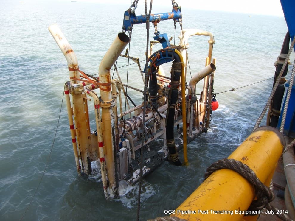
Reminds me of the burial sled that was used in the North Sea on the Forties Field pipeline.
I have photos of the thing someplace and will post them if I can find them. It looks something like the photo below. it was powered by 4 gas turbines, 2 for air compressor drive and 2 for water pumps and could dig a hole big enough to bury the entire ship in a day or two.
2 Likes
You can’t see under water by looking out the window. Pilot’s knowledge of the underwater and Captain’s knowledge of the ship, handling response and cargo load distribution combine to determine action.
True!!
But you can see the buoys and maybe some landmarks.
Or other indications of danger, like other vessels, or WAFIs in the fairway.
You are right about that! Another is the interaction between fore and aft draft,
and sail area vs wind speed and direction. An LST which had almost no draft at the bow could not turn into strong wind on the port side. It did a 270 turn downwind instead.
Advance planning helps but it isn’t always the answer.