[QUOTE=AHTS Master;60982]This may be true but I think the Master got a little too close to the rocks.[/QUOTE]
Well, you just won the understatement award.
[QUOTE=AHTS Master;60982]This may be true but I think the Master got a little too close to the rocks.[/QUOTE]
Well, you just won the understatement award.
[QUOTE=AHTS Master;60982]This may be true but I think the Master got a little too close to the rocks.[/QUOTE]
AHTS Master, no shit !!
But was there another reason?
[QUOTE=Steamer;60984]Well, you just won the understatement award.[/QUOTE]
No shit, Steamer !!!
“threw”. You really have a fucking third mate unlimited tonnage oceans license and you don’t know the difference between “through” and “threw”, wow, God help us all! Maybe you should go work on a cruise ship, you seem to be a smart as the rest of the crew!!!
New3M, take at look at post 27.
[QUOTE=AHTS Master;60982]This may be true but I think the Master got a little too close to the rocks.[/QUOTE]
As Japanese pilot once said to me when I asked about depth of water outside a channel… ‘plenty of water over there Captain; just not so deep’…
[QUOTE=deepdraft;60989]As Japanese pilot once said to me when I asked about depth of water outside a channel… ‘plenty of water over there Captain; just not so deep’…:D[/QUOTE]
Howdy deepdraft, I’m a pilot (no, not ship, the other kind) and was instructed early in my navy years that the altitude above me doesn’t mean shit. What this has to do with this thread I haven’t a fooken clue.
Good night
[QUOTE=Sweat-n-Grease;60990]Howdy deepdraft, I’m a pilot (no, not ship, the other kind) and was instructed early in my navy years that the altitude above me doesn’t mean shit. What this has to do with this thread I haven’t a fooken clue.
Good night[/QUOTE] Just tying to interject a bit of levity… hey Sweat-n-Grease you know the 4 rules of piloting a ship don’t ya?? It’s all pretty simple really… so simple I’m sure even an engineer can come up with the right answer. 
It’s nice to see that you guys agree with me.
We have good water all the way to the rocks Captain!!
[QUOTE=Sweat-n-Grease;60983]Actually, the truth is now known. It will be sealed as jurisprudence takes its timely course.
Are you posting that such ships on such mission are such a joke that no rules apply?
I watched tonight’s news, the Captain seemed far from remorseful.
Mistakes were made.[/QUOTE]
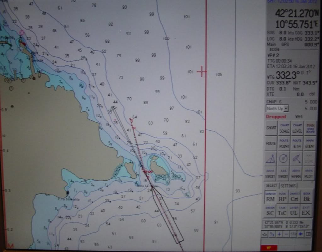
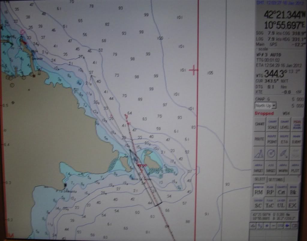
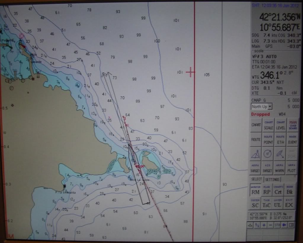
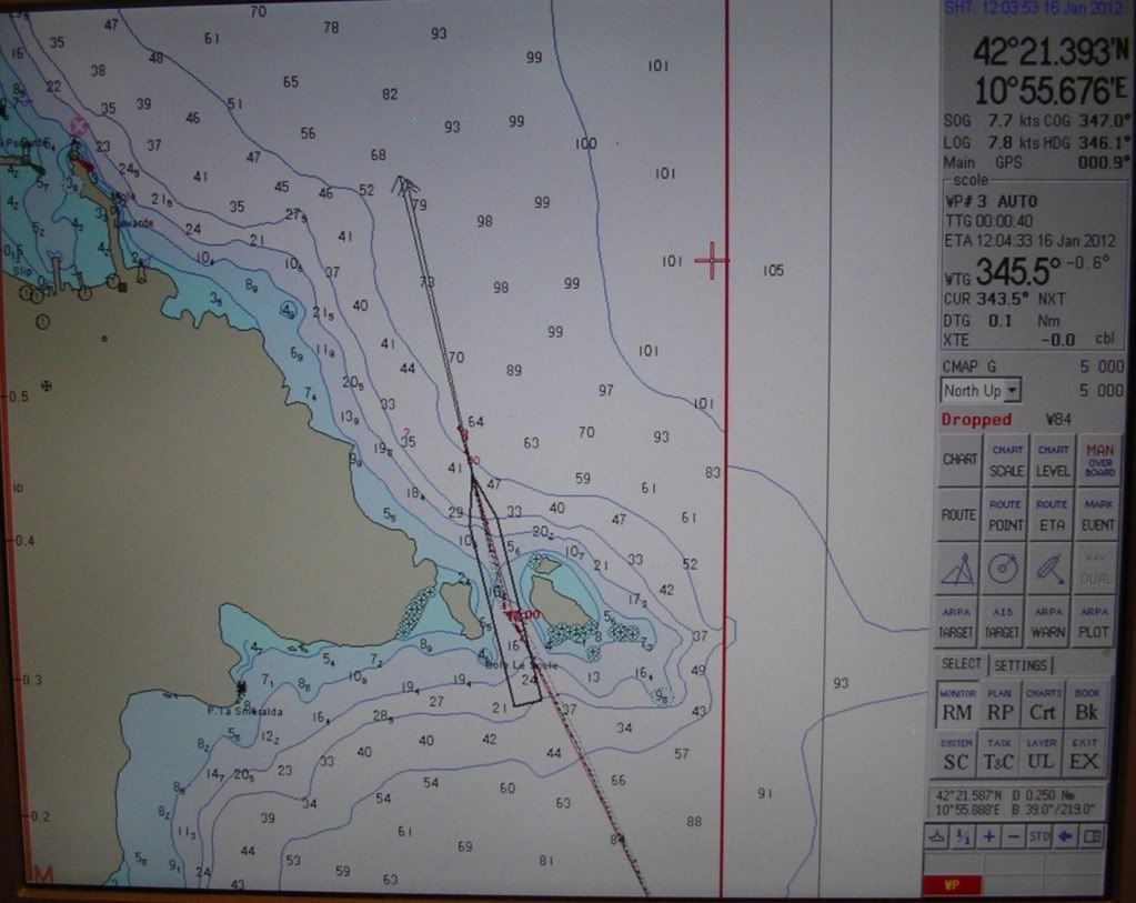
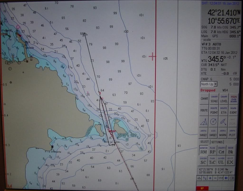
Yes, I understand mistakes were made, and yes, I understand that the Master is always responsible for his ship etc. etc. But the truth is not known. If the voyage plan is as the picture below shows (taken from this very website), and they finally found a rock, then it is obvious where the blame lies. Personally, I find it hard to believe that that was the intended voyage plan. But it looks like the VDR has been retrieved.
And no, I’m not saying that such ships on such mission are such a joke that no rules apply. I’m saying the opposite. There SHOULD have been a boat drill upon departure, like the rest of us do when the situation requires it. But even when there is a boat drill, you know just as well as I do that the common cruiser will not remember where they are supposed to go or what they are supposed to do, and it will look exactly as it did in the video that we’re seeing.
captmarcus, I welcome any grammatical commentary.
[ATTACH]1502[/ATTACH]
[ATTACH]1503[/ATTACH]
[QUOTE=deepdraft;60992]Just tying to interject a bit of levity…[/QUOTE]
and to think I saw your post as “War and Peace” …
of course, I saw the fun you rendered, and I like it.
[QUOTE=deepdraft;60992]hey Sweat-n-Grease you know the 4 rules of piloting a ship don’t ya??[/QUOTE]
Actually deepdraft, at this time of night I consider myself fortunate to know anything at’all. I can mention the 4 rules of flying, if I try hard enuf.
[QUOTE=deepdraft;60992]It’s all pretty simple really… so simple I’m sure even an engineer can come up with the right answer. :)[/QUOTE]
Now … Now
deepdraft, don’t get all Decky on me. :o
[QUOTE=New3M;60996]Yes, I understand mistakes were made, and yes, I understand that the Master is always responsible for his ship etc. etc. But the truth is not known. If the voyage plan is as the picture below shows (taken from this very website), and they finally found a rock, then it is obvious where the blame lies. Personally, I find it hard to believe that that was the intended voyage plan. But it looks like the VDR has been retrieved.
And no, I’m not saying that such ships on such mission are such a joke that no rules apply. I’m saying the opposite. There SHOULD have been a boat drill upon departure, like the rest of us do when the situation requires it. But even when there is a boat drill, you know just as well as I do that the common cruiser will not remember where they are supposed to go or what they are supposed to do, and it will look exactly as it did in the video that we’re seeing.
captmarcus, I welcome any grammatical commentary.
[ATTACH]1502[/ATTACH]
[ATTACH]1503[/ATTACH][/QUOTE]
Good reply
Uh, that’s insane.
It’s fairly clear in the Captains own words.
The ship was a mere 150 yards (meters) from shore at the time of the grounding, ANSA quoted Grosseto prosecutor Francesco Verusio as saying.
Captain Schettino insisted he was twice as far out and said the ship ran aground because the rocks weren’t marked on his nautical charts.
However, he did concede he was maneuvering the ship in “touristic navigation” — implying a route that was a deviation from the norm and designed to entertain the tourists.
“We were navigating approximately 300 meters (yards) from the rocks,” he told Mediaset television. "There shouldn’t have been such a rock. On the nautical chart it indicated that there was water deep below."
Costa captains have occasionally steered the ship near port and sounded the siren in a special salute, Arienti said. Such a nautical “fly-by” was staged last August, prompting the town’s mayor to send a note of thanks to the commander for the treat it provided tourists who flock to the island, local news portal GiglioNews.it reported.
But Arienti and other residents said even on those occasions, the cruise ship always stayed far offshore, well beyond the reach of the “Le Scole” reefs.
“Every so often they would do a greeting, but not so close — far away, safely,” said resident Giacomo Dannipale.
Residents of Giglio said they had never seen the Costa come so close to the dangerous “Le Scole” reef area.
“This was too close, too close,” said Italo Arienti, a 54-year-old sailor who has worked on the Maregiglio ferry between Giglio and the mainland for more than a decade. Pointing to a nautical map, he drew his finger along the path the ship usually takes and the jarring one close to shore that it followed Friday.
[QUOTE=Observer;61009]These photos of an AIS or ECDIS screen have emerged on several forums without any attribution:
Does anyone recognize the user interface as something from a live ECDIS as opposed to a training simulator? These do not look like Photoshop jobs but they could be faked through other means.[/QUOTE]
SIMULATOR but possibly using AIS data but it this AIS data at all accurate and where is it captured from? I for one believe that the ship did in fact “thread the needle” since her hull must be breached on both sides as she would have heeled to port if that was the only side opened up. She must be ripped open much more on her starboard side and there is only one way that both sides could have becomed opened up simultaneously. As already mentioned here, the ship continued through and past the town until it was clear she was doomed and then our illustrious master attempted to come about and quite possible hoped to get her smack into the mouth of that tiny harbor. WHAT WAS HE THINKING!?!
I will say this, if that is even close to an accurate representation of the size of the ship relative to the width of the passage we have a clear case of criminal negligence on the part of not just the master but all officers present on the bridge!
.
whatever he ^^ saids i agree with.
After looking at the charts and the photos I have one thing bothering me:
It looks to me like the Costa Concordia was on a southward course when she capsized. On the photos taken from the harbor, you can see the bridge very clearly in front. That would mean she did a U-turn after having scraped her bottom open squeezing through the Le Scole reef.
Markus
What did we expect, the CEO to admit such a “practice” was encouraged, just make sure it all comes out all right?