Like Your tree. Cool.
Cheers
Here’s Bowditch:
The complex challenge of clearly defining the limits of Earth’s polar regions is problematic, yielding diverse conclusions determined by the different desires of interested parties. Astronomically, the parallels of latitude…
Which definition one uses is going to depend on which one is useful for purpose. If the intent is to comply with the Polar Code than the definition in the code is the one to use.
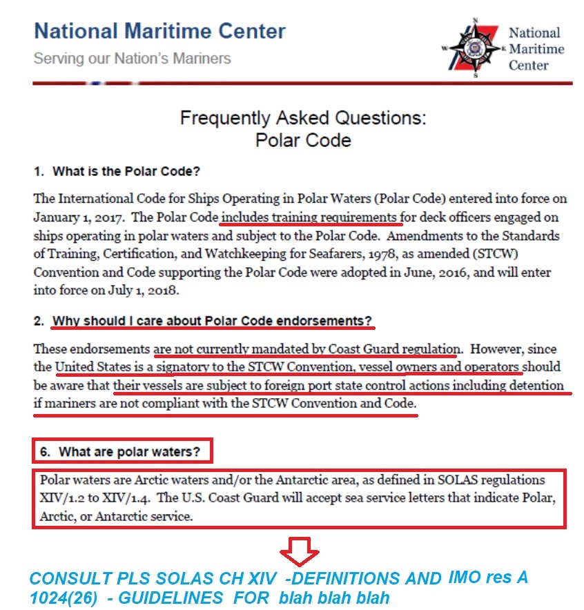
This is a link to the definition in the polar code.
Here’s a summary:
- The Arctic area, as defined in Regulation 46 of MARPOL Annex I, which generally refers to the area north of latitude 60°N, but excluding specific waters such as the Norwegian Sea and areas surrounding Iceland.
- The Antarctic area, as defined in MARPOL Annex I, which refers to the area south of latitude 60°S.
Looks to me we are drifting slowly into „”. HURRICANE v/s HURRICANE Force winds”” kind of debate which was polarised and eventually got frozen.
We ought to be able to navigate directly to our destination.
If someone says “Let’s get the meeting underway”, in that case the appropriate place to find the meaning of “underway” Is in a dictionary. When same term is used in the COLREGS the correct place to find the meaning is in the definition section of the COLREGS pub.
The same principle applies regardless of the subject.
THX for your words of encouragement .Let’s navigate to our destination . Here is my voyage plan to a destination called " DEFINITION " waiting for your kind approval .
EXHIBIT 1.
EXHIBIT 2.
EXHIBIT 3.
EXHIBIT 4.
EXHIBIT 5 which from my chair is seen as manipulation and mudding the waters.
Ok, perhaps Valdez in in polar waters with in the Polar Code, I don’t know absolutely for sure and don’t feel like plotting it out. The point stands that the meaning depends on the definition.
That said there is this:
The ports of Anchorage and Valdez, along with all other waters south and west of the Etolin Straight, are not within polar waters.
Both Valdez and Anchorage do however fit the general “north of 60 degrees” definition.
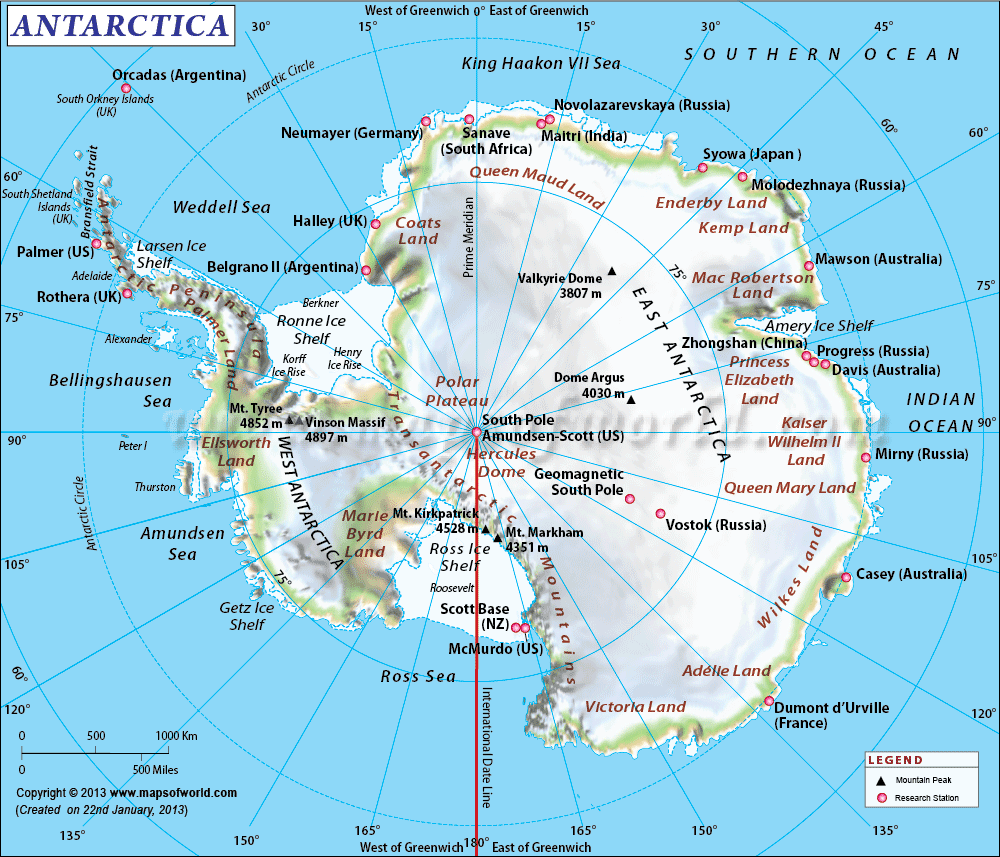
The Antarctic circle according to cartographers is shown as being 68 degrees South but compliance with SOLAS is required. To the uninitiated the ice seems a hell of a lot closer than the map says as you head south.
Are You @Kennebec_Captain serious then by providing link to Maritime Executive??
Out of respect to viewers and participants I have provided in post no.7 normative references to adequate sources , DNV, IMO, The Polar code itself .
In post No.25 references to USCG, Solas Ch XiV , Res A 26/1024
Defining the Polar waters required “precision” and finaly we both found the precise definition with Sir Bowditch watching from “above” .
And I have no problem with the contents of the linked article. No problem at all. But it is not a normative reference. It is an article in a news outlet.
Any chance for info from USCG or some other US Gov maritime institution .
Now assuming what is contained in the article is true : US flagged vessels are not required to comply with polar code when ingaged in cabotage in polar waters then there is not need for US personel to have any training . If so , then why USCG considered issuing the below document . What for???
2018 CG-MMC 02-18 Polar Policy (June 25.2018).pdf (747.5 KB)
Can You explain or may be @jdcavo can?
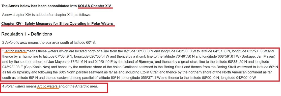
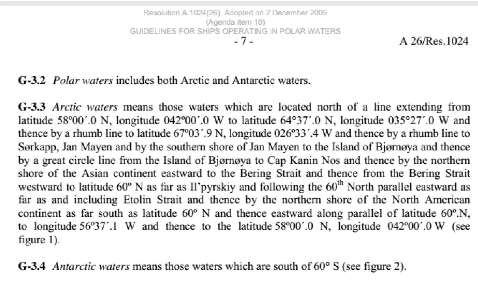
Looks like the boundary follows Lat 60° till Etolin Strait and then follows the northern shore.
following the 60th North parallel eastward as far as and including Etolin Strait and thence by the northern shore of the North American continent as far south as latitude 60º N and thence eastward along parallel of latitude 60º.
Here’s a map:
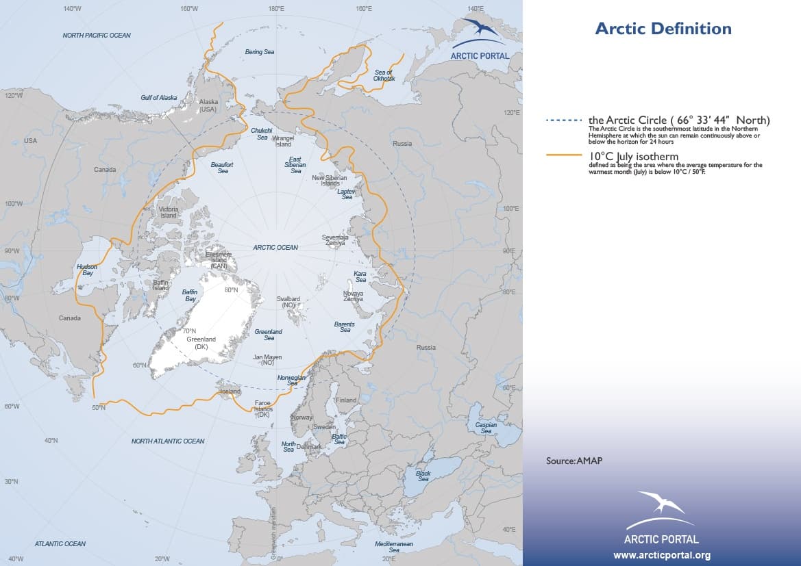
Here’s a map showing the 10° C temperature July isotherm compared to the Arctic circle. From here.
There are different definitions of the Arctic. The most widely used definition, the area north of the Arctic Circle, where the sun does not set on the June Solstice, is used in astronomical and some geographical contexts. However the two most widely used definitions in the context of climate are the area north of the northern tree line, and the area in which the average summer temperature is less than 10 °C (50 °F)
6 posts were split to a new topic: Polar Code does not include ports of Valdez or Anchorage
It’s true that some definitions require precision. In the regulatory domain an example is the polar code.
There are many example where such precision is not needed,
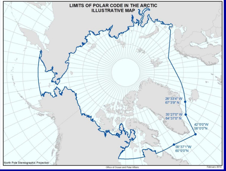
Thx for the pic that indicated the source Office of Ocean and Polar Affairs - United States Department of State
It looks however there are some sources that have a bit different interpretation of what You quoted from Solas Ch XIV
Pic below:
Acc to this pic all waters withing above pictured circular figure are waters where Polar Code does apply.
I do not care very much if waters south of Anchorage & Valdez to parallel 60N are exluded or not as I have zero interest in it .
My interest is in what You called precision. Hence I find Your interpretation as to say the least vague as You pick a sentence out of context and and navigate happily forward.
Quoted from The Maritime executive fragment in my post 29 I found original as it does not indicate the official source validating such claim and I do not care whether it is valid or not.
So lets explore/navigate your quoted text above again.
" looks like the boundary follows Lat 60 till Etoin Straits "
I have no problem with that.
Then : " and then follows the northen shore "
Well I have a problem with that as all here surely know, that from Etolin str it must follow first the western shore in northerly direction - but i may be wrong with my precision.
So lets look at your quote of the original text :
" following the 60th parallel eastward as far and including Etolin str and…" - i think in this we are still together.
" … and then by northern shore of the North American continent …" I do not know . May be i missed something as from Etolin str to Northern shore there is a helluva distance . Did i miss teleportation?? or what ?? I thik that is the position where we split You went north and I have figured to go south .
Then:" …as far south as lattitude 60N …"
So i am at lat 60 N . So how far south shall I go from here to to get to "…as far south as lat 60N " for God’s sake??? Two steps , 5 feet, 69 meters may be??? I do not know what to do . You went north and i am jaleous as I want to go somewhere too.
Then :
" …and thence eastward allong parallel of latitude 60N. "
So i fugured ,that is the path I will follow remembering to keep lovely city of Anchorage and Valdez on my port side while heading east allong parallel 60N.
May be your interpretation is good - i do not know but pls explain how in the process of " following the northen shore " You ignored the proposed voyage plan to go " as far south as Lat 60 N and then eastward along parallel of latitude 60 "
May be You corrected the plan and turned back south .But if so be so kind to say at which point.
Your map is nice, it is from gov. source but blowing it does not reveal required details.
Cheers
The use of the term “thence” is similar to the metes and bounds method used on old deeds here in New England.
If the boundary continued along the 60 degree line at Etolin Strait that point wouldn’t be mentioned.
Both maps are equally precise, only one is accurate.
Thx .That was an ellegant way of saying that " i am struggling with english " ![]() and i have no problem admitting it and accept it as an interesting lesson.
and i have no problem admitting it and accept it as an interesting lesson.
Thought 2009 deed is a new deed not old .
Lets leave it at that w/o further discovery .
As far as i am concerned this thread has given me some very interesting added value.
In the 80s I was a devout listener of VOA in special english and there was a program " Words and their stories " reflecting on some meanings, words histories and american idioms and i remember this particular description of " cold" .
The programs were of course on HF radio , then they shifted to internet. I think it was in the late 90s when they shifted to internet and i somehow got into their database containing all previous programs in mp3 files and i downloaded the whole thing . I still keep it : issues in the news, jazz hour with Willis Conover, american caffe , and many other
here is one example:
spec0030aTHU.wma (4.4 MB)
You can not immagine how I was brainwashed by them at that time - effing pro-american fanatic ![]()
![]()
![]()
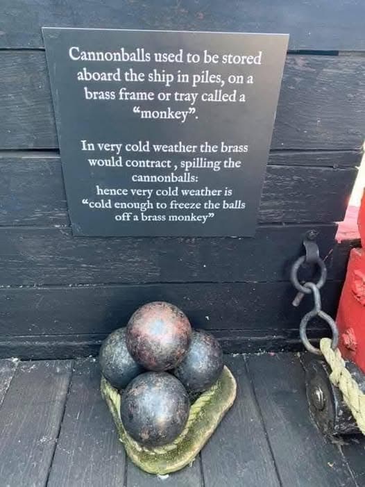
It passed into popular idiom as “Cold enough to freeze the balls off a billiard table.”
The metes and bounds method is still used today, just not exclusively as much as in the past.
In this case it makes sense, a list of bearing and ranges or waypoints for the entire northern shore of the North American continent would be very lengthy.