The difference between Bristol Bay and NE Greenland is the presence of large glaciers and icebergs.
The inland glaciers are pushing large amount of sand, silt, gravel and rocks as they move ahead, depositing it into the fjords. As the ice front resides this forms banks in the fjords.
Icebergs that calf off the glaciers drift through the fjords towards the open sea, frequently changing the bathymetric of the fjord bottom as they ground on sand and silt banks.
This is a process that has been going on for thousands of years and is how the fjords of Norway, Alaskan panhandle, BC, New Zealand and Southern Chile was formed.
Even if accurate depths are measured and charted one year, it will not be correct the next year.
Therefor the shallows are not as predictable as static banks and bars in rivers, whether in Alaska, or shifting banks in Indonesia, where I sailed on rivers in my younger days. (RoT; Keep on the outside in the bends)
An anecdote from NE Greenland; In the 1950s one of the seal catches from my home town had been on charter to supply methodological stations and eskimo settlements there. When they returned the owner was keen to know about the conditions there (meaning navigational and ice conditions)
The Skipper’s reply; “Well the moral there was at a low and comfortable level”.
My point is what characteristics they each share, in this case how of erosion and deposition by running water effects underwater depths.
On some rivers an astute observer can anticipate to some degree where the deep and shallow spots are by the shape of the bank.
I’m thinking that might be true to some degree with glacial deposits in fjords as well. For example there might be glacial deposits where one would expect to see an alluvial fan.
Someone taught me a common-sense rule early on that the topography that can be seen is indicative of the shape and depths of the areas nearby that are under water. In general, low land onshore will yield to shallow depths while tall cliffs on the banks will yield to deep water. Another is that silt will build on the inside of turns on shallow rivers; anyone plying their trade in shallow rivers or the intracoastal is familiar with this one.
They share characteristics but large icebergs dredge up surprisingly large humps of silt and sand.
A similar phenomenon is when a barge is pushed through and dredges up a hump where there was water previously.
The easiest way to deal with operating in this sort of environment is to carry extra ballast that can be pumped off in a hurry, enough to raise the draft around 3-4". If you don’t dilly dally in getting it off you’ll be fine.
In rivers you can anticipate where the shallows are, even when they move with after flood and build after droughts, but when the shoreline look like this it is hard to know where the shallows are:
As I said; the glacial front push a mound of silt, sand and gravel in front of it. When the front move back it leaves the mound behind, but iceberg that calf from the glacier front push their way towards the sea, thus nothing is statical on the seabed.
In fjords where there are no longer glacial fronts reaching sea level, thus no drifting icebergs such mounds are left behind, forming what is known as a “threshold fjord”:
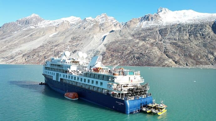
As can be seen the Ocean Explorer grounded quite far from shore:
Probably on such a “threshold mound”, which could have been reshaped by silting and drifting icebergs many times since last detailed bathymetric survey was carried out (if ever).
The Aurora Explorer is designed, built and equipped according to Polar Code 6 and has operated in both Arctic and Antarctic waters since new.
(I don’t know whether that include a forward looking soner, or not)
Unless proven otherwise, I would assume that the Master and Navigators on the Aurora Explorer were qualified for their position and experienced in operating in arctic waters.
Can we just say; “Shit happen when you sail in waters like the fjords in NE Greenland”.
This applies to any ship and to anybody, no matter their nationality, or how qualified and experienced they may be.
Alluvial fans forms from silt carried by flowing water, not flowing ice.
That article says the ship ran around on the moraine of the glacier. Also mentions “prodeltas”.
On one TV news report one passenger said that the trawler that assisted was used to place an anchor which was used as to kedge off.
A “classic navigation error” on a ship with “the latest cutting-edge technology, sustainability and navigation capabilities”.
Edit: According to that article a similar incident occurred in 2014 to Ponant’s Soleal which grounded in a Siberian fjord. In that case the incident report recommended the company provide additional training to the crew.
“Alluvial fan” is a terrestrial feature, so not the correct term. A similar feature that occurs when sediment loads flow into standing water is called a “fan delta”. The leading edge of that fan delta is called a “prodelta” which is mentioned in the linked article in the precious post.
The prodelta consists of fine-grained sediment, the more coarser-grained sediment being found closer to the river mouth.
The fjords in NE Greenland is a “project under development”, not a static thing.
The glaciers carry sand, gravel and stones that is deposited into the fjords as they calf:
As the glacier front resides it leaves moraine banks behind in the fjords.
These moraine banks gets pushed around by icebergs that calf off later, until the glacier front no longer reach to the fjord, as is the case in the fjords of Norway, New Zealand and Southern Chile.
No major rivers flow into these fjords, but silt is part of what the glaciers deposit and the melt water that flows from the glaciers during the summer season.
It’s possible that crew had little idea what navigation in those areas entail. They may have loaded up the ECDIS plugged in an UKC (under keel clearance) of half a meter and figured they were good to go.
The charts are not the only source of information, the pubs are important as well. Here’s the Greenland Pilot from 2016.
They no longer recommend saws and explosives for larger vessels but still do for smaller ones.
This is wrt surveys, depths soundings etc.
The reliability of the charts depends primarily on the surveying. The older the survey that
forms the basis for the chart, the less reliable the chart, partly because the means of surveying have become more accurate over time, and partly because the seabed is subject to
change in many places. The closer the sounding lines are to each other, the more reliably the
depth conditions can be indicated on the chart. However, it should always be remembered
that even the most careful surveys do not rule out the possibility that there may be rocks and
shoals with shallower depths between the sounding lines.
One should therefore try to avoid crossing shoals and shoals with shallow water, even when
the chart shows that there is greater depth than the draught of the ship.
For the sake of clarity, the charts only indicate a larger or smaller portion of the measurements taken with soundings.
If the soundings are scattered and unevenly distributed, this is an indication that the survey
was carried out in less detail.
Locations that are completely devoid of soundings should be regarded as not being surveyed.
However, if the surrounding depths are large and uniform, it can be presumed that there is
deep water at these locations, but if the surrounding depths are shallow or it is otherwise
indicated on the chart that the waters contain reefs, banks or rocks, these places should be
avoided or only navigated with extreme caution.
Locations where there are isolated soundings that are shallower than the immediately surrounding depths should be avoided in all circumstances.
When there are only isolated soundings close to land, particularly near protruding rocky
points, one should not be misled into believing that there is no water shallower than indicated by the soundings, because such places have not been carefully surveyed. You should
maintain a suitable distance from these shores and, in particular, you should not round these
points too closely and remember that any coast must be considered foul, when it is not apparent from the charts and descriptions that it is clear.
It is of course possible, but it is also possible that the Master and Navigators had years of experience in polar navigation and had read the Greenland Pilot.
After all this was a ship built for such voyages and operated by Aurora, a company experienced with such expeditions.
I don’t understand why you insist on assuming that this was some kind of “fly by night” operation, with unqualified crews and operators??
I used to sell forward looking sonar. It works great to avoid relatively vertical obstacles, but it is pretty much useless for shallow gradually sloping mud. Not only is the return very poor to totally nonexistent, the geometry in shallow water means even if you did see the shallow area, you have about 2 seconds to stop.
If poking into a poorly or non charted area with a vessel that can’t get itself loose, I would send a launch with a depthfinder ahead of me to scout. YMMV
edit - if you get the Navionics app, you can run all over the fjord in your launch and chart it yourself (see sonar charts, they are crowd sourced, your chart might end up helping others too)
Now I’m thinking that for mariners an understanding of how depths change over time would likely not be useful unless it was combined with local knowledge. Local pilots for example would be aware of which areas are subject to change.
For mariners without local knowledge likely the effort wouldn’t be worth the gain. For one thing given the lack sufficient accuracy and resolution of the old charts to begin with, on top of trying to estimate 50 or 60 years of change it’s likely be very difficult or impossible to do with sufficient accuracy.
In he fjords of Greenland local knowledge may help, but since the bathymetric change from year to year it would not help to have access to on even last years survey.
It may be possible to guess where morene banks forms as the glaciers reside, but hard to know where icebergs have grounded and pushed sand, silt and gravel around, forming banks and scour marks in unpredictable places.
PS> I was wondering how the small boats from Sirius Patrol got there so fast:
Not making any specific assumptions, pointing out there’s a range of possibilities. Could be some other kind of navigation error or, as is sometimes the case, a combination of errors.
It was mentioned by @MAK on the recent thread about the loss of a F/V on an uncharted rock the company could be collecting it’s own hydrographic data.