Tropical Storm NICOLE Forecast Discussion

NICOLE RAPIDLY WEAKENS TO A TROPICAL STORM… …BARELY MOVING…BUT EXPECTED TO MOVE SLOWLY SOUTHWARD SOON…

[B]

Tropical Storm NICOLE Forecast Discussion[/B]

[HR][/HR][TABLE=“width: 100%”]

Home Public Adv Fcst Adv Discussion Wind Probs Graphics Archive [HR][/HR]

[/TABLE]

000
WTNT45 KNHC 071436
TCDAT5

TROPICAL STORM NICOLE DISCUSSION NUMBER 14
NWS NATIONAL HURRICANE CENTER MIAMI FL AL152016
1100 AM AST FRI OCT 07 2016

Strong shear has taken its toll on Nicole overnight. The cyclone’s
cloud pattern has rapidly deteriorated, with the low-level center
now exposed to the northwest of a greatly reduced area of deep
convection. Dvorak Final T-numbers have decreased quickly to T3.5
from SAB and TAFB, and a blend of these and CI-numbers was used to
set the initial intensity to 65 kt at 1200 UTC. Since the cloud
pattern has degraded even further since that time, the advisory
intensity is lowered to 60 kt, which could prove to be generous.

Nicole has barely been moving, and the initial motion estimate
is nearly stationary. Although Nicole remains in a region of weak
steering at the moment, a blocking mid-level high should build
north of the cyclone soon, and impart a slow motion generally
toward the south for the next couple of days. Around 48 hours, a
mid-level ridge is forecast to develop to the east of Nicole, which
should result in the cyclone gradually turning northward with
some increase in forward speed through the remainder of the
forecast period. Most of the model guidance is in better agreement
than yesterday on this scenario, which increases the overall
confidence of the track forecast. The new track forecast is based
on a consensus of the regional and global models minus the GFDL.

A potent mid- to upper-level shortwave trough digging to the east
of Nicole should cause deep-layer northerly shear over the cyclone
to increase further today. In the wake of the shortwave, the shear
should veer to the north-northeast but remain just as strong
through about 72 hours. Nicole is also shown interacting with a lobe
of vorticity that fractures from the shortwave, but it remains
unclear how this interaction would affect the cyclone’s intensity or
structure. Regardless, the overall hostile environment should cause
weakening, perhaps even more than indicated in this forecast.
Indications are that late in the forecast period the large- scale
environment should become more conducive for Nicole to re-intensify,
but to what extent is in doubt. As a result of developments
overnight, the new intensity forecast is substantially lower than
the previous one and is below all of the intensity guidance through
72 hours. It is near the multi-model consensus after that time,
although this part of the forecast is of low confidence.

FORECAST POSITIONS AND MAX WINDS

INIT 07/1500Z 27.5N 65.3W 60 KT 70 MPH
12H 08/0000Z 27.0N 65.1W 50 KT 60 MPH
24H 08/1200Z 26.1N 64.8W 45 KT 50 MPH
36H 09/0000Z 25.4N 64.7W 40 KT 45 MPH
48H 09/1200Z 25.3N 65.1W 40 KT 45 MPH
72H 10/1200Z 26.6N 65.7W 35 KT 40 MPH
96H 11/1200Z 28.8N 66.1W 40 KT 45 MPH
120H 12/1200Z 32.0N 65.6W 50 KT 60 MPH

$$
Forecaster

Nicole 540 miles north of SJU - wind shear knocked it out of shape, in a region of weak steering

1 degree of Latitude = 60 NMi

Tropical Storm NICOLE Forecast Advisory

Home Public Adv Fcst Adv Discussion Wind Probs Graphics Archive

000
WTNT25 KNHC 090847
TCMAT5

TROPICAL STORM NICOLE FORECAST/ADVISORY NUMBER 21
NWS NATIONAL HURRICANE CENTER MIAMI FL AL152016
0900 UTC SUN OCT 09 2016

THERE ARE NO COASTAL WATCHES OR WARNINGS IN EFFECT.

TROPICAL STORM CENTER LOCATED NEAR 24.3N 65.7W AT 09/0900Z
POSITION ACCURATE WITHIN 25 NM

PRESENT MOVEMENT TOWARD THE NORTH OR 360 DEGREES AT 0 KT

ESTIMATED MINIMUM CENTRAL PRESSURE 999 MB
MAX SUSTAINED WINDS 45 KT WITH GUSTS TO 55 KT.
34 KT… 60NE 100SE 60SW 50NW.
12 FT SEAS…120NE 90SE 30SW 90NW.
WINDS AND SEAS VARY GREATLY IN EACH QUADRANT. RADII IN NAUTICAL
MILES ARE THE LARGEST RADII EXPECTED ANYWHERE IN THAT QUADRANT.

REPEAT…CENTER LOCATED NEAR 24.3N 65.7W AT 09/0900Z
AT 09/0600Z CENTER WAS LOCATED NEAR 24.3N 65.7W

FORECAST VALID 09/1800Z 24.3N 65.6W
MAX WIND 45 KT…GUSTS 55 KT.
34 KT… 70NE 110SE 60SW 50NW.

FORECAST VALID 10/0600Z 24.9N 65.5W
MAX WIND 45 KT…GUSTS 55 KT.
34 KT… 80NE 110SE 60SW 50NW.

FORECAST VALID 10/1800Z 25.9N 65.4W
MAX WIND 45 KT…GUSTS 55 KT.
34 KT… 90NE 110SE 60SW 50NW.

FORECAST VALID 11/0600Z 26.9N 65.5W
MAX WIND 50 KT…GUSTS 60 KT.
50 KT… 40NE 30SE 0SW 0NW.
34 KT… 90NE 110SE 70SW 70NW.

FORECAST VALID 12/0600Z 28.4N 66.3W
MAX WIND 55 KT…GUSTS 65 KT.
50 KT… 40NE 30SE 30SW 30NW.
34 KT…100NE 110SE 80SW 90NW.

EXTENDED OUTLOOK. NOTE…ERRORS FOR TRACK HAVE AVERAGED NEAR 150 NM
ON DAY 4 AND 200 NM ON DAY 5…AND FOR INTENSITY NEAR 15 KT EACH DAY

OUTLOOK VALID 13/0600Z 31.0N 65.5W
MAX WIND 60 KT…GUSTS 75 KT.

OUTLOOK VALID 14/0600Z 35.0N 60.5W
MAX WIND 65 KT…GUSTS 80 KT.

REQUEST FOR 3 HOURLY SHIP REPORTS WITHIN 300 MILES OF 24.3N 65.7W

NEXT ADVISORY AT 09/1500Z

FORECASTER BERG

Coming through the Turks and Caicos right now going trans-Atlantic. 6-8’ ground swells but otherwise stunningly beautiful weather down here.

Ya mean there was another storm in the Atlantic this week? How can that be? The weather channel never reported another disturbance.

I mean, the channel had a reporter standing along the Atlantic shoreline every fifty feet with one leg in the water, from Key West to Canada reporting on Matthew, and every leaf that fell off a tree was reported and videotaped ‘ad nauseam’ as being a great catastrophe very harmful to 12.5 million humans or whatever.

No reports on the cyclone that hit South Korea. No reports on any weather 50 miles WEST of the Atlantic coastline!

I think the weather channel needs a new management team. One that realizes there IS other weather to report on beside hurricanes and tornadoes in other states besides the Southeast and that some millions of people would be interested in.

Surfer Joe - I’m sure you know why.

Who pays for the weather channel? Advertisers.

Who buys advertisers stuff? Affluent Americans.

Who was glued to the weather channel for a week? Millions of affluent east coast Americans.

(it’s a profit deal)

//youtu.be/fKBRtdp2e98

[QUOTE=surfer-joe;191277]Ya mean there was another storm in the Atlantic this week? How can that be? The weather channel never reported another disturbance.

I mean, the channel had a reporter standing along the Atlantic shoreline every fifty feet with one leg in the water, from Key West to Canada reporting on Matthew, and every leaf that fell off a tree was reported and videotaped ‘ad nauseam’ as being a great catastrophe very harmful to 12.5 million humans or whatever.

No reports on the cyclone that hit South Korea. No reports on any weather 50 miles WEST of the Atlantic coastline!

I think the weather channel needs a new management team. One that realizes there IS other weather to report on beside hurricanes and tornadoes in other states besides the Southeast and that some millions of people would be interested in.[/QUOTE]

So you’re surprised the Weather Channel fixates on what generates money?!?
That’s why they’re in business.
It also irks me that the Weather Channel pretends there is no weather beyond the US land borders. As with Matthew, once it goes out to sea, it’s forgotten. Fuck the sailors.
I missed the coverage you are talking about as our power went out Saturday night when Matthew bitch slapped us and just came back on a few hours ago as the result of our community highjacking a power company bucket truck and gently rerouting it. There is still nothing but water as far as the eye can see. For whatever it’s worth, you’re right about the reporters being only present where the money is. None of them had the balls to report on the storm from our little island, although I can’t say I blame them as both their feet would have been under water.
As always, follow the money.

[QUOTE=Lee Shore;191346]So you’re surprised the Weather Channel fixates on what generates money?!?
That’s why they’re in business.
It also irks me that the Weather Channel pretends there is no weather beyond the US land borders. As with Matthew, once it goes out to sea, it’s forgotten. Fuck the sailors.
I missed the coverage you are talking about as our power went out Saturday night when Matthew bitch slapped us and just came back on a few hours ago as the result of our community highjacking a power company bucket truck and gently rerouting it. There is still nothing but water as far as the eye can see. For whatever it’s worth, you’re right about the reporters being only present where the money is. None of them had the balls to report on the storm from our little island, although I can’t say I blame them as both their feet would have been under water.
As always, follow the money.[/QUOTE]

Is it still called an island if it’s underwater? (welcome back)

[QUOTE=Lee Shore;191346]So you’re surprised the Weather Channel fixates on what generates money?!?
That’s why they’re in business.
It also irks me that the Weather Channel pretends there is no weather beyond the US land borders. As with Matthew, once it goes out to sea, it’s forgotten. Fuck the sailors.
I missed the coverage you are talking about as our power went out Saturday night when Matthew bitch slapped us and just came back on a few hours ago as the result of our community highjacking a power company bucket truck and gently rerouting it. There is still nothing but water as far as the eye can see. For whatever it’s worth, you’re right about the reporters being only present where the money is. None of them had the balls to report on the storm from our little island, although I can’t say I blame them as both their feet would have been under water.
As always, follow the money.[/QUOTE]

And did you have major flood damage Mr. Shore? How many inches in the crib? Insurance claim?

True, but the general public wants to see doom and gloom! As it has been pointed out, there is no money in reporting a beautiful day unless it is a big sporting event or a state fair!

I know Cantorie is not allowed down at Carolina or Kure Beach. Thats why he hangs out at Wrightsville now. Think Oak Island might have turned him down.
Got the report from the Missus that she didn’t have power for about 12 hours in the Surf City. area.

would you please just SHUT THE FUCK UP!

[QUOTE=Emrobu;191349]Is it still called an island if it’s underwater? (welcome back)[/QUOTE]

It is then called a reef.
We turn it into an awesome diving and snorkeling destination as sea life quickly begins to inhabit the infrastructure.
We apply to the EPA for a billion dollar grant to preserve the endangered species enjoying their new home and we use some of the money to establish a fleet of dive boats operating from the mainland.
We will thus provide employment for at least a few of the mariners who are thrown out of work when the cretinous anti Jones act dip shits finally get their way as well as those who suffer as a result of Ombugge’s obsessive schemes to automate everything that floats.

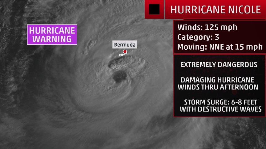
Hurricane Warning in Bermuda as Category 2 Nicole Approaches

Nicole gives Bermuda its fourth hurricane warning in three years
For being a small island in a big ocean, Bermuda has had an inordinate amount of bad luck with hurricanes over the past three years. Nicole is the fourth storm in the past three years to put the island under a Hurricane Warning. Last year, Hurricane Joaquin passed about 65 miles west-northwest of Bermuda on October 5 as a Category 2 storm. Joaquin brought sustained winds of tropical storm force to Bermuda, and caused power outages to 15,000 of the island’s 36,000 customers. Damage was minor, though.

Source Link: Weather Underground

By: Bob Henson and Jeff Masters , 5:02 PM GMT on October 12, 2016

https://www.wunderground.com/blog/JeffMasters/hurricane-warning-in-bermuda-as-category-2-nicole-approaches


Image source: weather.com

https://weather.com/storms/hurricane/news/hurricane-nicole-atlantic-bermuda

[QUOTE=Lee Shore;191381]It is then called a reef.
We turn it into an awesome diving and snorkeling destination as sea life quickly begins to inhabit the infrastructure.
We apply to the EPA for a billion dollar grant to preserve the endangered species enjoying their new home and we use some of the money to establish a fleet of dive boats operating from the mainland.
We will thus provide employment for at least a few of the mariners who are thrown out of work when the cretinous anti Jones act dip shits finally get their way as well as those who suffer as a result of Ombugge’s obsessive schemes to automate everything that floats.[/QUOTE]

And if your houses are still above water, you can turn them into dive-friendly, swim in, Air BNBs. Rent them flotillas of brightly coloured kayaks, Or just sit on your porch and get the tourists to do tricks for beer and ice cream. The dolphins are going to be entertained.

Only 55 miles SSW of the island!

This will be the strongest hurricane strike on Bermuda since Fabian in 2003

Only 12 other Category 3 hurricanes have passed near Bermuda since 1899

Source weather.com