El Faro - What was the Captain Thinking is the Wrong Question

[QUOTE=Dutchie;195747]I wonder whether there was a weather fax on board the El Faro, I cannot remember having seen any reference made to this equipment. For the Caribbean area regular weather faxes are scheduled by the National Hurricane Center’s Marine Radiofax Broadcast service via New Orleans, LA call sign NMG. These messages are updated frequently by also the data collected by dropsondes parachuted into the eye of the hurricane. That tricky job is done already since 1944 by the famous Hurricane Hunters.

These charts could be a very helpful means indeed to mariners in the case of hurricane navigation, especially since the number and intensity of tropical storms and hurricanes have increased considerably since the 80’s due to the warming of the earth. As a result tropical storms and hurricanes can nowadays also be found below the latitude of 15° north which was not the case in the old days.i[/QUOTE]

Don’t know if any of you guys have been back to the NTSB docket lately. I was going through engineering stuff there and noticed this report which might supplement what you guys seem to be piecing together.

Check this one out, but you will have to go up one level to see the attachments.

https://dms.ntsb.gov/pubdms/search/document.cfm?docID=447450&docketID=58116&mkey=92109

[QUOTE=Mat;195762]Weather History Graph for Crooked Island And Long Cay
September 30, 2015 - October 1, 2015

This graphic from the closest weather station to Sumana Cay illustrates how easy it would been to work out that they were going to get a direct hit. The weather station [ICROOKED2] was knocked off air shortly after the 129.4 km/h reading. The pressure was falling steadily since midday the previous day; wind speed steadily increasing; wind direction constant (no veering or backing). They were clearly in the direct path of the storm.
If El Faro had been able to see their own graphic for the same period it would surely have set off more alarm bells.[/QUOTE]

those graphs would be representative of multiple locations and a broad area.

The transcript clearly shows they were aware. They monitored relevant parameters and could not fail to see trend. If it didn’t ‘surely set off more alarm bells’, which appears the case, it is evidence that they just minimized the potential weather impact and hit the silence/acknowledge button.

This is the link for the first page of the docket documents.

https://dms.ntsb.gov/pubdms/search/hitlist.cfm?docketID=58116&CurrentPage=1&EndRow=15&StartRow=1&order=1&sort=0&TXTSEARCHT=

The weather stuff is at tab 14.

Thx KPChief.

Have you located the wind data yet?

"5.6.1.
El Faro Anemometer
El Faro’s VDR recorded wind observations from an anemometer located onboard the vessel.
Recorded parameters included ship -relative wind speed and ship -relative wind direction, which
were recorded with a frequency of about 15 samples -per-second during the 26 hours of
retrieved VDR data. [B] The anemometer data are available in the NTSB Electronic Data Factual
Report for the accident.[/B] "

[QUOTE=Mat;195767]Thx KPChief.

Have you located the wind data yet?

"5.6.1.
El Faro Anemometer
El Faro’s VDR recorded wind observations from an anemometer located onboard the vessel.
Recorded parameters included ship -relative wind speed and ship -relative wind direction, which
were recorded with a frequency of about 15 samples -per-second during the 26 hours of
retrieved VDR data. [B] The anemometer data are available in the NTSB Electronic Data Factual
Report for the accident.[/B] "[/QUOTE]

Try Tab 8 - Electronic data report and a bunch of attachments to that as well.

I’m thinking someone has to contact the NTSB to request a DVD? Anyone?:

“DCA16MM001
EL FARO
October 1, 2015
7
Electronic Data
Attachment 11 (VDR data) (XLSX)
[B]Contact the Records Management Division for copies of DVD[/B]
National Transportation Safety Board
Records Management Division
490 L’Enfant Plaza East, SW
Washington, DC 20594”

??? Hope I’m wrong.

[QUOTE=Mat;195769]I’m thinking someone has to contact the NTSB to request a DVD? Anyone?:

“DCA16MM001
EL FARO
October 1, 2015
7
Electronic Data
Attachment 11 (VDR data) (XLSX)
[B]Contact the Records Management Division for copies of DVD[/B]
National Transportation Safety Board
Records Management Division
490 L’Enfant Plaza East, SW
Washington, DC 20594”

??? Hope I’m wrong.[/QUOTE]

youre not. Legally, the data belongs to TOTE.

But in the electronic factual report they discuss:

											Anemometer Wind Data
				[I]El Faro [/I]was equipped with an anemometer that displayed wind data on the bridge, and winddata was recorded by the VDR.51 Throughout the VDR recording, over 99% of the anemometerdata samples indicate a relative wind direction between 180o and 193o. Transcribed VDR audiofrom the bridge indicates the crew questioned the accuracy of the indicated wind direction.
				"

Document 66 (tab 5)is the transcript of the recorded interview of the USCG rescue swimmer that went in to assess the floating survival suit. Even knowing they were called off to check on another sighting which could mean life or death, still disturbing to contemplate to have been that close to the deceased and have to leave them behind.

[QUOTE=KPChief;195764]Don’t know if any of you guys have been back to the NTSB docket lately. I was going through engineering stuff there and noticed this report which might supplement what you guys seem to be piecing together.

Check this one out, but you will have to go up one level to see the attachments.

https://dms.ntsb.gov/pubdms/search/document.cfm?docID=447450&docketID=58116&mkey=92109[/QUOTE]

That is one heck of a complete and impressive weather report about the weather situation! A enormous variety of weather information was available to the mariner out at sea, all for the taking. I am not yet finished reading it but the situation is already clear to me.

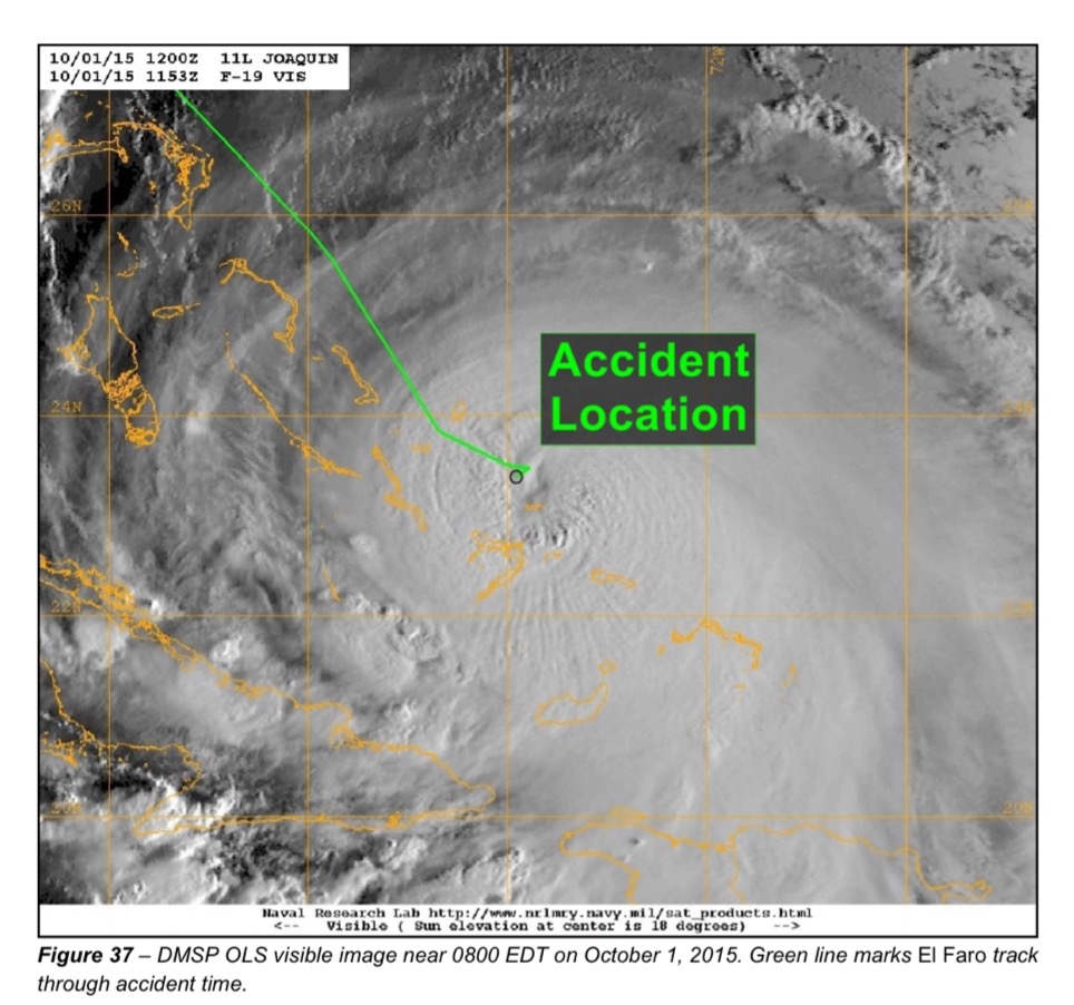
This is one of the dramatic pictures in the report that explains it all. I rest my case…

The UK’s Maritime & Coastguard Agency is unequivocal on this -if it is on board it must work or if above requirements repair it or remove it. I had an NC regarding a ‘company installed VDR’ in Dec 2015 following an Safety Management Certificate survey -it pissed me off as I had organised it to be removed but the surveyor got there first!

Also wrt how do you judge the wind speed without an anemometer? You use the mark one eye ball and a sea state chart which most UK vessels carry.

[QUOTE=Jamesbrown;195760]Didnt’ he?

Instead of your last, I would say, Had the Captain felt that the bridge watches’ ability to monitor wind direction and speed inadequate, he likely would have made more of an effort.

But he clearly felt that monitoring the weather was important as noted in his instructions of 30 Sep/1317:

Capt 13:17:04.8: From here-here out log the weather, just um wind direction and force, barometer every hou
Capt 13:17:14.3: Keep an eye on this I mean I know it’s in a lull

Capt 13:18:20.0: no, no, no, no I don’t necessarily need the temperature… the barometer

In terms of communicating uncertainty, I think he did, and certainly the 3M and 2M calls indicate they felt able to make observations on storm movement when they had info.

In any case, he did have them do hourly logs monitoring weather (wind speed force baro) and reviewed them and noted uncertainty in the storm action aloud. See 30 Sep/14:02 and after and note also his comment, “we’ll just have to watch it, there’s not much we can do (but they) the weather pattern itself is crazy erratic”.

With regard to an early comment of yours, KC, “almost seems”? How do you feel the transcript fails to support his minimization of weather impacts as a risk? I would consider his minimization of the threat posed by weather to anything but making way is key to his monitoring of the storm movement in less than line-by-line adherence to Bowditch recommendations.[/QUOTE]

Well first, my observations are not meant as criticism, I agree with freightman, practices to deal with heavy weather aboard ship evolve, ships that encounter bad weather frequently are more likely to use more effective procedures than ships that don’t. It’s possible a ship on the JAX/SJU run wouldn’t have a sophisticated way of dealing with the weather. That’s why I believe formal procedures should be in place.

As far as logging the weather observations hourly, this is standard practice, instructions are usually in the standing orders to record weather observations hourly at wind speeds at or over F-7, this is for the record to show charterers and so forth why the ship was delayed or cargo was damaged. This practice is mentioned in the book “Looking for a Ship” by McPhee.

How much weight the captain put on observations made by bridge I gauge by the fact the captain didn’t come to the bridge.

Also no written night orders - there should be written order with specific call points, for example if the forecast position does agree with expected.

CM
19:43:06.6
19:43:07.0
alright.
CAPT
19:43:07.2
19:43:09.0
just follow the rhumb line.
DCA16MM001
Voyage Data Recorder – Audio Transcript Factual Report
Page 232
Primary Communications Secondary and Electronic Communications
CM
19:43:09.0
19:43:09.8
got it.
CAPT
19:43:09.6
19:43:15.8
follow the rhumb line courses and steer to make good rhumb line
courses. (steer the) * * (route for) (weather/rudder).
CM
19:43:16.0
19:43:16.7
excellent.
CAPT
19:43:17.6
19:43:18.7

  • *.
    CAPT
    19:43:19.2
    19:43:20.5
    less is more.
    CAPT
    19:43:21.0
    19:43:25.6
    next thing you know you’re writin’ two or three pages on that and your
    interpretation(s) a little bit different.
    CM
    19:43:25.5
    19:43:29.9
    yeah but you already did it. you wrote that * * see what we got with the
    weather so.

“Throughout the VDR recording, over 99% of the anemometer data samples indicate a relative wind direction between 180º and 193º.”

No wonder the bridge questioned its accuracy - it would have been more likely 315º +

[QUOTE=Mat;195775]“Throughout the VDR recording, over 99% of the anemometer data samples indicate a relative wind direction between 180º and 193º.”

No wonder the bridge questioned its accuracy - it would have been more likely 315º +[/QUOTE]

This was mentioned at the hearing, one of the mates that worked there said it usually read 180 - the board members said that agreed with what they were seeing.

[QUOTE=Earl Boebert;195763]The situation with regard to assessing the location of the storm brings up the distinction between systems that are safety-critical and systems that are safety-relevant. A malfunction in a safety-critical system will generally directly lead to an accident (e.g., fly-by-wire control system.) A malfunction in a safety-relevant system will be a factor in an accident only if that malfunction misleads the operator into making the wrong decision. Safety-critical systems get a lot of attention, safety-relevant systems much less. The problem we seem to be having these days is that individuals are becoming so dependent on nominally “advisory” systems that those systems become, in effect, safety-critical.

The distinction was brought home to me many, many years ago when I was part of a team that developed a (ultimately unsuccessful) system for the DC-10 called Pafam. This thing used software to correlate various instruments and provide a display that showed the pilot his touchdown point in a low-visibility landing. Back then the FAA had no process for certifying software so the project was dead if the device was deemed flight-critical. Big meeting, FAA, NASA, chief pilot of Northwest Airlines, me in the back of the room with a stack of viewgraphs describing how we validated the software. Never got to present, because after an extended and somewhat heated discussion the FAA decided the device was only flight critical if the pilot believed it, and it was the duty of a command pilot to be skeptical of what the instruments were telling him. We seem to have drifted away from that attitude.

Earl[/QUOTE]

The thing about the weather software is they just gave it for us to use, they didn’t say be careful using this software because it can fool you into thinking there’s more precision in the forecasts than there really is. We had to figure it out on our own. If we were lucky we learned just by getting bounced around a bit more than expected a couple times.

Read post #6 by flyboy here

Document 55 of the docket is a very complete description of how TOTE loaded their ships at Jax.

With respect to this thread subject - within that transcript is the following exchange about weather program. (errata page shows that BBS should be BVS) The interesting part is the apparent freedom with which masters could select their routing, even to accommodate livestock. Does this square with the actual feeling of Masters though, I’m thinking of the section of the VDR voice transcript where the master was already lining up his ducks to take an alternate route north by informing the office but seemed hesitant to change route going south. (bold face added)

MR. KUCHARSKI: Okay, thank you, thank you.
Shifting gears a little bit now to weather related, are
you familiar with the BBS Applied Weapon Technology’s
program that the El Faro had?

MR. MATTHEWS: Yes, basically familiar. I’m
not deeply familiar with it, but I have seen it.

    MR. KUCHARSKI: Okay. Were you involved at

all with the load-up of that program on the ship or the
contracting to get that service?

MR. MATTHEWS: I am the one that actually,
when BBS – I forget the – Bill Howshour (phonetic) or
whatever, the sale guys, came through here. He showed
us what it was, and I recommended it to captains. This
goes back several years. I was involved somehow in the
process of recommending that people review it and, if
they decided they like it, to get it for the vessels.
For signing the actual contracts, I was not, but I was,
again, going back several years, I was somehow involved
in the process of seeing it and bringing it on board.

MR. KUCHARSKI: Okay. Do you know who
actually approved the contract?

MR. MATTHEWS: That is so long ago, to be
honest, no, I do not.

MR. KUCHARSKI: Okay. Did you have – so
you didn’t have access to the BBS system on shoreside?

MR. MATTHEWS: No, we don’t have that
shoreside. The actual BBS, this goes to the ships.

MR. KUCHARSKI: Okay, great. Do you
remember having any conversations with Captain Axelson
or any of the other masters about weather routing?

MR. MATTHEWS: I have had conversations with
the captains, and they actually, they liked the program
that they have. On occasion, they’ll tell me they’re
going down the Old Bahama Channel or maybe through the
Providence Channel after they have reviewed the weather
programs that they have. BBS is only one that I know
of that they use. I believe there’s a couple of others
out there. I think NOAA has one and underground
weather, something like that. They have several
sources, BBS being probably the most graphic that you
can understand, from what I have seen. But as far as
weather routing goes, they chose their own routes.
They decided that.

MR. KUCHARSKI: Okay. So you didn’t have
any specific conversations as far as adding weather
routing to the BBS suite?

MR. MATTHEWS: Oh, no, no, to the BBS suite,
their weather-routing option? No, no, not at all.

MR. KUCHARSKI: Okay, okay. Great, great.
And did you have any discussions with the masters
typically about weather expected on the voyage?

MR. MATTHEWS: Generally, whether it was
going to be rough, whether it was not. We ship
livestock on occasion, so if we’ve got any livestock,
if we’re planning to ship livestock, I’ll reach out to
them to let us know if it looks too rough or not to
take them, as they are rather sensitive to the rough
seas. If something looked like a nor’easter or
whatever it happened to be, it looked like they wanted
to take the Old Bahama Channel staying closer to the
coast, adding time to the trip for a little smoother
trip, they would let me know that they were going to do
it and I would pass that on to my chain of command so
that they could notify the customers, hey, the ship is
going to be six hours late just for scheduling the
cargo pickup.

So just as general information, I would talk
to them about it, but not in a sense of instructing
them or suggesting anything to them on what they needed
to do.
[QUOTE=KPChief;195780]Document 55 of the docket is a very complete description of how TOTE loaded their ships at Jax.

The interesting part is the apparent freedom with which masters could select their routing, even to accommodate livestock. Does this square with the actual feeling of Masters though, I’m thinking of the section of the VDR voice transcript where the master was already lining up his ducks to take an alternate route north by informing the office but seemed hesitant to change route going south. (bold face added)[/QUOTE]

Sunk-cost bias could play a role:[I] “the tendency to escalate commitment to a flawed and risky course of action if one has made a substantial prior investment of time, money, and other resources.”[/I]

Other resources being reputation perhaps.

[QUOTE=Kennebec Captain;195782]Sunk-cost bias could play a role:[I] “the tendency to escalate commitment to a flawed and risky course of action if one has made a substantial prior investment of time, money, and other resources.”[/I]

Other resources being reputation perhaps.[/QUOTE]

Probably more applicable to Walbridge and the BOUNTY.

in this case, Davidson showed no evidence he estimated his plan was failing. It was all going to plan and estimates arguably, no sense of loss, no lack of confidence, no radical shift in plan showing evidence of doubling down. Is this even a cognitive bias error? how about logical fallacy instead? Misperception of risk due to False equivalency: Alaska has heavy weather. All heavy weather is Alaska weather.

[QUOTE=Jamesbrown;195783]Probably more applicable to Walbridge and the BOUNTY.

in this case, Davidson showed no evidence he estimated his plan was failing. It was all going to plan and estimates arguably, no sense of loss, no lack of confidence, no radical shift in plan showing evidence of doubling down. Is this even a cognitive bias error? how about logical fallacy instead? Misperception of risk due to False equivalency: Alaska has heavy weather. All heavy weather is Alaska weather.[/QUOTE]

From my reading of the transcript I see the captain trying to sell a high risk plan to the rest of the crew.

Here he makes a slip from the narrative that everything is fine; “it should be fine”: that’s a phrase I’d associate with wishful thinking. He corrects it right away, back on message: "we are gunna be fine " and even more emphatically: “not should be– we are gunna be fine.

CAPT
08:31:33.1
08:31:50.3
tough to plan when you don’t know but we made a little diversion here
we’re gunna– we’re gunna be further south of the eye. we’ll be about
sixty miles south of the eye. it should be fine. we are gunna be fine– not
should be– we are gunna be fine.

The third mates is buying the narrative:

3M
21:22:21.6
21:22:31.7
I don’t know. I’m not gunna second guess somebody.– the guy’s been
through a lot worse than this. he’s been sailing for a long– long time–
he did it up in Alaska.

The second mate is not however:

2M
11:50:15.8
11:50:39.1
“it’s nothing– it’s nothing!” and uhh I’m– I’m going up here * * way off
course. * * (going off) course it’s nothing then why the # are we goin’ on
a different track line? think he’s just tryin’ to play it down because he
realizes we shouldn’t have come this way. * saving face * * *.

I could be reading it wrong of course, just my take based on my own experience sailing master.

[QUOTE=Kennebec Captain;195791]From my reading of the transcript I see the captain trying to sell a high risk plan to the rest of the crew.

Here he makes a slip from the narrative that everything is fine; “[I]it should be fine[/I]”: that’s a phrase I’d associate with wishful thinking. He corrects it right away, back on message: “[I]we are gunna be fine [/I]” and even more emphatically: “[I]not should be– we are gunna be fine.[/I]”

The third mates is buying the narrative:

The second mate is not however:

I could be reading it wrong of course, just my take based on my own experience sailing master.[/QUOTE]

if the 2M wasn’t buying it, she should have struck a more challenging attitude a couple hours later with the Captain at 1418. She didn’t. So any such comments have to be squared with her actions. Both 3M and 2M are clearly concerned, and both of their calls later show unease as things develop, but ultimately both trust the Master and CM.

But we’re talking about cognitive biases and logical fallacies. If the Master was subject to sunk cost bias, due to the fact that no radical expression of doubling down is evident, it is difficult to discern such bias exists where continuation of a previous course of action is sustained. One could read the dismissal of the 2M and 3M calls that night as such expressions, but it seems a wash, and can also be read as a continuation of previous strategy.

But, sailing as Master, how would you recommend a 2M or 3M challenge you to get not just your attention, but your concession where he or she feels your plan of action is too risky? And how do you try to establish an atmosphere of openness and trust where a 2M could express the thoughts and concerns this one only felt able to tell her helmsman vice the Master?

I know a captain that was on the JAX/SJU run for 20+ years, he told me he could easily see this happening to him. I feel the same way, the way things unfolded, the changing forecast, could of happened to me easy. That’s why I think the captain should be required to get approval on a voyage plan with increased risk.

As far as trust, how to craft an assertive message to a supervisor and so forth, that’s covered in the BRM classes. The soft stuff is vunerable to personalities however. It’s crucial to have a plan that everyone understands and can monitor. However even then people don’t recognize how powerful the urge to continue is going to be. A hard limit from the company is better.